Earth
ID: 4373
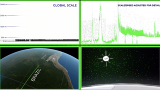
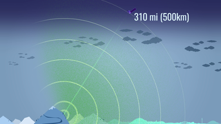
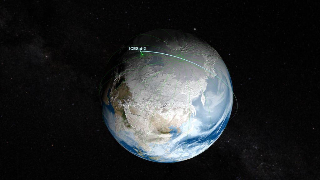
ICESat-2 is a spacecraft designed to accurately measure land and ice elevations on Earth. By comparing observations from different times, scientists will be able to study changes in elevations. ICESat-2 will be in a polar orbit which will provide high coverage near the poles where ice elevations are changing relatively quickly. This visualization shows ICESat-2's polar orbit from afar, then closer up. As we get close to the satellite, the 3 pairs of ICESat-2's ATLAS lidar laser beams begin to resolve. A ground track shows ICESat-2's global coverage which repeats about once every 90 days.
The ATLAS lidar on ICESat-2 uses 3 pairs of laser beams to measure the earth’s elevation and elevation change. As a global mission, ICESat-2 will collect data over the entire globe, however the ATLAS instrument is optimized to measure land ice and sea ice elevation in the polar regions.
For more information on ICESat-2 click here.
ICESat-2 Orbit
The ATLAS lidar on ICESat-2 uses 3 pairs of laser beams to measure the earth’s elevation and elevation change. As a global mission, ICESat-2 will collect data over the entire globe, however the ATLAS instrument is optimized to measure land ice and sea ice elevation in the polar regions.
For more information on ICESat-2 click here.
Used Elsewhere In


Related

Visualization Credits
Greg Shirah (NASA/GSFC): Lead Visualizer
Laurence Schuler (ADNET Systems, Inc.): Technical Support
Ian Jones (ADNET Systems, Inc.): Technical Support
Ryan Fitzgibbons (USRA): Producer
Thorsten Markus (NASA/GSFC): Scientist
Timothy Rebold (Emergent Space Technologies LLC): Data Provider
Laurence Schuler (ADNET Systems, Inc.): Technical Support
Ian Jones (ADNET Systems, Inc.): Technical Support
Ryan Fitzgibbons (USRA): Producer
Thorsten Markus (NASA/GSFC): Scientist
Timothy Rebold (Emergent Space Technologies LLC): Data Provider
Please give credit for this item to:
NASA's Scientific Visualization Studio
NASA's Scientific Visualization Studio
Short URL to share this page:
https://svs.gsfc.nasa.gov/4373
Data Used:
Note: While we identify the data sets used in these visualizations, we do not store any further details nor the data sets themselves on our site.
This item is part of this series:
ICESat
Keywords:
SVS >> HDTV
GCMD >> Earth Science >> Spectral/Engineering >> Platform Characteristics >> Orbital Characteristics
SVS >> Orbit
SVS >> Hyperwall
NASA Science >> Earth
SVS >> ICESat-2
GCMD keywords can be found on the Internet with the following citation: Olsen, L.M., G. Major, K. Shein, J. Scialdone, S. Ritz, T. Stevens, M. Morahan, A. Aleman, R. Vogel, S. Leicester, H. Weir, M. Meaux, S. Grebas, C.Solomon, M. Holland, T. Northcutt, R. A. Restrepo, R. Bilodeau, 2013. NASA/Global Change Master Directory (GCMD) Earth Science Keywords. Version 8.0.0.0.0
https://svs.gsfc.nasa.gov/4373
Data Used:
Terra and Aqua/MODIS/Blue Marble: Next Generation also referred to as: BMNG
Credit:
The Blue Marble data is courtesy of Reto Stockli (NASA/GSFC).
The Blue Marble data is courtesy of Reto Stockli (NASA/GSFC).
Hipparcos/Telescope/Tycho 2 Catalogue also referred to as: Tycho Catalogue
DatabaseGEOS Atmospheric Model
Model - NASA GMAOICESat-2/STK Ephemeris
EphemerisThis item is part of this series:
ICESat
Keywords:
SVS >> HDTV
GCMD >> Earth Science >> Spectral/Engineering >> Platform Characteristics >> Orbital Characteristics
SVS >> Orbit
SVS >> Hyperwall
NASA Science >> Earth
SVS >> ICESat-2
GCMD keywords can be found on the Internet with the following citation: Olsen, L.M., G. Major, K. Shein, J. Scialdone, S. Ritz, T. Stevens, M. Morahan, A. Aleman, R. Vogel, S. Leicester, H. Weir, M. Meaux, S. Grebas, C.Solomon, M. Holland, T. Northcutt, R. A. Restrepo, R. Bilodeau, 2013. NASA/Global Change Master Directory (GCMD) Earth Science Keywords. Version 8.0.0.0.0


