Earth
ID: 4328
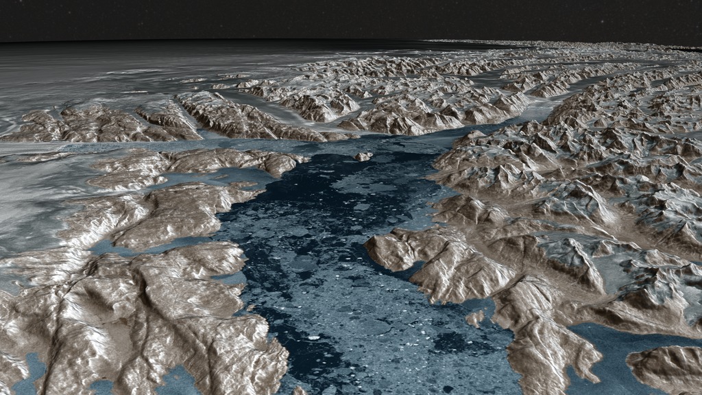
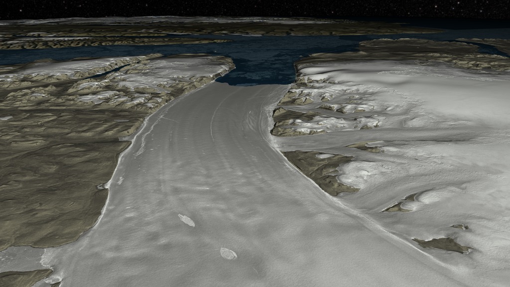
This animation is based on 30-meter topography data for Greenland along with an ocean and an ice sheet mask provided by the Greenland Ice Mapping Project (GIMP) at Ohio State. Each of these datasets consists of a 6 x 6 array of 124 megapixel tiles.
The surface texture is derived from seven sets of 20-meter Radarsat reflectance data from the Canadian Space Agency, mosaicked at the University of Washington's Applied Physics Lab and accurately registered to the topography data. Each of six tile sets represents data for one year between 2000 and 2013, while the final one is a composite of the six years that has most areas of missing data resolved. Each of these tile sets consist of a 5 x 5 array of 421 megapixel tiles.
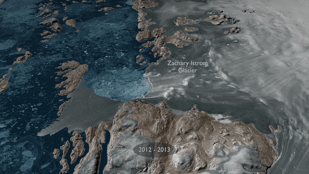
The false color of the surface is derived as follows. Three different color scales are applied to the floating point Radarsat reflectance data based on their relationship within the GIMP masks. Areas within the ice sheet mask are mapped to a color ramp from white (high) to grey (low). Areas within the land region of the ocean mask but not in the ice sheet mask are similarly mapped to a color ramp of light to dark tan. The area indicating ocean is mapped to blue.
Greenland's Glaciers as seen by RadarSat
The surface texture is derived from seven sets of 20-meter Radarsat reflectance data from the Canadian Space Agency, mosaicked at the University of Washington's Applied Physics Lab and accurately registered to the topography data. Each of six tile sets represents data for one year between 2000 and 2013, while the final one is a composite of the six years that has most areas of missing data resolved. Each of these tile sets consist of a 5 x 5 array of 421 megapixel tiles.
The false color of the surface is derived as follows. Three different color scales are applied to the floating point Radarsat reflectance data based on their relationship within the GIMP masks. Areas within the ice sheet mask are mapped to a color ramp from white (high) to grey (low). Areas within the land region of the ocean mask but not in the ice sheet mask are similarly mapped to a color ramp of light to dark tan. The area indicating ocean is mapped to blue.
Used Elsewhere In
Related
Visualization Credits
Cindy Starr (Global Science and Technology, Inc.): Lead Visualizer
Greg Shirah (NASA/GSFC): Visualizer
Ian Howat (Ohio State University): Scientist
Ian Joughin (Polar Science Center, University of Washington): Scientist
Twila Moon (National Snow & Ice Data Center, CIRES, University of Colorado, Boulder): Scientist
Jefferson Beck (USRA): Producer
Greg Shirah (NASA/GSFC): Visualizer
Ian Howat (Ohio State University): Scientist
Ian Joughin (Polar Science Center, University of Washington): Scientist
Twila Moon (National Snow & Ice Data Center, CIRES, University of Colorado, Boulder): Scientist
Jefferson Beck (USRA): Producer
Please give credit for this item to:
NASA's Scientific Visualization Studio
Radarsat data courtesy of the Canadian Space Agency, mosaicked by Ian Joughin, Applied Physics Laboratory, University of Washington
GIMP Topography and Ice/Land/Water mask courtesy of the BPRC Glacier Dynamics Research Group, Ohio State University
The Blue Marble data is courtesy of Reto Stockli (NASA/GSFC).
Short URL to share this page:
https://svs.gsfc.nasa.gov/4328
Data Used:
Note: While we identify the data sets used in these visualizations, we do not store any further details nor the data sets themselves on our site.
Keywords:
SVS >> HDTV
GCMD >> Earth Science >> Cryosphere >> Glaciers/Ice Sheets >> Ice Sheets
GCMD >> Earth Science >> Hydrosphere >> Glaciers/Ice Sheets >> Ice Sheets
GCMD >> Location >> Greenland
SVS >> Hyperwall
NASA Science >> Earth
GCMD >> Earth Science >> Terrestrial Hydrosphere >> Glaciers/Ice Sheets >> Ice Sheets
NASA Earth Science Focus Areas >> Climate Variability and Change
GCMD keywords can be found on the Internet with the following citation: Olsen, L.M., G. Major, K. Shein, J. Scialdone, S. Ritz, T. Stevens, M. Morahan, A. Aleman, R. Vogel, S. Leicester, H. Weir, M. Meaux, S. Grebas, C.Solomon, M. Holland, T. Northcutt, R. A. Restrepo, R. Bilodeau, 2013. NASA/Global Change Master Directory (GCMD) Earth Science Keywords. Version 8.0.0.0.0
https://svs.gsfc.nasa.gov/4328
Data Used:
RADARSAT-1/SAR
2000 - 2013
Credit:
Additional credit goes to Canadian Space Agency, RADARSAT International Inc.
Additional credit goes to Canadian Space Agency, RADARSAT International Inc.
Greenland Mapping Project (GIMP) Digital Elevation Model also referred to as: GIMP Greenland DEM
Data Compilation - Courtesy of Ian Howat, OSU - 2003 - 2009Keywords:
SVS >> HDTV
GCMD >> Earth Science >> Cryosphere >> Glaciers/Ice Sheets >> Ice Sheets
GCMD >> Earth Science >> Hydrosphere >> Glaciers/Ice Sheets >> Ice Sheets
GCMD >> Location >> Greenland
SVS >> Hyperwall
NASA Science >> Earth
GCMD >> Earth Science >> Terrestrial Hydrosphere >> Glaciers/Ice Sheets >> Ice Sheets
NASA Earth Science Focus Areas >> Climate Variability and Change
GCMD keywords can be found on the Internet with the following citation: Olsen, L.M., G. Major, K. Shein, J. Scialdone, S. Ritz, T. Stevens, M. Morahan, A. Aleman, R. Vogel, S. Leicester, H. Weir, M. Meaux, S. Grebas, C.Solomon, M. Holland, T. Northcutt, R. A. Restrepo, R. Bilodeau, 2013. NASA/Global Change Master Directory (GCMD) Earth Science Keywords. Version 8.0.0.0.0


