Earth
ID: 3813
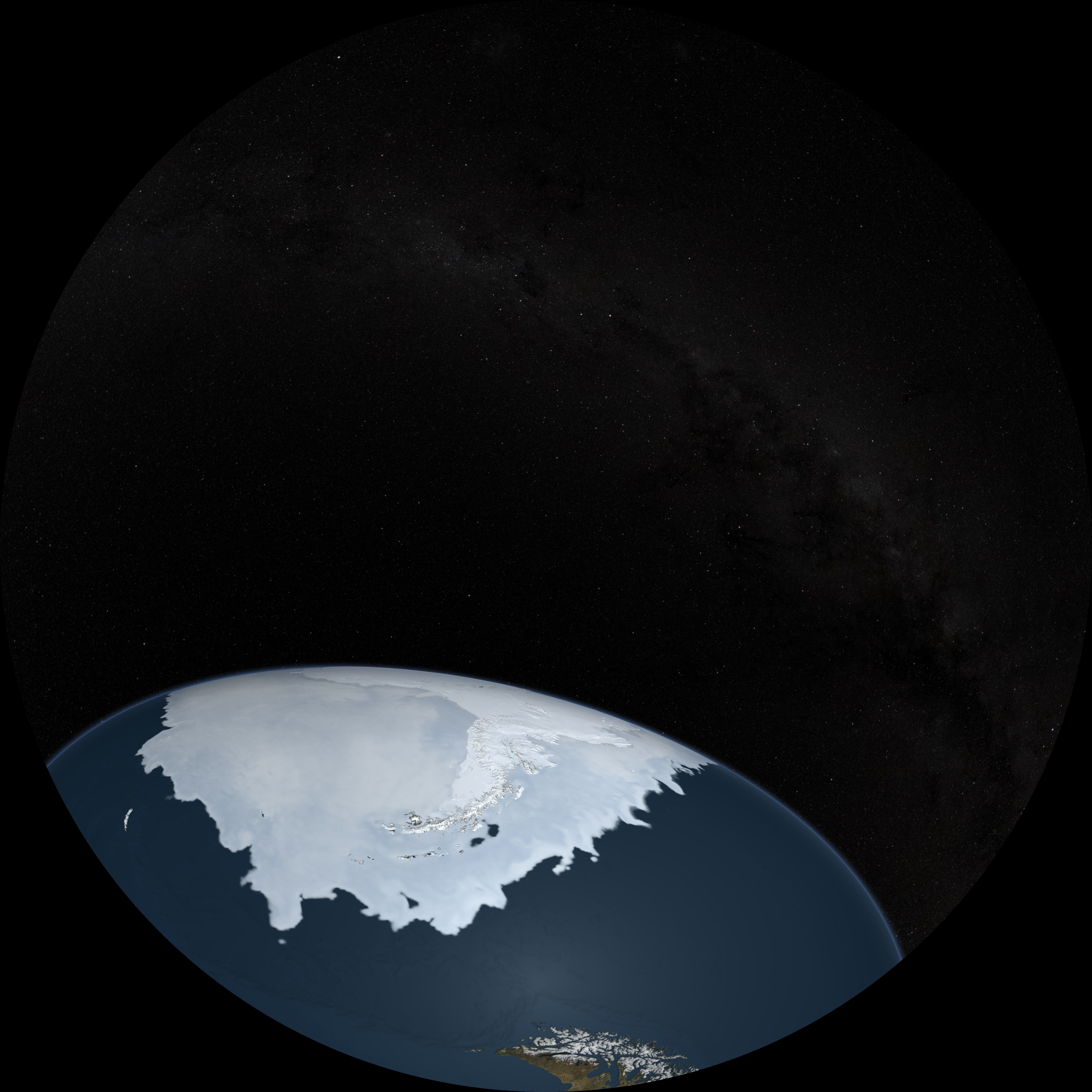
Sea ice is frozen seawater floating on the surface of the ocean. Some sea ice is semi-permanent, persisting from year to year, and some is seasonal, melting and refreezing from season to season. The sea ice cover reaches its minimum extent at the end of each summer and the remaining ice is called the perennial ice cover. This animation first shows the advance and retreat of the Arctic sea ice followed by same for the Antarctic sea ice. The sea ice changes from day to day showing a running 3-day average sea ice concentration in the region where the concentration is greater than 15%. The blueish white color of the sea ice is derived from a 3-day running miniimum of the AMSR-E 89 GHz brightness temperature. The animation ends by flying over the Antarctic Peninsula.
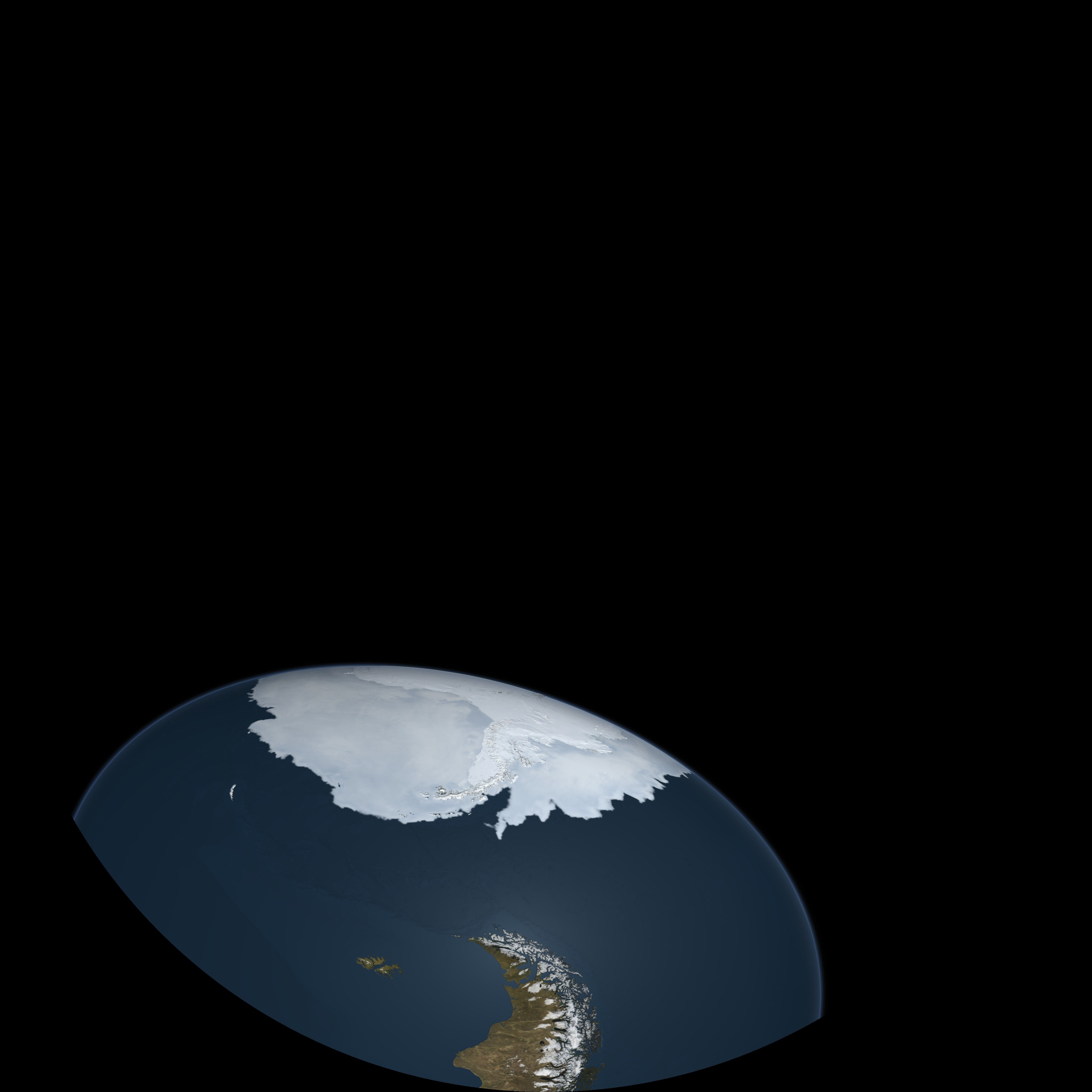
Arctic and Antarctic Sea Ice for the Dynamic Earth Dome Show
This was created for a planetarium dome show called Dynamic Earth and is produced in 'domemaster format'. The domemaster format was created by rendering 7 separate 2048x2048 camera tiles. The tiles were then stitched together to form final domemaster at 4096x4096 resolution. Both the tiles and the domemaster were rendered with 16 bits per channel with no gamma correction. Two domemaster layers were generated for this animation: the Earth showing sea ice advancing or retreating rendered with transparency and the star background without transparency.
This visualization was shown in the "VR Village" at SIGGRAPH 2015.
Visualization Credits
Cindy Starr (Global Science and Technology, Inc.): Lead Visualizer
Greg Shirah (NASA/GSFC): Animator
Lori Perkins (NASA/GSFC): Animator
Thomas Lucas (Thomas Lucas Productions): Producer
Josefino Comiso (NASA/GSFC): Scientist
James W. Williams (GST): Project Support
Shiloh Heurich (GST): Project Support
Greg Shirah (NASA/GSFC): Animator
Lori Perkins (NASA/GSFC): Animator
Thomas Lucas (Thomas Lucas Productions): Producer
Josefino Comiso (NASA/GSFC): Scientist
James W. Williams (GST): Project Support
Shiloh Heurich (GST): Project Support
Please give credit for this item to:
NASA/Goddard Space Flight Center Scientific Visualization Studio
NASA/Goddard Space Flight Center Scientific Visualization Studio
Short URL to share this page:
https://svs.gsfc.nasa.gov/3813
Missions:
Ice, Cloud, and land Elevation Satellite (ICESat)
Landsat
Data Used:
Note: While we identify the data sets used in these visualizations, we do not store any further details nor the data sets themselves on our site.
This item is part of these series:
Dome Show Planetarium
Dynamic Earth Dome Show
SIGGRAPH 2015
Keywords:
DLESE >> Cryology
DLESE >> Physical oceanography
GCMD >> Earth Science >> Cryosphere
GCMD >> Earth Science >> Cryosphere >> Sea Ice
GCMD >> Earth Science >> Oceans >> Sea Ice
GCMD >> Earth Science >> Cryosphere >> Sea Ice >> Ice Extent
GCMD >> Earth Science >> Cryosphere >> Sea Ice >> Ice Growth/Melt
GCMD >> Earth Science >> Cryosphere >> Sea Ice >> Sea Ice Concentration
GCMD >> Earth Science >> Cryosphere >> Sea Ice >> Sea Ice Motion
GCMD >> Earth Science >> Cryosphere >> Snow/Ice >> Freeze/Thaw
GCMD >> Earth Science >> Cryosphere >> Snow/Ice >> Ice Extent
GCMD >> Earth Science >> Cryosphere >> Snow/Ice >> Ice Growth/Melt
GCMD >> Earth Science >> Cryosphere >> Snow/Ice >> Ice Motion
GCMD >> Earth Science >> Hydrosphere >> Snow/Ice >> Ice Extent
GCMD >> Earth Science >> Hydrosphere >> Snow/Ice >> Ice Motion
GCMD >> Earth Science >> Oceans >> Sea Ice >> Ice Extent
GCMD >> Earth Science >> Oceans >> Sea Ice >> Ice Growth/Melt
SVS >> Sea ice Motion
NASA Science >> Earth
SVS >> Planetarium
GCMD keywords can be found on the Internet with the following citation: Olsen, L.M., G. Major, K. Shein, J. Scialdone, S. Ritz, T. Stevens, M. Morahan, A. Aleman, R. Vogel, S. Leicester, H. Weir, M. Meaux, S. Grebas, C.Solomon, M. Holland, T. Northcutt, R. A. Restrepo, R. Bilodeau, 2013. NASA/Global Change Master Directory (GCMD) Earth Science Keywords. Version 8.0.0.0.0
https://svs.gsfc.nasa.gov/3813
Missions:
Ice, Cloud, and land Elevation Satellite (ICESat)
Landsat
Data Used:
ICESat/GLAS also referred to as: GLAS/ICESat 1 km Laser Altimetry Digital Elevation Model of Greenland
Radarsat Antarctic Mapping Project (RAMP) Digital Elevation Model (DEM) also referred to as: RAMP DEM
Data Compilation - NSIDCLandsat-7/ETM+/Landsat Image Mosaic of Antarctica also referred to as: LIMA
Mosaic - NASA/GSFC, British Antarctic Survey, USGS EROS Data Center
Mosaicing to avoid clouds produced a high quality, nearly cloud-free benchmark data set of Antarctica for the International Polar Year from images collected primarily during 1999-2003.
Aqua/AMSR-E/Daily L3 12.5km Tb, Sea Ice Concentration, and Snow Depth also referred to as: Sea Ice Concentration
Aqua/AMSR-E/Daily L3 6.25 km 89 GHz Brightness Temperature (Tb)
This item is part of these series:
Dome Show Planetarium
Dynamic Earth Dome Show
SIGGRAPH 2015
Keywords:
DLESE >> Cryology
DLESE >> Physical oceanography
GCMD >> Earth Science >> Cryosphere
GCMD >> Earth Science >> Cryosphere >> Sea Ice
GCMD >> Earth Science >> Oceans >> Sea Ice
GCMD >> Earth Science >> Cryosphere >> Sea Ice >> Ice Extent
GCMD >> Earth Science >> Cryosphere >> Sea Ice >> Ice Growth/Melt
GCMD >> Earth Science >> Cryosphere >> Sea Ice >> Sea Ice Concentration
GCMD >> Earth Science >> Cryosphere >> Sea Ice >> Sea Ice Motion
GCMD >> Earth Science >> Cryosphere >> Snow/Ice >> Freeze/Thaw
GCMD >> Earth Science >> Cryosphere >> Snow/Ice >> Ice Extent
GCMD >> Earth Science >> Cryosphere >> Snow/Ice >> Ice Growth/Melt
GCMD >> Earth Science >> Cryosphere >> Snow/Ice >> Ice Motion
GCMD >> Earth Science >> Hydrosphere >> Snow/Ice >> Ice Extent
GCMD >> Earth Science >> Hydrosphere >> Snow/Ice >> Ice Motion
GCMD >> Earth Science >> Oceans >> Sea Ice >> Ice Extent
GCMD >> Earth Science >> Oceans >> Sea Ice >> Ice Growth/Melt
SVS >> Sea ice Motion
NASA Science >> Earth
SVS >> Planetarium
GCMD keywords can be found on the Internet with the following citation: Olsen, L.M., G. Major, K. Shein, J. Scialdone, S. Ritz, T. Stevens, M. Morahan, A. Aleman, R. Vogel, S. Leicester, H. Weir, M. Meaux, S. Grebas, C.Solomon, M. Holland, T. Northcutt, R. A. Restrepo, R. Bilodeau, 2013. NASA/Global Change Master Directory (GCMD) Earth Science Keywords. Version 8.0.0.0.0


