Earth
ID: 3744
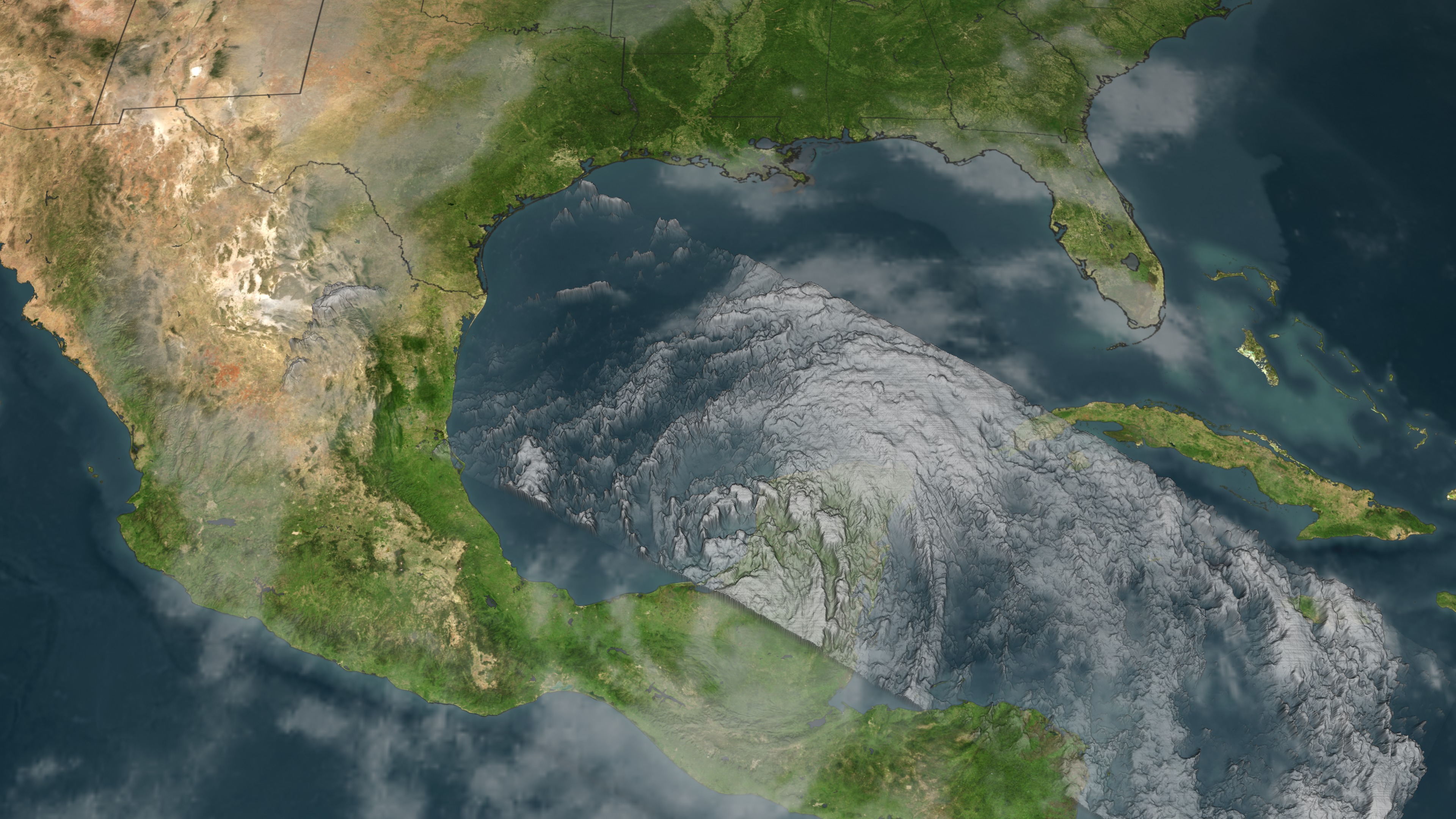
NASA's TRMM spacecraft observed this view of Tropical Depression Alex on June 27, 2010 at 2214 UTC (6:14 PM EST). Tropical depression Alex was near the western coast of Mexico's Yucatan Peninsula. Alex had weakened and wasn't dropping the very heavy rainfall that had occurred a day earlier causing deadly flooding. At the time of this image, Alex had winds estimated at 35 knots (~40.3 mph) and a pressure reading of 991 mb. The rain structure is taken by TRMM's Tropical Microwave Imager (TMI) and TRMM's Precitation Radar (PR) instruments. The clouds are taken by TRMM's visible-infrared radiometer (VIRS) and the National Oceanic and Atmospheric Administration (NOAA) Geostationary Operational Environmental Satellite (GOES-13) infrared instrument. TRMM looks underneath of the storm's clouds to reveal the underlying rain structure. The colored isosurface under the clouds show the rain seen by the PR instrument. Areas of extremely heavy rainfall are colored in red. Heavy rainfall are colored in yellow, moderate rainfall are colored in green, and light rain are in blue.
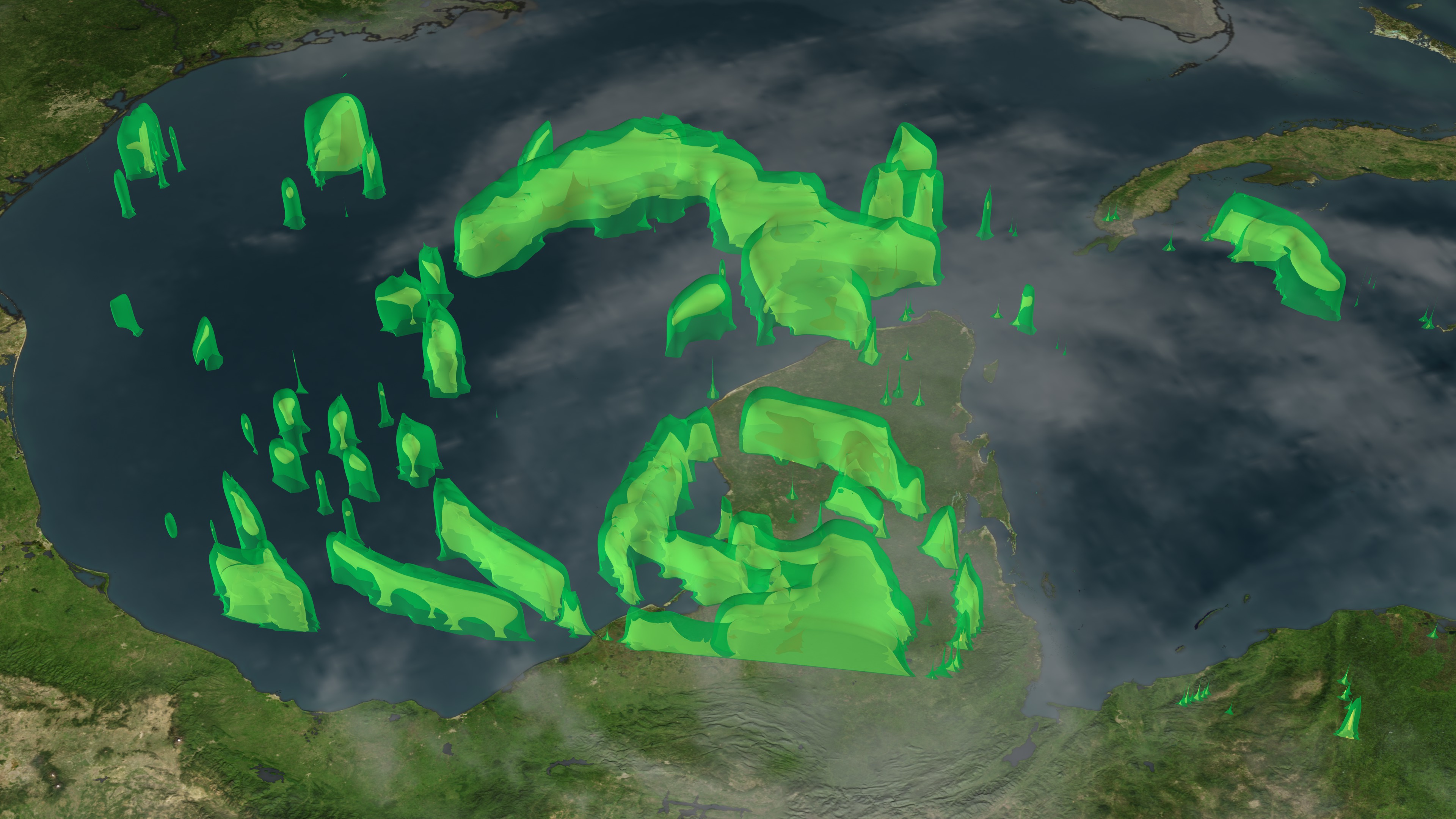
Tropical Depression ALEX hits Mexico's Yucatan Peninsula
Visualization Credits
Please give credit for this item to:
NASA/Goddard Space Flight Center Scientific Visualization Studio
NASA/Goddard Space Flight Center Scientific Visualization Studio
Short URL to share this page:
https://svs.gsfc.nasa.gov/3744
Mission:
Tropical Rainfall Measuring Mission - TRMM
Data Used:
Note: While we identify the data sets used in these visualizations, we do not store any further details nor the data sets themselves on our site.
This item is part of these series:
Hurricanes
TRMM 3D Hurricanes
Keywords:
SVS >> HDTV
DLESE >> Natural hazards
GCMD >> Earth Science >> Atmosphere >> Atmospheric Phenomena >> Hurricanes
SVS >> GOES
SVS >> Copenhagen
NASA Science >> Earth
GCMD keywords can be found on the Internet with the following citation: Olsen, L.M., G. Major, K. Shein, J. Scialdone, S. Ritz, T. Stevens, M. Morahan, A. Aleman, R. Vogel, S. Leicester, H. Weir, M. Meaux, S. Grebas, C.Solomon, M. Holland, T. Northcutt, R. A. Restrepo, R. Bilodeau, 2013. NASA/Global Change Master Directory (GCMD) Earth Science Keywords. Version 8.0.0.0.0
https://svs.gsfc.nasa.gov/3744
Mission:
Tropical Rainfall Measuring Mission - TRMM
Data Used:
TRMM/VIRS
06-27-2010 2214 UTCTRMM/TMI
06-27-2010 2214 UTCGOES
06-27-2010 2210 UTCTRMM/PR
06-27-2010 2214 UTCThis item is part of these series:
Hurricanes
TRMM 3D Hurricanes
Keywords:
SVS >> HDTV
DLESE >> Natural hazards
GCMD >> Earth Science >> Atmosphere >> Atmospheric Phenomena >> Hurricanes
SVS >> GOES
SVS >> Copenhagen
NASA Science >> Earth
GCMD keywords can be found on the Internet with the following citation: Olsen, L.M., G. Major, K. Shein, J. Scialdone, S. Ritz, T. Stevens, M. Morahan, A. Aleman, R. Vogel, S. Leicester, H. Weir, M. Meaux, S. Grebas, C.Solomon, M. Holland, T. Northcutt, R. A. Restrepo, R. Bilodeau, 2013. NASA/Global Change Master Directory (GCMD) Earth Science Keywords. Version 8.0.0.0.0


