Earth
ID: 3711
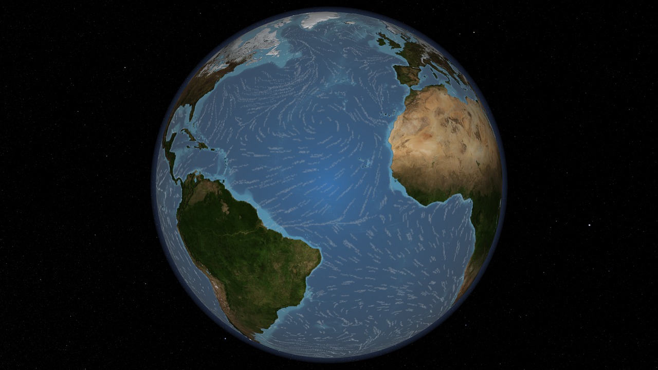
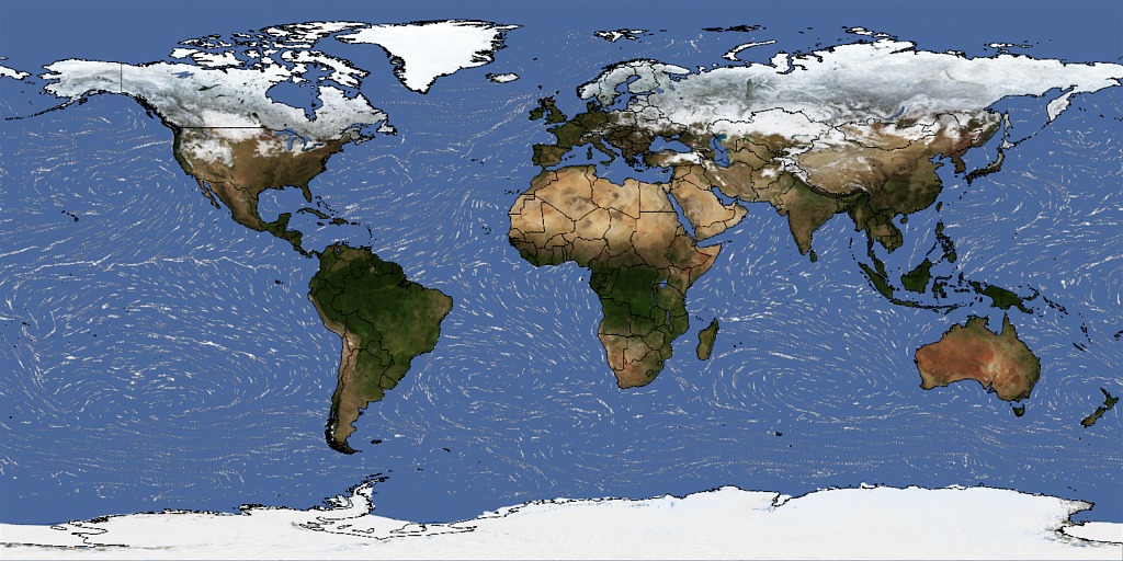
Satellite data can be used to observe the dramatic ebb and flow of the our planet's water system from space. This animation of QuikSCAT's sea surface winds is match framed to animation entries 3707, 3708, 3709, and 3710. The SeaWinds Scatterometer instrument on the QuikSCAT satellite captures the always moving and complex sea surface. The mission has also provided critical information for monitoring, modeling, forecasting and researching our atmosphere, ocean and climate.By any measure of success, the 10-year-old QuikSCAT mission is a unique national resource that has achieved and far surpassed its science objectives. Designed for a two-year lifetime, QuikSCAT has been used around the globe by the world's operational meteorological agencies to improve weather forecasts and identify the location, size and strength of hurricanes and other storms in the open ocean. More information on QuikSCAT is online at: http://winds.jpl.nasa.gov/missions/quikscat/index.cfm.
Five Spheres - Water
Visualization Credits
Lori Perkins (NASA/GSFC): Lead Animator
Horace Mitchell (NASA/GSFC): Animator
Ivy Flores (IRC/UMBC): Video Editor
Jennifer A. Shoemaker (UMBC): Producer
Horace Mitchell (NASA/GSFC): Animator
Ivy Flores (IRC/UMBC): Video Editor
Jennifer A. Shoemaker (UMBC): Producer
Please give credit for this item to:
NASA/Goddard Space Flight Center Scientific Visualization Studio
NASA/Goddard Space Flight Center Scientific Visualization Studio
Short URL to share this page:
https://svs.gsfc.nasa.gov/3711
Missions:
QuikSCAT
Terra
Data Used:
Note: While we identify the data sets used in these visualizations, we do not store any further details nor the data sets themselves on our site.
This item is part of this series:
Know Your Earth
Keywords:
SVS >> HDTV
SVS >> NDVI
DLESE >> Physical geography
GCMD >> Earth Science >> Atmosphere >> Atmospheric Water Vapor >> Water Vapor
GCMD >> Earth Science >> Land Surface >> Land Use/Land Cover >> Land Cover
SVS >> For Educators
SVS >> Atmosphere >> Winds >> Circulation
SVS >> Water Cycle >> Condensation
SVS >> Land/Sea Breeze
SVS >> Atmosphere >> Circulation
NASA Science >> Earth
GCMD keywords can be found on the Internet with the following citation: Olsen, L.M., G. Major, K. Shein, J. Scialdone, S. Ritz, T. Stevens, M. Morahan, A. Aleman, R. Vogel, S. Leicester, H. Weir, M. Meaux, S. Grebas, C.Solomon, M. Holland, T. Northcutt, R. A. Restrepo, R. Bilodeau, 2013. NASA/Global Change Master Directory (GCMD) Earth Science Keywords. Version 8.0.0.0.0
https://svs.gsfc.nasa.gov/3711
Missions:
QuikSCAT
Terra
Data Used:
QuikSCAT/SeaWinds/Wind
1/1/2006 - 2/7/2006Hipparcos/Telescope/Tycho 2 Catalogue also referred to as: Tycho Catalogue
DatabaseThis item is part of this series:
Know Your Earth
Keywords:
SVS >> HDTV
SVS >> NDVI
DLESE >> Physical geography
GCMD >> Earth Science >> Atmosphere >> Atmospheric Water Vapor >> Water Vapor
GCMD >> Earth Science >> Land Surface >> Land Use/Land Cover >> Land Cover
SVS >> For Educators
SVS >> Atmosphere >> Winds >> Circulation
SVS >> Water Cycle >> Condensation
SVS >> Land/Sea Breeze
SVS >> Atmosphere >> Circulation
NASA Science >> Earth
GCMD keywords can be found on the Internet with the following citation: Olsen, L.M., G. Major, K. Shein, J. Scialdone, S. Ritz, T. Stevens, M. Morahan, A. Aleman, R. Vogel, S. Leicester, H. Weir, M. Meaux, S. Grebas, C.Solomon, M. Holland, T. Northcutt, R. A. Restrepo, R. Bilodeau, 2013. NASA/Global Change Master Directory (GCMD) Earth Science Keywords. Version 8.0.0.0.0


