Earth
ID: 3588
This large resolution graphic was created to display a 10 foot by 7 foot exhibition for the Landsat Image Mosaic of Antarctica (LIMA) project at the Antarctic Treaty Consultative Meeting (ATCM) in Baltimore, Maryland on April 16-17, 2009. This meeting marks the 50th Anniversary of the Antarctic Treaty. After this meeting, the printed image will be displayed in building 33 of Goddard Space Flight Center in Greenbelt, Maryland.
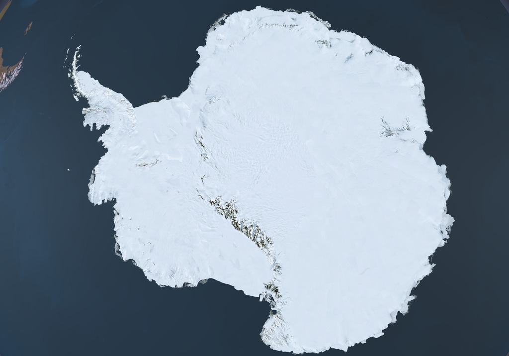

Landsat Image Mosaic of Antarctica Graphic
The Landsat Image Mosaic of Antarctica (LIMA) is a data product funded by the National Science Foundation (NSF) and jointly produced by the U.S. Geological Survey (USGS), the British Antarctic Survey (BAS), and the National Aeronautics and Space Administration (NASA). The LIMA data shown here uses the pan-chromatic band and has a resolution of 15 meters per pixel. The LandSat satellite does not fly over the South Pole so the hole has been filled with data from NASA's MODIS Mosaic of Antarctica (MOA).
Visualization Credits
Lori Perkins (NASA/GSFC): Lead Animator
Cindy Starr (Global Science and Technology, Inc.): Visualizer
Bob Bindschadler (NASA/GSFC): Scientist
Cindy Starr (Global Science and Technology, Inc.): Visualizer
Bob Bindschadler (NASA/GSFC): Scientist
Please give credit for this item to:
NASA/Goddard Space Flight Center Scientific Visualization Studio. LIMA Data provided by: Patricia Vornberger (SAIC) LIMA data produced by U.S. Geological Survey (USGS), the British Antarctic Survey (BAS) and NASA
NASA/Goddard Space Flight Center Scientific Visualization Studio. LIMA Data provided by: Patricia Vornberger (SAIC) LIMA data produced by U.S. Geological Survey (USGS), the British Antarctic Survey (BAS) and NASA
Short URL to share this page:
https://svs.gsfc.nasa.gov/3588
Missions:
Landsat
Terra
Data Used:
Note: While we identify the data sets used in these visualizations, we do not store any further details nor the data sets themselves on our site.
This item is part of this series:
Landsat Image Mosaic of Antarctica
Keywords:
SVS >> HDTV
GCMD >> Earth Science >> Cryosphere >> Glaciers/Ice Sheets
GCMD >> Earth Science >> Cryosphere >> Glaciers/Ice Sheets >> Glacier Elevation/Ice Sheet Elevation
GCMD >> Earth Science >> Cryosphere >> Glaciers/Ice Sheets >> Glacier Topography/Ice Sheet Topography
GCMD >> Location >> Antarctica
NASA Science >> Earth
GCMD keywords can be found on the Internet with the following citation: Olsen, L.M., G. Major, K. Shein, J. Scialdone, S. Ritz, T. Stevens, M. Morahan, A. Aleman, R. Vogel, S. Leicester, H. Weir, M. Meaux, S. Grebas, C.Solomon, M. Holland, T. Northcutt, R. A. Restrepo, R. Bilodeau, 2013. NASA/Global Change Master Directory (GCMD) Earth Science Keywords. Version 8.0.0.0.0
https://svs.gsfc.nasa.gov/3588
Missions:
Landsat
Terra
Data Used:
Landsat-7/ETM+/Band Combination 3, 2, 1
Landsat-7/ETM+/Landsat Image Mosaic of Antarctica also referred to as: LIMA
Mosaic - NASA/GSFC, British Antarctic Survey, USGS EROS Data Center - 12/25/1999 - 12/31/2001
Mosaicing to avoid clouds produced a high quality, nearly cloud-free benchmark data set of Antarctica for the International Polar Year from images collected primarily during 1999-2003.
Terra and Aqua/MODIS/MODIS Mosaic of Antarctica (MOA) Image Map also referred to as: MOA
Mosaic - National Snow and Ice Data Center (NSIDC) and the University of New Hampshire - 11/20/2003 - 02/29/2004
Staff from the National Snow and Ice Data Center (NSIDC) and the University of New Hampshire have assembled two digital image maps of surface morphology and optical snow grain size that cover the Antarctic continent and its surrounding islands. The MODIS Mosaic of Antarctica (MOA) image maps are derived from composites of 260 MODIS (Moderate-resolution Imaging Spectroradiometer) orbit swaths acquired between 20 November 2003 and 29 February 2004. The MOA provides a cloud-free view of the ice sheet, ice shelves, and land surfaces, and a quantitative measure of optical snow grain size for snow- or ice-covered areas. All land areas larger than a few hundred meters that are south of 60° S are included in the mosaic, as well as persistent fast ice regions and some grounded icebergs present near the coast in the 2003-2004 austral summer. The MOA surface morphology image map is derived from digitally processed MODIS Band 1 data. The optical snow grain size image is compiled using a normalized ratio of atmospherically corrected, calibrated band radiance data from Bands 1 and 2.
This item is part of this series:
Landsat Image Mosaic of Antarctica
Keywords:
SVS >> HDTV
GCMD >> Earth Science >> Cryosphere >> Glaciers/Ice Sheets
GCMD >> Earth Science >> Cryosphere >> Glaciers/Ice Sheets >> Glacier Elevation/Ice Sheet Elevation
GCMD >> Earth Science >> Cryosphere >> Glaciers/Ice Sheets >> Glacier Topography/Ice Sheet Topography
GCMD >> Location >> Antarctica
NASA Science >> Earth
GCMD keywords can be found on the Internet with the following citation: Olsen, L.M., G. Major, K. Shein, J. Scialdone, S. Ritz, T. Stevens, M. Morahan, A. Aleman, R. Vogel, S. Leicester, H. Weir, M. Meaux, S. Grebas, C.Solomon, M. Holland, T. Northcutt, R. A. Restrepo, R. Bilodeau, 2013. NASA/Global Change Master Directory (GCMD) Earth Science Keywords. Version 8.0.0.0.0


