Sun
Planets and Moons
ID: 3576
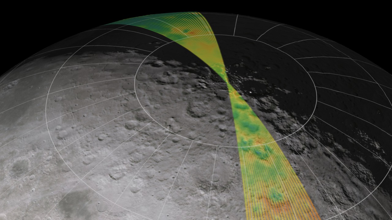
A satellite's ground track shows the path of its orbit on the surface of the parent body. Lunar Reconnaissance Orbiter will be placed in a nearly circular polar orbit about 50 kilometers (31 miles) above the surface of the Moon, completing each orbit in a little less than two hours. The orientation of this orbit remains fixed in space, relative to the stars, while the Moon slowly rotates beneath it as they travel together around the Earth, allowing LRO to scan the entire surface of the Moon every two weeks.
LRO Ground Track
As this animation shows, the density of the ground coverage provided by a polar orbit is greatest at the poles. For the Moon, this is also where a great deal of current interest lies, since permanently shadowed areas at the poles may harbor water ice. This is also where some high-altitude areas are in gentle but perennial sunlight, providing the lighting and power supply for extended human exploration.
The animation depicts LRO's ground track over a period of seven days (89 orbits). The elevation map comprises low-resolution data from a number of sources, including the Clementine and JAXA/SELENE spacecraft, combined with high-resolution insets for the regions near the poles. The surface color is derived from photographs taken by Clementine.
Visualization Credits
Ernie Wright (UMBC): Lead Animator
Marte Newcombe (GST): Animator
Andrew Freeberg (NASA/GSFC): Producer
Richard Vondrak (NASA/GSFC): Scientist
Marte Newcombe (GST): Animator
Andrew Freeberg (NASA/GSFC): Producer
Richard Vondrak (NASA/GSFC): Scientist
Please give credit for this item to:
NASA/Goddard Space Flight Center Scientific Visualization Studio. Some elevation data provided by JAXA/KAGUYA(SELENE).
NASA/Goddard Space Flight Center Scientific Visualization Studio. Some elevation data provided by JAXA/KAGUYA(SELENE).
Short URL to share this page:
https://svs.gsfc.nasa.gov/3576
Data Used:
Note: While we identify the data sets used in these visualizations, we do not store any further details nor the data sets themselves on our site.
This item is part of these series:
The Moon
LRO Pre-launch
Keywords:
SVS >> Elevation data
SVS >> False Color
SVS >> HDTV
SVS >> Moon
SVS >> North Pole
SVS >> South Pole
SVS >> Orbit
SVS >> Lunar Reconnaissance Orbiter
SVS >> For Educators
SVS >> Lunar Topography
SVS >> Satellite Ground Track
SVS >> Lunar Elevation Map
SVS >> Satellites >> Lunar
NASA Science >> Sun
NASA Science >> Planets and Moons
https://svs.gsfc.nasa.gov/3576
Data Used:
KAGUYA/Laser Altimeter (LALT)/DEM
JAXA - 2007-12-30 to 2008-03-31
Formerly known as "SELENE".
Tycho DEM
1998Unified Lunar Control Network 2005 also referred to as: ULCN 2005
Data Compilation - USGS - 1970 to 2005
The ULCN 2005 (Unified Lunar Control Network 2005) is a lunar control point network that precisely measured 272,931 pieces of data produced by the USGS using existing lunar imagery or data from the Clementine and other observations.
This item is part of these series:
The Moon
LRO Pre-launch
Keywords:
SVS >> Elevation data
SVS >> False Color
SVS >> HDTV
SVS >> Moon
SVS >> North Pole
SVS >> South Pole
SVS >> Orbit
SVS >> Lunar Reconnaissance Orbiter
SVS >> For Educators
SVS >> Lunar Topography
SVS >> Satellite Ground Track
SVS >> Lunar Elevation Map
SVS >> Satellites >> Lunar
NASA Science >> Sun
NASA Science >> Planets and Moons


