Earth
ID: 3419
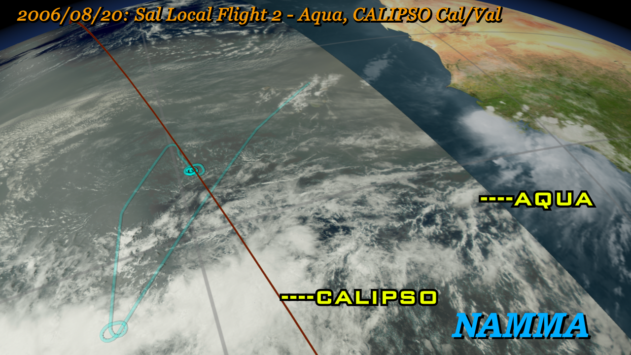
The NASA African Monsoon Multidisciplinary Analysis (NAMMA) campaign was a field research campaign to study African Easterly waves off the western coast of Africa. A DC-8 aircraft was flown out of the island of Sal, Cape Verde, in August and September 2006, and was outfitted with atmospheric sensors that measured data in this region that could be compared with satellite, balloon, and ground-based sensors to build up a comprehensive picture of the atmosphere in this region. This region is important in that it is one of the primary regions of tropical cyclogenesis, where Atlantic hurricanes form. This animation shows all the flight paths of the DC-8 during this campaign along with the corresponding cloud and satellite data from satellites.
NAMMA Aircraft Flights from Cape Verde
Visualization Credits
Horace Mitchell (NASA/GSFC): Lead Animator
Greg Shirah (NASA/GSFC): Animator
Anthony Guillory (NASA/GSFC Wallops): Scientist
Greg Shirah (NASA/GSFC): Animator
Anthony Guillory (NASA/GSFC Wallops): Scientist
Please give credit for this item to:
NASA/Goddard Space Flight Center Scientific Visualization Studio Additional Credits: NCEP Cloud Composite courtesy of NOAA's Climate Prediction Center.
NASA/Goddard Space Flight Center Scientific Visualization Studio Additional Credits: NCEP Cloud Composite courtesy of NOAA's Climate Prediction Center.
Short URL to share this page:
https://svs.gsfc.nasa.gov/3419
Missions:
CALIPSO
Cloudsat
Terra
Tropical Rainfall Measuring Mission - TRMM
Data Used:
Note: While we identify the data sets used in these visualizations, we do not store any further details nor the data sets themselves on our site.
Keywords:
SVS >> HDTV
GCMD >> Earth Science >> Spectral/Engineering >> Platform Characteristics >> Airspeed/Ground Speed
GCMD >> Earth Science >> Spectral/Engineering >> Platform Characteristics >> Orbital Characteristics
SVS >> GOES
NASA Science >> Earth
GCMD keywords can be found on the Internet with the following citation: Olsen, L.M., G. Major, K. Shein, J. Scialdone, S. Ritz, T. Stevens, M. Morahan, A. Aleman, R. Vogel, S. Leicester, H. Weir, M. Meaux, S. Grebas, C.Solomon, M. Holland, T. Northcutt, R. A. Restrepo, R. Bilodeau, 2013. NASA/Global Change Master Directory (GCMD) Earth Science Keywords. Version 8.0.0.0.0
https://svs.gsfc.nasa.gov/3419
Missions:
CALIPSO
Cloudsat
Terra
Tropical Rainfall Measuring Mission - TRMM
Data Used:
Aqua/MODIS
2006/08/15 - 2006/09/14Terra/MODIS
2006/08/15 - 2006/09/14CALIPSO/CALIOP
2006/08/15 - 2006/09/14
Cloud-Aerosol Lidar with Orthogonal Polarization
GOES-12/Imager/Visible
2006/08/15 - 2006/09/14TRMM/PR and TMI/Monthly Average Precipitation
2006/08/15 - 2006/09/14CloudSat/CPR/Cloud Cover
2006/08/15 - 2006/09/14Keywords:
SVS >> HDTV
GCMD >> Earth Science >> Spectral/Engineering >> Platform Characteristics >> Airspeed/Ground Speed
GCMD >> Earth Science >> Spectral/Engineering >> Platform Characteristics >> Orbital Characteristics
SVS >> GOES
NASA Science >> Earth
GCMD keywords can be found on the Internet with the following citation: Olsen, L.M., G. Major, K. Shein, J. Scialdone, S. Ritz, T. Stevens, M. Morahan, A. Aleman, R. Vogel, S. Leicester, H. Weir, M. Meaux, S. Grebas, C.Solomon, M. Holland, T. Northcutt, R. A. Restrepo, R. Bilodeau, 2013. NASA/Global Change Master Directory (GCMD) Earth Science Keywords. Version 8.0.0.0.0


