Earth
ID: 3355
A newer version of this animation is available here.
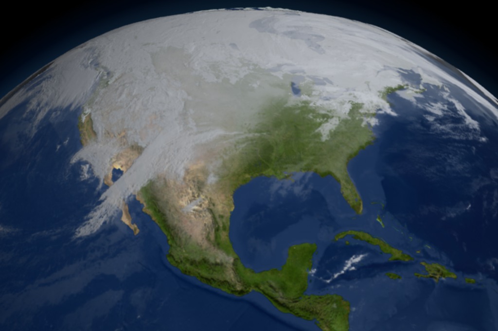
A Short Tour of the Cryosphere
This narrated, 5-minute animation shows a wealth of data collected from satellite observations of the cryosphere and the impact that recent cryospheric changes are making on our planet. This is a shorter version of a narrated, 7 1/2 minute animation entitled 'A Tour of the Cryosphere'.
See the above link for a detailed description of the full animation.
Two sections have been removed from the original animation: one showing a flyby of the South Pole station and glaciers feeding the Ross Ice Shelf and one showing solar data related to the Earth's energy balance.
For more information on the data sets used in this visualization, visit NASA's EOS DAAC website.
Visualization Credits
Alex Kekesi (Global Science and Technology, Inc.): Lead Animator
Cindy Starr (Global Science and Technology, Inc.): Visualizer
Ryan Boller (NASA/GSFC): Animator
Tom Bridgman (Global Science and Technology, Inc.): Animator
Randall Jones (GST): Animator
Kevin Mahoney (CSC): Animator
Horace Mitchell (NASA/GSFC): Animator
Marte Newcombe (GST): Animator
Lori Perkins (NASA/GSFC): Animator
Greg Shirah (NASA/GSFC): Animator
Stuart A. Snodgrass (GST): Animator
Eric Sokolowsky (GST): Animator
Michael Starobin (HTSI): Narrator
Walt Meier (NSIDC): Scientist
Waleed Abdalati (NASA/HQ): Scientist
Ronald Weaver (University of Colorado): Scientist
Mary Jo Brodzik (University of Colorado): Scientist
Richard Armstrong (University of Colorado): Scientist
Michael Starobin (HTSI): Writer
Jarrett Cohen (GST): Writer
Please give credit for this visualization to:
NASA/Goddard Space Flight Center Scientific Visualization Studio Designed by EOSDIS Outreach Team ESDIS Science Operations Office NASA Goddard Space Flight Center Carol Boquist, NASA Goddard Space Flight Center Jennifer Farnham-Brennan, Global Science and Technology, Inc. Dr. Brian Krupp, Global Science and Technology, Inc. Directed and Edited by Dr. Horace Mitchell, NASA Goddard Space Flight Center Written by Jarrett Cohen, Global Science and Technology, Inc. Michael Starobin, Honeywell Technology Solutions, Inc. Narrated by Michael Starobin, Honeywell Technology Solutions, Inc. Audio Engineering by Mike Velle, Honeywell Technology Solutions, Inc. Music by Michael Starobin, Honeywell Technology Solutions, Inc. MODIS Snow and Ice data courtesy of Dr. Dorothy Hall, NASA Goddard Space Flight Center Dr. Vince Salomonson, NASA Goddard Space Flight Center Dr. George Riggs, Science Systems and Applications, Inc. Arctic Sea Ice data courtesy of the National Snow and Ice Data Center Cooperative Institute for Research in the Environmental Sciences University of Colorado MODIS Imagery courtesy of the MODIS Land Rapid Response Project NASA Goddard Space Flight Center and the University of Maryland Jacques Descloitres, Science Systems and Applications, Inc. Jeffrey E. Schmaltz, Science Systems and Applications, Inc. Blue Marble MODIS data composite courtesy of the MODIS Science Team NASA Goddard Space Flight Center and the NASA Earth Observatory Reto Stockli, Science Systems and Applications, Inc. RADARSAT data courtesy of the Canadian Space Agency Jakobshavn Ice Velocity data courtesy of Dr. Ian Joughin, University of Washington QuikSCAT Seawinds data courtesy of the BYU Center for Remote Sensing Dr. David Long, Brigham Young University Permafrost data courtesy of the United States Geological Survey and the International Permafrost Association Topography data courtesy of the United States Geological Survey Cloud data courtesy of the National Oceanic and Atmospheric Administration Population data courtesy of the Socioeconomic Data and Applications Center SeaWiFS data courtesy of the SeaWiFS Project and GeoEye NOTE: All SeaWiFS images and data presented on this web site are for research and educational use only. All commercial use of SeaWiFS data must be coordinated with GeoEye (NOTE: In January 2013, DigitalGlobe and GeoEye combined to become one DigitalGlobe.). All other data courtesy of NASA NASA EOSDIS and other EOS data distributed by NASA's Distributed Active Archive Centers (DAACs) http://nasadaacs.eos.nasa.gov
NASA/Goddard Space Flight Center Scientific Visualization Studio Designed by EOSDIS Outreach Team ESDIS Science Operations Office NASA Goddard Space Flight Center Carol Boquist, NASA Goddard Space Flight Center Jennifer Farnham-Brennan, Global Science and Technology, Inc. Dr. Brian Krupp, Global Science and Technology, Inc. Directed and Edited by Dr. Horace Mitchell, NASA Goddard Space Flight Center Written by Jarrett Cohen, Global Science and Technology, Inc. Michael Starobin, Honeywell Technology Solutions, Inc. Narrated by Michael Starobin, Honeywell Technology Solutions, Inc. Audio Engineering by Mike Velle, Honeywell Technology Solutions, Inc. Music by Michael Starobin, Honeywell Technology Solutions, Inc. MODIS Snow and Ice data courtesy of Dr. Dorothy Hall, NASA Goddard Space Flight Center Dr. Vince Salomonson, NASA Goddard Space Flight Center Dr. George Riggs, Science Systems and Applications, Inc. Arctic Sea Ice data courtesy of the National Snow and Ice Data Center Cooperative Institute for Research in the Environmental Sciences University of Colorado MODIS Imagery courtesy of the MODIS Land Rapid Response Project NASA Goddard Space Flight Center and the University of Maryland Jacques Descloitres, Science Systems and Applications, Inc. Jeffrey E. Schmaltz, Science Systems and Applications, Inc. Blue Marble MODIS data composite courtesy of the MODIS Science Team NASA Goddard Space Flight Center and the NASA Earth Observatory Reto Stockli, Science Systems and Applications, Inc. RADARSAT data courtesy of the Canadian Space Agency Jakobshavn Ice Velocity data courtesy of Dr. Ian Joughin, University of Washington QuikSCAT Seawinds data courtesy of the BYU Center for Remote Sensing Dr. David Long, Brigham Young University Permafrost data courtesy of the United States Geological Survey and the International Permafrost Association Topography data courtesy of the United States Geological Survey Cloud data courtesy of the National Oceanic and Atmospheric Administration Population data courtesy of the Socioeconomic Data and Applications Center SeaWiFS data courtesy of the SeaWiFS Project and GeoEye NOTE: All SeaWiFS images and data presented on this web site are for research and educational use only. All commercial use of SeaWiFS data must be coordinated with GeoEye (NOTE: In January 2013, DigitalGlobe and GeoEye combined to become one DigitalGlobe.). All other data courtesy of NASA NASA EOSDIS and other EOS data distributed by NASA's Distributed Active Archive Centers (DAACs) http://nasadaacs.eos.nasa.gov
Short URL to share this page:
https://svs.gsfc.nasa.gov/3355
Missions:
Galileo
Ice, Cloud, and land Elevation Satellite (ICESat)
Landsat
QuikSCAT
Solar Radiation and Climate Experiment (SORCE)
Terra
Tropical Rainfall Measuring Mission - TRMM
Data Used:
Note: While we identify the data sets used in these visualizations, we do not store any further details nor the data sets themselves on our site.
Dates of Data Used:
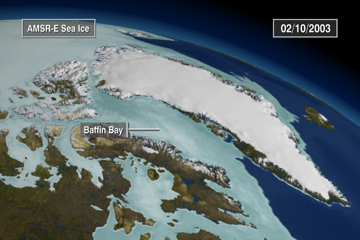
ASTER (05/30/2004) AMSR-E Level 3 12.5 km Sea Ice Concentration (10/01/2002 - 06/23/2003) AMSR-E Level 3 6.25 km Sea Ice Brightness Temperature (10/01/2002 - 06/23/2003) MODIS Blue Marble Landcover Infrared Global Geostationary Composite (a.k.a. GOES Cloud) (10/01/2002 - 03/31/2003) and (06/19/2003 - 06/22/2003) Circum-Arctic Map of Permafrost and Ground-Ice Conditions (1997) DMSP Operational Linescan System (OLS) (Earth-at-Night) ERS SAR-derived Glacial Flows (2001) GPW Population (SEDAC 1990 - 1995) ICESat/GLAS Cloud Height Profile (09/30/2003 - 10/01/2003) Landsat Imagery (07/07/2001, 05/20/2001, 05/23/2002, 05/19/2003) MODIS NDVI (06/06/2002 - 09/14/2002) and (06/06/2003 - 09/14/2003) MODIS imagery of Greenland (06/25/2003) MODIS imagery of B-15A (11/09/2004, 11/15/2004, 11/19/2004, 11/21/2004, 11/26/2004, 12/02/2004, 12/04/2004, 12/07/2004, 12/10/2004, 12/13/2004, 12/20/2004, 12/23/2004, 01/02/2005, 01/11/2005, 01/12/2005, 01/14/2005, 01/17/2005, 01/18/2005, 01/21/2005, 01/26/2005) MODIS imagery of Larsen (01/31/2002, 02/17/2002, 02/23/2002, 03/05/2002, 03/07/2002) MODIS Daily Sea Ice Surface Temperature (07/04/2002 - 07/23/2003) MODIS Daily Snow Cover (01/01/2002 - 06/30/2003) NSIDC World Glacier Inventory (1999) QuikSCAT Seawinds (03/09/2004 - 12/10/2004) Radarsat SAR Imagery (09/26/1997 - 11/04/1997) September Minimum Average Sea Ice Extent-15% mean contour derived from (1979 - 2002) SeaWiFS NDVI (06/01/2002 - 12/31/2003) NSIDC SSMI-derived Monthly Average Sea Ice Concentration derived from (1979 - 2002) NSIDC SSMI-derived September Minimum Sea Ice Concentration years (1979 - 2004) Topography (SRTM, USGS/GTOPO-30, Antarctic Digital Elevation Model (1999))
This item is part of this series:
Narrated Movies
Keywords:
DLESE >> Cryology
SVS >> Snow and Ice
GCMD >> Earth Science >> Cryosphere >> Frozen Ground >> Permafrost
GCMD >> Earth Science >> Cryosphere >> Glaciers/Ice Sheets >> Glacier Motion/Ice Sheet Motion
GCMD >> Earth Science >> Cryosphere >> Glaciers/Ice Sheets >> Glacier Topography/Ice Sheet Topography
GCMD >> Earth Science >> Cryosphere >> Glaciers/Ice Sheets >> Glaciers
GCMD >> Earth Science >> Cryosphere >> Glaciers/Ice Sheets >> Ice Sheets
GCMD >> Earth Science >> Cryosphere >> Sea Ice >> Ice Growth/Melt
GCMD >> Earth Science >> Cryosphere >> Sea Ice >> Ice Temperature
GCMD >> Earth Science >> Cryosphere >> Sea Ice >> Sea Ice Concentration
GCMD >> Earth Science >> Cryosphere >> Sea Ice >> Sea Ice Motion
GCMD >> Earth Science >> Cryosphere >> Snow/Ice >> Ice Growth/Melt
GCMD >> Earth Science >> Cryosphere >> Snow/Ice >> Ice Motion
GCMD >> Earth Science >> Cryosphere >> Snow/Ice >> Ice Velocity
GCMD >> Earth Science >> Cryosphere >> Snow/Ice >> Permafrost
GCMD >> Earth Science >> Cryosphere >> Snow/Ice >> Snow Cover
GCMD >> Earth Science >> Cryosphere >> Snow/Ice >> Snow/Ice Temperature
GCMD >> Earth Science >> Hydrosphere >> Glaciers/Ice Sheets >> Glacier Motion/Ice Sheet Motion
GCMD >> Earth Science >> Hydrosphere >> Glaciers/Ice Sheets >> Glacier Topography/Ice Sheet Topography
GCMD >> Earth Science >> Hydrosphere >> Glaciers/Ice Sheets >> Glaciers
GCMD >> Earth Science >> Hydrosphere >> Glaciers/Ice Sheets >> Ice Sheets
GCMD >> Earth Science >> Hydrosphere >> Snow/Ice >> Ice Growth/Melt
GCMD >> Earth Science >> Hydrosphere >> Snow/Ice >> Ice Motion
GCMD >> Earth Science >> Hydrosphere >> Snow/Ice >> Ice Velocity
GCMD >> Earth Science >> Hydrosphere >> Snow/Ice >> Permafrost
GCMD >> Earth Science >> Hydrosphere >> Snow/Ice >> Snow Cover
GCMD >> Earth Science >> Hydrosphere >> Snow/Ice >> Snow/Ice Temperature
SVS >> Sea Ice Surface Temperature
SVS >> GOES
DLESE >> Narrated
SVS >> Voice Over Talent
SVS >> CERES
NASA Science >> Earth
GCMD keywords can be found on the Internet with the following citation: Olsen, L.M., G. Major, K. Shein, J. Scialdone, S. Ritz, T. Stevens, M. Morahan, A. Aleman, R. Vogel, S. Leicester, H. Weir, M. Meaux, S. Grebas, C.Solomon, M. Holland, T. Northcutt, R. A. Restrepo, R. Bilodeau, 2013. NASA/Global Change Master Directory (GCMD) Earth Science Keywords. Version 8.0.0.0.0
Places you might have seen this:
'Research Shines Some Light On Mysteries of Antarctica' - Washington Post, Sunday, February 19, 2007.
https://svs.gsfc.nasa.gov/3355
Missions:
Galileo
Ice, Cloud, and land Elevation Satellite (ICESat)
Landsat
QuikSCAT
Solar Radiation and Climate Experiment (SORCE)
Terra
Tropical Rainfall Measuring Mission - TRMM
Data Used:
Terra/MOPITT/CO Mixing Ratio
Circum-Arctic Map of Permafrost and Ground-Ice Conditions
Data Compilation - NSIDCWorld Glacier Inventory
Data Compilation - NSIDCISTP/CGS/Model/Magnetopause
Nimbus-7/SSMR/September Sea Ice Concentration Anomaly
September 2003NOAA/AVHRR/NDVI
SeaStar/SeaWiFS/Land Reflectance also referred to as: ERS SAR-derived Glacial Floes
All SeaWiFS images and data presented on this web site are for research and educational use only. All commercial use of SeaWiFS data must be coordinated with GeoEye.
Credit:
NASA/Goddard Space Flight Center, The SeaWiFS Project and GeoEye, Scientific Visualization Studio. NOTE: All SeaWiFS images and data presented on this web site are for research and educational use only. All commercial use of SeaWiFS data must be coordinated with GeoEye (NOTE: In January 2013, DigitalGlobe and GeoEye combined to become one DigitalGlobe.).
NASA/Goddard Space Flight Center, The SeaWiFS Project and GeoEye, Scientific Visualization Studio. NOTE: All SeaWiFS images and data presented on this web site are for research and educational use only. All commercial use of SeaWiFS data must be coordinated with GeoEye (NOTE: In January 2013, DigitalGlobe and GeoEye combined to become one DigitalGlobe.).
Terra/CERES/Outgoing Longwave Radiation
Terra/CERES/Shortwave Radiation
Gridded Population of the World (Version 3 Beta)
Data Compilation - SEDACTerra and Aqua/MODIS/Blue Marble Land Cover
Credit:
The Blue Marble data is courtesy of Reto Stockli (NASA/GSFC).
The Blue Marble data is courtesy of Reto Stockli (NASA/GSFC).
TRMM/PR and TMI/Monthly Average Precipitation
Comiso's September Minimum Sea Ice Concentration
Data Compilation - NASA/GSFCDMSP/SSM/I/September Mean Sea Ice Concentration
Infrared Global Geostationary Composite
Data Compilation - National Center for Environmental Prediction/Aviation Weather Center (NCEP/AWS)
Satellite Data Used to Produce WORLD-IR14KM Mosaic: GOES-11 - Southern hemisphere Band 4 10.7 um IR, Northern hemisphere Band 4 10.7 um IR; GOES-12 - Southern hemisphere Band 4 10.7 um IR, Northern hemisphere Band 4 10.7 um IR; Meteosat-7 - Band 8 11.5 um IR; Meteosat-9 - Band 9 10.8 um IR; MTSAT-1R - Band 2 10.8 um IR; NOAA-15 - Band 4 11 micron IR; NOAA-16 - Band 4 11 micron IR; NOAA-17 - Band 4 11 micron IR
SeaStar/SeaWiFS/NDVI
All SeaWiFS images and data presented on this web site are for research and educational use only. All commercial use of SeaWiFS data must be coordinated with GeoEye.
Credit:
NASA/Goddard Space Flight Center, The SeaWiFS Project and GeoEye, Scientific Visualization Studio. NOTE: All SeaWiFS images and data presented on this web site are for research and educational use only. All commercial use of SeaWiFS data must be coordinated with GeoEye (NOTE: In January 2013, DigitalGlobe and GeoEye combined to become one DigitalGlobe.).
NASA/Goddard Space Flight Center, The SeaWiFS Project and GeoEye, Scientific Visualization Studio. NOTE: All SeaWiFS images and data presented on this web site are for research and educational use only. All commercial use of SeaWiFS data must be coordinated with GeoEye (NOTE: In January 2013, DigitalGlobe and GeoEye combined to become one DigitalGlobe.).
QuikSCAT/SeaWinds/Scatterometer Image Reconstruction (SIR) also referred to as: SIR
DMSP/OLS
Defense Meteorological Satellite Program Operational Linescan System
Aqua/MODIS/Sea Ice Extent and Ice Surface Temperature Daily L3 Global 4km EASE-Grid Day (MYD29E1D)
Aqua/CERES/Instantaneous Reflected Flux
Aqua/CERES/Instantaneous Outgoing Thermal
Aqua/CERES/Instantaneous Net Flux
Aqua/CERES/Average Net Flux
Aqua/AMSR-E/Daily L3 12.5km Tb, Sea Ice Concentration, and Snow Depth also referred to as: Sea Ice Concentration
Aqua/AMSR-E/Daily L3 6.25 km 89 GHz Brightness Temperature (Tb)
Terra/MODIS
RADARSAT-1/SAR
Credit:
Additional credit goes to Canadian Space Agency, RADARSAT International Inc.
Additional credit goes to Canadian Space Agency, RADARSAT International Inc.
Nimbus-7/SMMR
ICESat/GLAS
Dates of Data Used:
ASTER (05/30/2004) AMSR-E Level 3 12.5 km Sea Ice Concentration (10/01/2002 - 06/23/2003) AMSR-E Level 3 6.25 km Sea Ice Brightness Temperature (10/01/2002 - 06/23/2003) MODIS Blue Marble Landcover Infrared Global Geostationary Composite (a.k.a. GOES Cloud) (10/01/2002 - 03/31/2003) and (06/19/2003 - 06/22/2003) Circum-Arctic Map of Permafrost and Ground-Ice Conditions (1997) DMSP Operational Linescan System (OLS) (Earth-at-Night) ERS SAR-derived Glacial Flows (2001) GPW Population (SEDAC 1990 - 1995) ICESat/GLAS Cloud Height Profile (09/30/2003 - 10/01/2003) Landsat Imagery (07/07/2001, 05/20/2001, 05/23/2002, 05/19/2003) MODIS NDVI (06/06/2002 - 09/14/2002) and (06/06/2003 - 09/14/2003) MODIS imagery of Greenland (06/25/2003) MODIS imagery of B-15A (11/09/2004, 11/15/2004, 11/19/2004, 11/21/2004, 11/26/2004, 12/02/2004, 12/04/2004, 12/07/2004, 12/10/2004, 12/13/2004, 12/20/2004, 12/23/2004, 01/02/2005, 01/11/2005, 01/12/2005, 01/14/2005, 01/17/2005, 01/18/2005, 01/21/2005, 01/26/2005) MODIS imagery of Larsen (01/31/2002, 02/17/2002, 02/23/2002, 03/05/2002, 03/07/2002) MODIS Daily Sea Ice Surface Temperature (07/04/2002 - 07/23/2003) MODIS Daily Snow Cover (01/01/2002 - 06/30/2003) NSIDC World Glacier Inventory (1999) QuikSCAT Seawinds (03/09/2004 - 12/10/2004) Radarsat SAR Imagery (09/26/1997 - 11/04/1997) September Minimum Average Sea Ice Extent-15% mean contour derived from (1979 - 2002) SeaWiFS NDVI (06/01/2002 - 12/31/2003) NSIDC SSMI-derived Monthly Average Sea Ice Concentration derived from (1979 - 2002) NSIDC SSMI-derived September Minimum Sea Ice Concentration years (1979 - 2004) Topography (SRTM, USGS/GTOPO-30, Antarctic Digital Elevation Model (1999))
This item is part of this series:
Narrated Movies
Keywords:
DLESE >> Cryology
SVS >> Snow and Ice
GCMD >> Earth Science >> Cryosphere >> Frozen Ground >> Permafrost
GCMD >> Earth Science >> Cryosphere >> Glaciers/Ice Sheets >> Glacier Motion/Ice Sheet Motion
GCMD >> Earth Science >> Cryosphere >> Glaciers/Ice Sheets >> Glacier Topography/Ice Sheet Topography
GCMD >> Earth Science >> Cryosphere >> Glaciers/Ice Sheets >> Glaciers
GCMD >> Earth Science >> Cryosphere >> Glaciers/Ice Sheets >> Ice Sheets
GCMD >> Earth Science >> Cryosphere >> Sea Ice >> Ice Growth/Melt
GCMD >> Earth Science >> Cryosphere >> Sea Ice >> Ice Temperature
GCMD >> Earth Science >> Cryosphere >> Sea Ice >> Sea Ice Concentration
GCMD >> Earth Science >> Cryosphere >> Sea Ice >> Sea Ice Motion
GCMD >> Earth Science >> Cryosphere >> Snow/Ice >> Ice Growth/Melt
GCMD >> Earth Science >> Cryosphere >> Snow/Ice >> Ice Motion
GCMD >> Earth Science >> Cryosphere >> Snow/Ice >> Ice Velocity
GCMD >> Earth Science >> Cryosphere >> Snow/Ice >> Permafrost
GCMD >> Earth Science >> Cryosphere >> Snow/Ice >> Snow Cover
GCMD >> Earth Science >> Cryosphere >> Snow/Ice >> Snow/Ice Temperature
GCMD >> Earth Science >> Hydrosphere >> Glaciers/Ice Sheets >> Glacier Motion/Ice Sheet Motion
GCMD >> Earth Science >> Hydrosphere >> Glaciers/Ice Sheets >> Glacier Topography/Ice Sheet Topography
GCMD >> Earth Science >> Hydrosphere >> Glaciers/Ice Sheets >> Glaciers
GCMD >> Earth Science >> Hydrosphere >> Glaciers/Ice Sheets >> Ice Sheets
GCMD >> Earth Science >> Hydrosphere >> Snow/Ice >> Ice Growth/Melt
GCMD >> Earth Science >> Hydrosphere >> Snow/Ice >> Ice Motion
GCMD >> Earth Science >> Hydrosphere >> Snow/Ice >> Ice Velocity
GCMD >> Earth Science >> Hydrosphere >> Snow/Ice >> Permafrost
GCMD >> Earth Science >> Hydrosphere >> Snow/Ice >> Snow Cover
GCMD >> Earth Science >> Hydrosphere >> Snow/Ice >> Snow/Ice Temperature
SVS >> Sea Ice Surface Temperature
SVS >> GOES
DLESE >> Narrated
SVS >> Voice Over Talent
SVS >> CERES
NASA Science >> Earth
GCMD keywords can be found on the Internet with the following citation: Olsen, L.M., G. Major, K. Shein, J. Scialdone, S. Ritz, T. Stevens, M. Morahan, A. Aleman, R. Vogel, S. Leicester, H. Weir, M. Meaux, S. Grebas, C.Solomon, M. Holland, T. Northcutt, R. A. Restrepo, R. Bilodeau, 2013. NASA/Global Change Master Directory (GCMD) Earth Science Keywords. Version 8.0.0.0.0
Places you might have seen this:
'Research Shines Some Light On Mysteries of Antarctica' - Washington Post, Sunday, February 19, 2007.


