Earth
ID: 3352
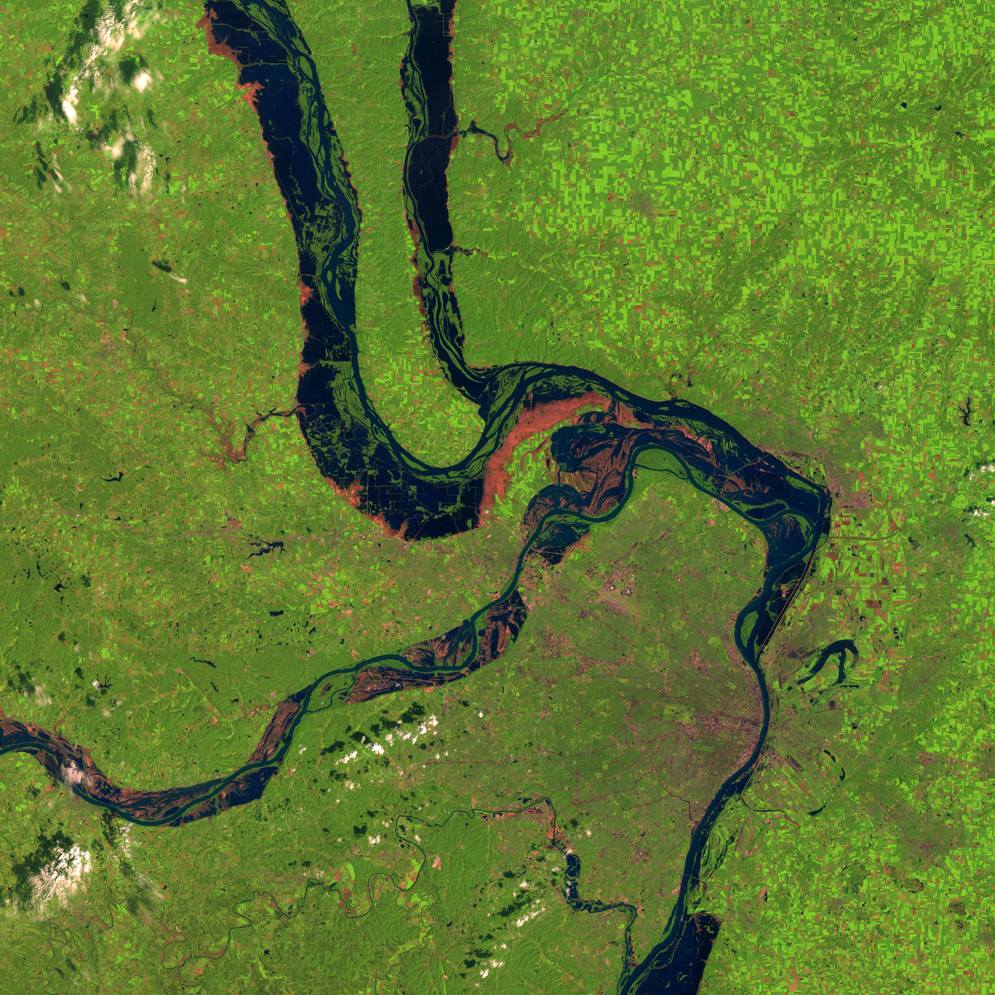
During the first half of 1993, heavy rains in the Midwest United States caused the greatest flood ever recorded on the Upper Mississippi. The Mississippi River remained above flood stage from April through September of that year, and many of the dykes and water control systems along the rivers in this region were overwhelmed. These images from the Landsat-5 Thematic Mapper clearly show the flooded regions near St. Louis. The pink areas near the flooded regions show the scoured land from which the flood waters have receded. A comparison of the image during the flood with an image from a year before clearly shows the preponderance of cultivated fields in the lowland flooded region, evidence that floods and river meanderings have deposited rich soil in these regions in the past.
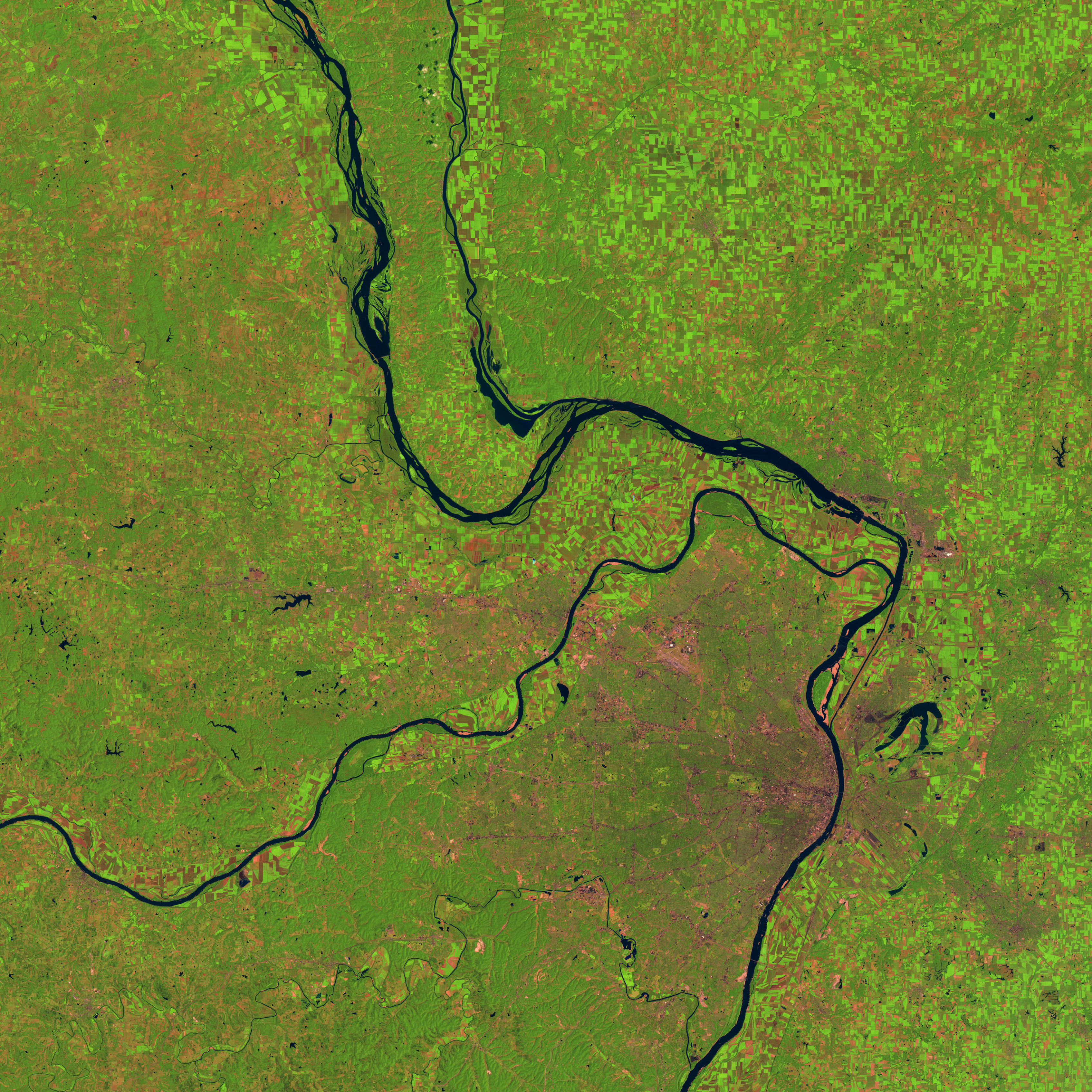

Before and During the Great Mississippi Flood of 1993
For More Information
Visualization Credits
Please give credit for this item to:
NASA/Goddard Space Flight Center Scientific Visualization Studio
NASA/Goddard Space Flight Center Scientific Visualization Studio
Short URL to share this page:
https://svs.gsfc.nasa.gov/3352
Mission:
Landsat
Data Used:
Note: While we identify the data sets used in these visualizations, we do not store any further details nor the data sets themselves on our site.
This item is part of this series:
WMS
Keywords:
DLESE >> Human geography
DLESE >> Hydrology
DLESE >> Natural hazards
GCMD >> Earth Science >> Human Dimensions >> Natural Hazards >> Hydrological Hazards
GCMD >> Earth Science >> Hydrosphere >> Surface Water >> Floods
GCMD >> Earth Science >> Hydrosphere >> Surface Water >> Rivers/Streams
SVS >> Hyperwall
NASA Science >> Earth
GCMD keywords can be found on the Internet with the following citation: Olsen, L.M., G. Major, K. Shein, J. Scialdone, S. Ritz, T. Stevens, M. Morahan, A. Aleman, R. Vogel, S. Leicester, H. Weir, M. Meaux, S. Grebas, C.Solomon, M. Holland, T. Northcutt, R. A. Restrepo, R. Bilodeau, 2013. NASA/Global Change Master Directory (GCMD) Earth Science Keywords. Version 8.0.0.0.0
https://svs.gsfc.nasa.gov/3352
Mission:
Landsat
Data Used:
Landsat-5/TM
This item is part of this series:
WMS
Keywords:
DLESE >> Human geography
DLESE >> Hydrology
DLESE >> Natural hazards
GCMD >> Earth Science >> Human Dimensions >> Natural Hazards >> Hydrological Hazards
GCMD >> Earth Science >> Hydrosphere >> Surface Water >> Floods
GCMD >> Earth Science >> Hydrosphere >> Surface Water >> Rivers/Streams
SVS >> Hyperwall
NASA Science >> Earth
GCMD keywords can be found on the Internet with the following citation: Olsen, L.M., G. Major, K. Shein, J. Scialdone, S. Ritz, T. Stevens, M. Morahan, A. Aleman, R. Vogel, S. Leicester, H. Weir, M. Meaux, S. Grebas, C.Solomon, M. Holland, T. Northcutt, R. A. Restrepo, R. Bilodeau, 2013. NASA/Global Change Master Directory (GCMD) Earth Science Keywords. Version 8.0.0.0.0


