Earth
ID: 3255
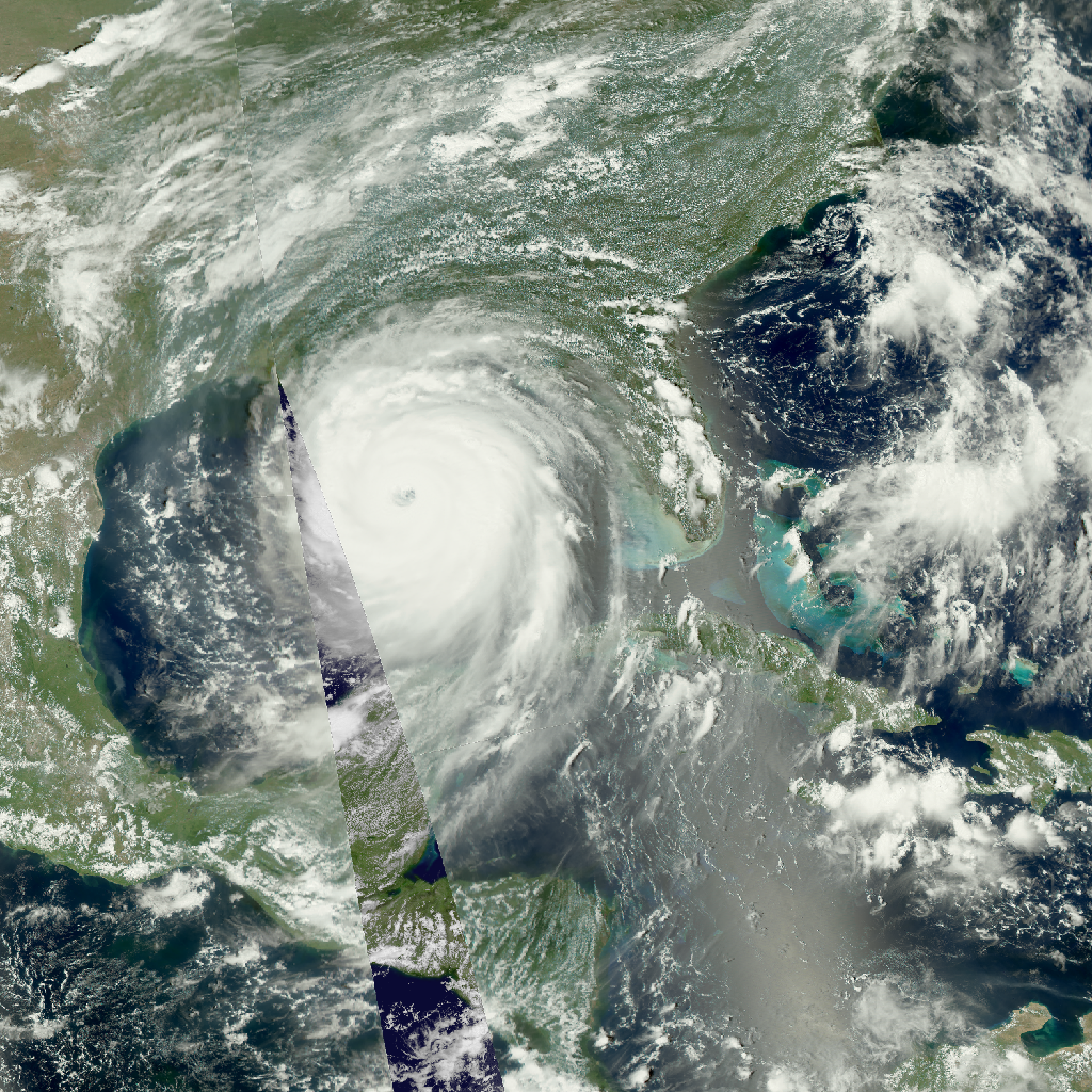
Low earth-orbiting satellites, such as Aqua, usually see any place on Earth no more than once a day. This daily sequence of color images from the MODIS instrument on Aqua shows the Gulf of Mexico during the period of Hurricane Katrina, from August 23 to August 30, 2005. The gaps in the MODIS imagery occur between successive orbits, about 90 minutes apart, and are filled in in this animation using high-resolution visible imagery from GOES-12.
Aqua MODIS Imagery of Hurricane Katrina (WMS)
Visualization Credits
Horace Mitchell (NASA/GSFC): Lead Animator
Gene Feldman (NASA/GSFC): Scientist
Dennis Chesters (NASA/GSFC): Scientist
Gene Feldman (NASA/GSFC): Scientist
Dennis Chesters (NASA/GSFC): Scientist
Please give credit for this item to:
NASA/Goddard Space Flight Center Scientific Visualization Studio
NASA/Goddard Space Flight Center Scientific Visualization Studio
Short URL to share this page:
https://svs.gsfc.nasa.gov/3255
Data Used:
Note: While we identify the data sets used in these visualizations, we do not store any further details nor the data sets themselves on our site.
This item is part of this series:
WMS
Keywords:
SVS >> HDTV
GCMD >> Earth Science >> Atmosphere >> Atmospheric Phenomena >> Hurricanes
GCMD >> Earth Science >> Human Dimensions >> Natural Hazards >> Meteorological Hazards
GCMD >> Earth Science >> Spectral/Engineering >> Visible Wavelengths >> Visible Imagery
SVS >> Hyperwall
SVS >> GOES
NASA Science >> Earth
GCMD keywords can be found on the Internet with the following citation: Olsen, L.M., G. Major, K. Shein, J. Scialdone, S. Ritz, T. Stevens, M. Morahan, A. Aleman, R. Vogel, S. Leicester, H. Weir, M. Meaux, S. Grebas, C.Solomon, M. Holland, T. Northcutt, R. A. Restrepo, R. Bilodeau, 2013. NASA/Global Change Master Directory (GCMD) Earth Science Keywords. Version 8.0.0.0.0
https://svs.gsfc.nasa.gov/3255
Data Used:
Aqua/MODIS
2005-08-23T17:45Z - 2005-08-30T17:45GOES-12/Imager/Visible
2005-08-23T17:45Z - 2005-08-30T17:45This item is part of this series:
WMS
Keywords:
SVS >> HDTV
GCMD >> Earth Science >> Atmosphere >> Atmospheric Phenomena >> Hurricanes
GCMD >> Earth Science >> Human Dimensions >> Natural Hazards >> Meteorological Hazards
GCMD >> Earth Science >> Spectral/Engineering >> Visible Wavelengths >> Visible Imagery
SVS >> Hyperwall
SVS >> GOES
NASA Science >> Earth
GCMD keywords can be found on the Internet with the following citation: Olsen, L.M., G. Major, K. Shein, J. Scialdone, S. Ritz, T. Stevens, M. Morahan, A. Aleman, R. Vogel, S. Leicester, H. Weir, M. Meaux, S. Grebas, C.Solomon, M. Holland, T. Northcutt, R. A. Restrepo, R. Bilodeau, 2013. NASA/Global Change Master Directory (GCMD) Earth Science Keywords. Version 8.0.0.0.0


