Earth
ID: 3250
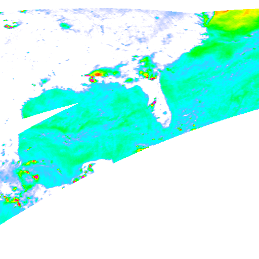
The TMI instrument on the TRMM satellite measures microwaves emitted from the Earth's land and water. By comparing emission from different microwave frequencies, the characteristics of ice and water in the atmosphere can be determined. For example, 85 GHz microwaves are scattered by ice crystals in tropical cyclones, making cyclone rain bands appear 'colder' than the surrounding areas. By comparing 85 GHz temperatures in different polarizations with other frequency band measurements, accurate measurements of rainfall in the atmosphere can be made. This animation shows eight days of global TMI 85 GHz measurements in the Gulf of Mexico during Hurricane Katrina. The hurricane Katrina rainbands clearly show up in these images.
TRMM Microwave Measurements during Hurricane Katrina: Horizontal Polarization
For More Information
Visualization Credits
Please give credit for this item to:
NASA/Goddard Space Flight Center Scientific Visualization Studio
NASA/Goddard Space Flight Center Scientific Visualization Studio
Short URL to share this page:
https://svs.gsfc.nasa.gov/3250
Mission:
Tropical Rainfall Measuring Mission - TRMM
Data Used:
Note: While we identify the data sets used in these visualizations, we do not store any further details nor the data sets themselves on our site.
Dates of Data Used:
2005-08-22T24Z - 2005-08-30T22Z
This item is part of this series:
WMS
Keywords:
GCMD >> Earth Science >> Atmosphere >> Atmospheric Phenomena >> Hurricanes
GCMD >> Earth Science >> Human Dimensions >> Natural Hazards >> Meteorological Hazards
GCMD >> Earth Science >> Spectral/Engineering >> Microwave >> Brightness Temperature
SVS >> Hyperwall
NASA Science >> Earth
GCMD keywords can be found on the Internet with the following citation: Olsen, L.M., G. Major, K. Shein, J. Scialdone, S. Ritz, T. Stevens, M. Morahan, A. Aleman, R. Vogel, S. Leicester, H. Weir, M. Meaux, S. Grebas, C.Solomon, M. Holland, T. Northcutt, R. A. Restrepo, R. Bilodeau, 2013. NASA/Global Change Master Directory (GCMD) Earth Science Keywords. Version 8.0.0.0.0
https://svs.gsfc.nasa.gov/3250
Mission:
Tropical Rainfall Measuring Mission - TRMM
Data Used:
TRMM/TMI/85GHz Brightness Temperature
2005-08-22T24Z - 2005-08-30T22ZDates of Data Used:
2005-08-22T24Z - 2005-08-30T22Z
This item is part of this series:
WMS
Keywords:
GCMD >> Earth Science >> Atmosphere >> Atmospheric Phenomena >> Hurricanes
GCMD >> Earth Science >> Human Dimensions >> Natural Hazards >> Meteorological Hazards
GCMD >> Earth Science >> Spectral/Engineering >> Microwave >> Brightness Temperature
SVS >> Hyperwall
NASA Science >> Earth
GCMD keywords can be found on the Internet with the following citation: Olsen, L.M., G. Major, K. Shein, J. Scialdone, S. Ritz, T. Stevens, M. Morahan, A. Aleman, R. Vogel, S. Leicester, H. Weir, M. Meaux, S. Grebas, C.Solomon, M. Holland, T. Northcutt, R. A. Restrepo, R. Bilodeau, 2013. NASA/Global Change Master Directory (GCMD) Earth Science Keywords. Version 8.0.0.0.0


