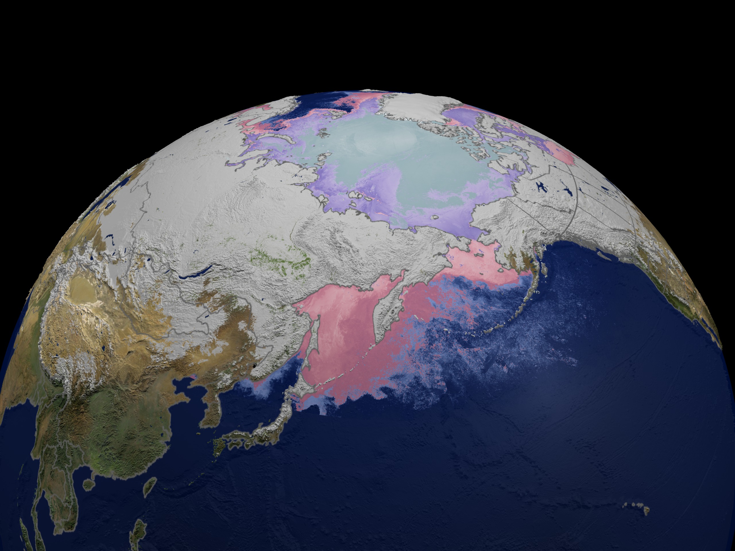
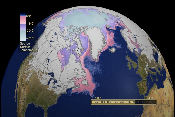
MODIS Daily Global Snow Cover and Sea Ice Surface Temperature as seen in the SIGGRAPH 2005 Electronic Theater
For More Information
Visualization Credits
Greg Shirah (NASA/GSFC): Animator
Marte Newcombe (GST): Animator
Michael Starobin (HTSI): Narrator
Dorothy Hall (NASA/GSFC): Scientist
George Riggs (SSAI): Scientist
Cindy Starr (Global Science and Technology, Inc.): Writer
Dorothy Hall (NASA/GSFC): Writer
George Riggs (SSAI): Writer
Directed by
Dr. Dorothy K. Hall
NASA Goddard Space Flight Center
Produced by
Dr. Horace G. Mitchell
Scientific Visualization Studio
NASA Goddard Space Flight Center
Music
'Luna D'Espagna'
Composed and Performed by
Robert Hitz
Courtesy of Zederwalt Music
Contributors
Randall Jones, Global Science and Technology
Alex Kekesi, Global Science and Technology
Kevin Mahoney, Computer Sciences Corporation
Lori Perkins, NASA
Stuart Snodgrass, Global Science and Technology
Eric Sokolowsky, Global Science and Technology
James W. Williams, Global Science and Technology
Audio Recording by
Fred Kemman, Honeywell Technology Solutions
Audio Mixing by
Mike Velle, Honeywell Technology Solutions
MODIS data courtesy of the
MODIS Science Team
Dr. Vince Salmonson, Team Lead
NASA Goddard Space Flight Center
SeaWiFS data courtesy of the
SeaWiFS Project
and
GeoEye
NOTE: All SeaWiFS images and data presented on this web site are for research and educational use only. All commercial use of SeaWiFS data must be coordinated with GeoEye (NOTE: In January 2013, DigitalGlobe and GeoEye combined to become DigitalGlobe).
Blue Marble MODIS data composite courtesy
of the MODIS Science Team
and the
NASA Earth Observatory
Reto Stockli, Science Systems and Applications, Inc.
https://svs.gsfc.nasa.gov/3180
Mission:
Terra
Data Used:
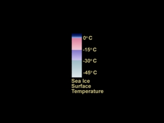
Aqua/MODIS/Sea Ice Extent and Ice Surface Temperature Daily L3 Global 4km EASE-Grid Day (MYD29E1D)
2002/07/01 - 2003/05/31SeaStar/SeaWiFS/Monthly Land Reflectance
2002/07/01 - 2003/05/31NASA/Goddard Space Flight Center, The SeaWiFS Project and GeoEye, Scientific Visualization Studio. NOTE: All SeaWiFS images and data presented on this web site are for research and educational use only. All commercial use of SeaWiFS data must be coordinated with GeoEye (NOTE: In January 2013, DigitalGlobe and GeoEye combined to become one DigitalGlobe.).
Terra/MODIS/Snow Cover Daily L3 Global 0.05Deg CMG (MOD10C1)
2002/07/01 - 2003/05/31Terra and Aqua/MODIS/Blue Marble: Next Generation also referred to as: BMNG
1/1/2004 - 12/31/2004The Blue Marble data is courtesy of Reto Stockli (NASA/GSFC).
This item is part of these series:
Modis Daily Snow and Sea Ice Temperature 2002-2003
Narrated Movies
Keywords:
DLESE >> Cryology
SVS >> HDTV
GCMD >> Earth Science >> Cryosphere >> Sea Ice >> Ice Temperature
GCMD >> Earth Science >> Cryosphere >> Snow/Ice >> Snow Cover
GCMD >> Earth Science >> Hydrosphere >> Snow/Ice >> Snow Cover
GCMD >> Earth Science >> Hydrosphere >> Snow/Ice >> Snow/Ice Temperature
DLESE >> Narrated
SVS >> Voice Over Talent
NASA Science >> Earth
GCMD keywords can be found on the Internet with the following citation: Olsen, L.M., G. Major, K. Shein, J. Scialdone, S. Ritz, T. Stevens, M. Morahan, A. Aleman, R. Vogel, S. Leicester, H. Weir, M. Meaux, S. Grebas, C.Solomon, M. Holland, T. Northcutt, R. A. Restrepo, R. Bilodeau, 2013. NASA/Global Change Master Directory (GCMD) Earth Science Keywords. Version 8.0.0.0.0


