2017 Eclipse Image Collection
http://earthobservatory.nasa.gov/NaturalHazards/view.php?id=90796

A total solar eclipse swept across a 70-mile-wide path of the continental United States for the first time in 99 years. During the rare celestial event, the moon’s shadow moved from west to east creating a diagonal path of totality in 14 states from Oregon to South Carolina. Spectators along the path of totality experienced more than 2 minutes of twilight in the middle of the day. Observers in the remainder of North America, and parts of South America, Africa and Europe saw a partial solar eclipse where the moon covered part of the sun’s disk.
Image Credits: NASA/Rami Daud, Alcyon Technical Services
Credits: "Total Solar Eclipse 2012 Education Resources." Total Solar Eclipse 2012 Education Resources. Astronomical Association of Queensland; Science Teachers Association of Queensland, 2012. Web.
https://www.nasa.gov/image-feature/a-celestial-diamond-ring-nature-s-gift-to-humanity

Credit: Bill Ingalls
http://earthobservatory.nasa.gov/NaturalHazards/view.php?id=90796
Photo Credit: NASA/Aubrey Gemignani

To see the images of Earth every day, go to: https://epic.gsfc.nasa.gov
http://earthobservatory.nasa.gov/NaturalHazards/view.php?id=90796
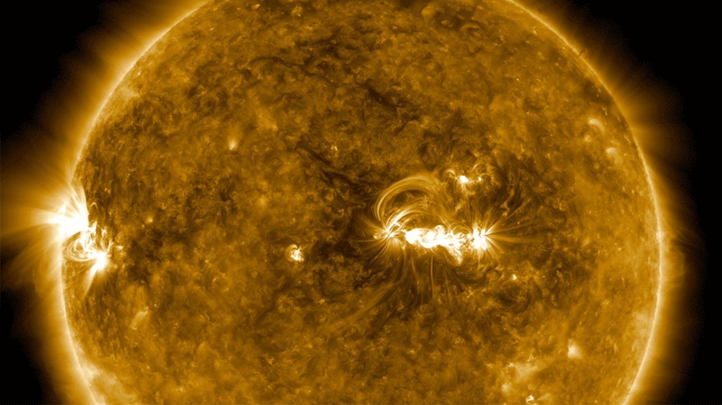
During a total solar eclipse, ground-based telescopes can observe the lowest part of the solar corona in a way that can’t be done at any other time, as the dim corona is normally obscured by the bright light of the Sun. The structure in the ground-based corona image — defined by giant magnetic fields sweeping out from the Sun’s surface — can clearly be seen extending into the outer image from the space-based telescope. The more scientists understand about the lower corona, the more they can understand what causes the constant outward stream of material called the solar wind, as well as occasional giant eruptions called coronal mass ejections.
Credits:
Innermost image: NASA/SDO
Ground-based eclipse image: Jay Pasachoff, Ron Dantowitz, Christian Lockwood and the Williams College Eclipse Expedition/NSF/National Geographic
Outer image: ESA/NASA/SOHO
https://www.nasa.gov/image-feature/goddard/2017/aug-21-solar-eclipse-from-ground-and-space

The Moderate Resolution Imaging Spectroradiometer (MODIS) sensor on Terra captured the data used to make this image using data from different overpasses that was collected at different times.
The right third of the mosaic shows the eastern United States at about 12:10 p.m. Eastern Time (16:10 Universal Time), before the eclipse had begun. The middle part was captured at about 12:50 p.m. Central Time (17:50 Universal Time), when the eclipse was in progress in the center of the country. The left third of the image was collected at about 12:30 p.m. Pacific Time (19:30 Universal Time), after the eclipse had ended.
Credit: NASA Earth Observatory images by Joshua Stevens and Jesse Allen, using MODIS data from the Land Atmosphere Near real-time Capability for EOS (LANCE) and EOSDIS/Rapid Response
http://earthobservatory.nasa.gov/NaturalHazards/view.php?id=90796
The right half of the mosaic shows the eastern United States at about 2:30 p.m. Eastern Time (18:30 Universal Time), when the eclipse had reached the eastern United States.
Credit: NASA Earth Observatory images by Joshua Stevens and Jesse Allen, using MODIS data from the Land Atmosphere Near real-time Capability for EOS (LANCE) and EOSDIS/Rapid Response
http://earthobservatory.nasa.gov/NaturalHazards/view.php?id=90796
SDO sees several lunar transits each year from its orbit 3,000 miles above Earth. However, an eclipse on the ground doesn’t guarantee that SDO will see anything out of the ordinary. On Aug. 21, SDO also saw the Moon briefly pass in front of the Sun at the same time that the Moon’s shadow passed over the eastern United States. SDO only saw 14 percent of the Sun blocked by the Moon, while most U.S. residents saw 60 percent blockage or more.
Credit: NASA/SDO
https://www.nasa.gov/image-feature/goddard/2017/sdos-view-of-the-aug-21-2017-solar-eclipse-animation

Photo Credit: NASA/Bill Ingalls

Image Credit: NASA
https://www.nasa.gov/image-feature/the-eclipse-2017-umbra-viewed-from-space-2

Photo Credit: NASA/Aubrey Gemignani
https://www.nasa.gov/image-feature/the-baileys-beads-effect-during-the-2017-total-solar-eclipse

Image courtesy Jim Jeletic, Hubble Space Telescope deputy project manager, and his son Jordan
https://www.nasa.gov/image-feature/goddard/2017/solar-eclipse-from-greenville-sc
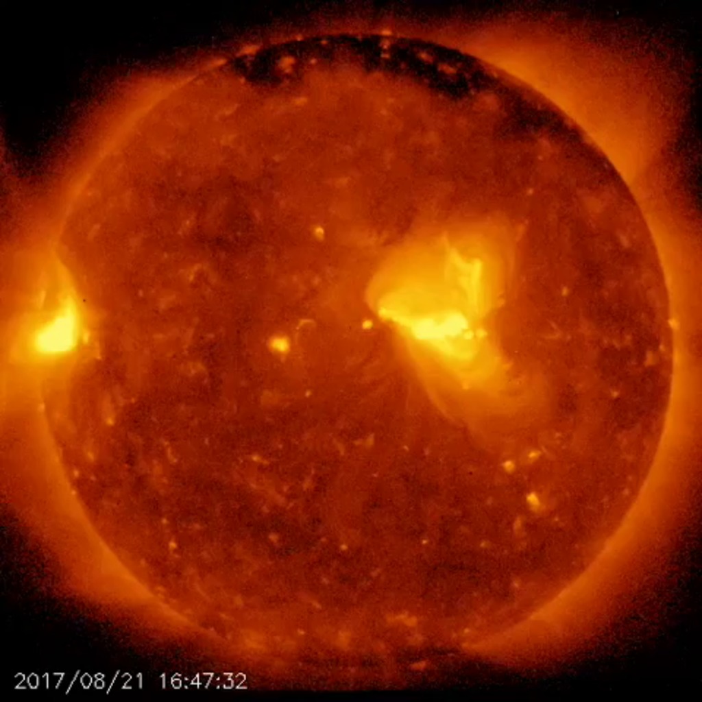
Among its many solar research tasks, the satellite's observation of the eclipse was intended to add new data to ongoing scientific study of the coronal structure in the Sun's polar region and the mechanism of jets of superheated plasma frequently created there. These powerful jets can sometimes erupt 10 million to 12 million miles into space.
The images were taken with Hinode's X-ray telescope (XRT) as it flew above the Pacific Ocean, off the west coast of the United States, at an altitude of approximately 422 miles (680 km).
Hinode is a joint endeavor by the Japan Aerospace Exploration Agency, the National Astronomical Observatory of Japan, the European Space Agency, the United Kingdom Space Agency and NASA.
For more information about Hinode, visit:
https://www.nasa.gov/mission_pages/hinode/index.html
Used Elsewhere In
Credits
NASA's Goddard Space Flight Center
https://svs.gsfc.nasa.gov/30893
Keywords:
SVS >> SOHO
SVS >> Solar Eclipse
SVS >> Hyperwall
SVS >> SDO
SVS >> Eclipse
SVS >> Hinode
SVS >> ISS
SVS >> VIIRS
SVS >> MODIS
NASA Science >> Earth
NASA Science >> Sun
SVS >> DSCOVR


