Earth
ID: 2911
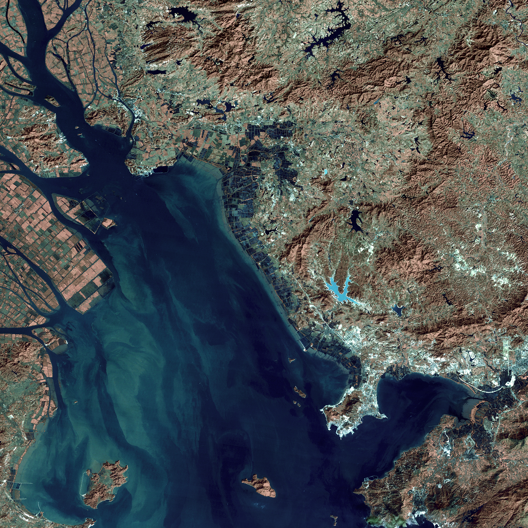
The region around the Pearl River Estuary in southern China experienced rapid urban growth in the 1980s and 1990s. This growth was spurred by the establishment of special government economic zones, particularly in Shenzhen, just to the east of the estuary. Urban areas increased by more than 300% between 1988 and 1996. This growth can be directly assessed by remote sensing measurements from space, particularly by comparing images from the Landsat sensors for the last thirty years. This animation shows nine such images in sequence, from the years 1973, 1975, 1977, 1979, 1988, 1992, 1995, 2000, and 2001.
Urbanization around the Pearl River Estuary in China from 1973 through 2001 (WMS)
For More Information
Visualization Credits
Eric Sokolowsky (GST): Lead Animator
Lori Perkins (NASA/GSFC): Animator
Marte Newcombe (GST): Animator
Horace Mitchell (NASA/GSFC): Animator
Darrel Williams (NASA/GSFC): Scientist
Karen Seto (Stanford University): Scientist
Lori Perkins (NASA/GSFC): Animator
Marte Newcombe (GST): Animator
Horace Mitchell (NASA/GSFC): Animator
Darrel Williams (NASA/GSFC): Scientist
Karen Seto (Stanford University): Scientist
Please give credit for this item to:
NASA/Goddard Space Flight Center Scientific Visualization Studio
NASA/Goddard Space Flight Center Scientific Visualization Studio
Short URL to share this page:
https://svs.gsfc.nasa.gov/2911
Mission:
Landsat
Data Used:
Note: While we identify the data sets used in these visualizations, we do not store any further details nor the data sets themselves on our site.
This item is part of this series:
WMS
Keywords:
DLESE >> Human geography
SVS >> Pearl River
SVS >> Population growth
SVS >> Shenzhen
SVS >> Sprawl
GCMD >> Earth Science >> Human Dimensions >> Environmental Impacts >> Urbanization
GCMD >> Location >> China
SVS >> Hyperwall
SVS >> For Educators
SVS >> Destruction of Habitats
SVS >> Dynamics of Populations
NASA Science >> Earth
GCMD keywords can be found on the Internet with the following citation: Olsen, L.M., G. Major, K. Shein, J. Scialdone, S. Ritz, T. Stevens, M. Morahan, A. Aleman, R. Vogel, S. Leicester, H. Weir, M. Meaux, S. Grebas, C.Solomon, M. Holland, T. Northcutt, R. A. Restrepo, R. Bilodeau, 2013. NASA/Global Change Master Directory (GCMD) Earth Science Keywords. Version 8.0.0.0.0
Places you might have seen this:
'10,000 Shovels: Rapid Urban Growth in China' a documentary film also part of a 87 page teaching module through the Standford Program on International and Cross-Cultural Education available at (http://spice.standford.edu/catalog/list )
https://svs.gsfc.nasa.gov/2911
Mission:
Landsat
Data Used:
Landsat-1/MSS
1973/12/25, 1975/12/24, 1977/02/10Landsat-2/MSS
1975/12/24, 977/02/10Landsat-3/MSS
1979/11/06Landsat-4/TM
1988/12/10, 1992/01/20Landsat-5/TM
1992/01/20, 1995/12/30Landsat-7/ETM+
2000/01/02, 2001/11/20This item is part of this series:
WMS
Keywords:
DLESE >> Human geography
SVS >> Pearl River
SVS >> Population growth
SVS >> Shenzhen
SVS >> Sprawl
GCMD >> Earth Science >> Human Dimensions >> Environmental Impacts >> Urbanization
GCMD >> Location >> China
SVS >> Hyperwall
SVS >> For Educators
SVS >> Destruction of Habitats
SVS >> Dynamics of Populations
NASA Science >> Earth
GCMD keywords can be found on the Internet with the following citation: Olsen, L.M., G. Major, K. Shein, J. Scialdone, S. Ritz, T. Stevens, M. Morahan, A. Aleman, R. Vogel, S. Leicester, H. Weir, M. Meaux, S. Grebas, C.Solomon, M. Holland, T. Northcutt, R. A. Restrepo, R. Bilodeau, 2013. NASA/Global Change Master Directory (GCMD) Earth Science Keywords. Version 8.0.0.0.0
Places you might have seen this:
'10,000 Shovels: Rapid Urban Growth in China' a documentary film also part of a 87 page teaching module through the Standford Program on International and Cross-Cultural Education available at (http://spice.standford.edu/catalog/list )


