Earth
ID: 2899
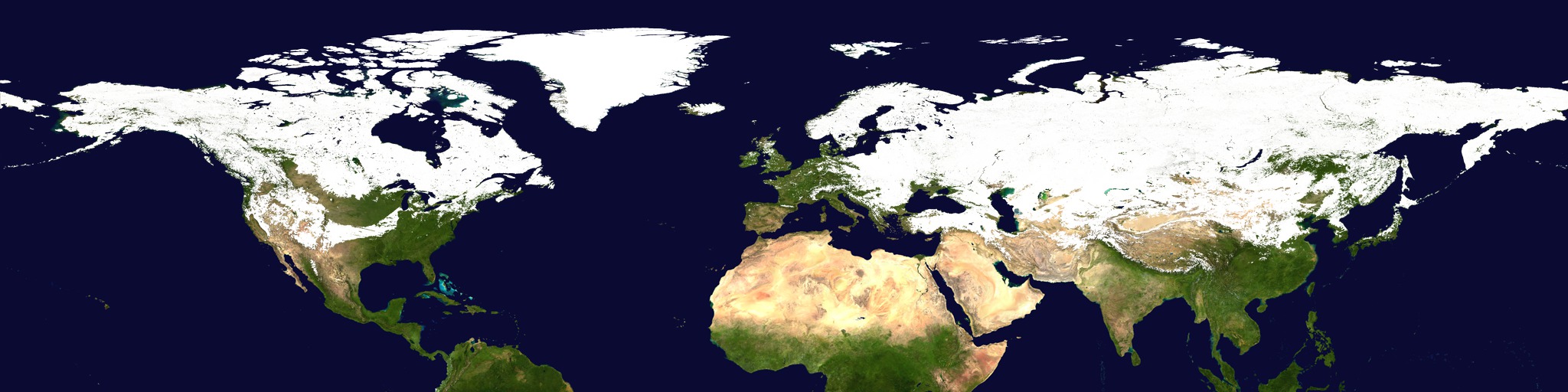
The amount of snow covering the land has both short and long term effects on the environment. From season to season, snow coverage and depth affect soil moisture and water availability, which directly influence agriculture, wildfire occurrences, and drought. In the long term, the part of the Earth's surface covered by snow reflects up to 80 or 90 percent of the incoming solar radiation as opposed to the 10 or 20 percent that uncovered land reflects, and this has important consequences for the Earth's climate. Satellites identify the snow cover precisely by looking at the difference between light reflected off snow in the visible and the infrared wavelengths. This visualization shows the snow cover in the Northern Hemisphere from September, 2002, through June, 2003, as measured by the MODIS instrument on the Terra satellite. Since this instrument cannot measure snow cover through clouds, this visualization designates an area as covered by snow when the instrument takes a valid measurement showing greater than 50% snow coverage in that area. This area is assumed to be snow covered until the instrument takes a valid measurement showing less than 40% snow coverage in that same area. It is possible to see topographic features in the snow cover such as the Rocky Mountains and the Himalayas, and large snow coverage paths from storms that cross the plains of the United States and Russia can also be seen.
Snow Cover over the Northern Hemisphere During the Winter of 2002-2003 (WMS)
For More Information
Visualization Credits
Cindy Starr (Global Science and Technology, Inc.): Lead Visualizer
Eric Sokolowsky (GST): Animator
Dorothy Hall (NASA/GSFC): Scientist
Eric Sokolowsky (GST): Animator
Dorothy Hall (NASA/GSFC): Scientist
Please give credit for this item to:
NASA/Goddard Space Flight Center Scientific Visualization Studio
NASA/Goddard Space Flight Center Scientific Visualization Studio
Short URL to share this page:
https://svs.gsfc.nasa.gov/2899
Mission:
Terra
Data Used:
Note: While we identify the data sets used in these visualizations, we do not store any further details nor the data sets themselves on our site.
This item is part of this series:
WMS
Keywords:
DLESE >> Cryology
SVS >> Seasons
GCMD >> Earth Science >> Cryosphere >> Snow/Ice >> Snow Cover
GCMD >> Earth Science >> Hydrosphere >> Snow/Ice >> Snow Cover
GCMD >> Location >> Northern Hemisphere
SVS >> For Educators
SVS >> Seasons >> Vegetation
NASA Science >> Earth
GCMD keywords can be found on the Internet with the following citation: Olsen, L.M., G. Major, K. Shein, J. Scialdone, S. Ritz, T. Stevens, M. Morahan, A. Aleman, R. Vogel, S. Leicester, H. Weir, M. Meaux, S. Grebas, C.Solomon, M. Holland, T. Northcutt, R. A. Restrepo, R. Bilodeau, 2013. NASA/Global Change Master Directory (GCMD) Earth Science Keywords. Version 8.0.0.0.0
https://svs.gsfc.nasa.gov/2899
Mission:
Terra
Data Used:
Terra/MODIS
2002/09/01 - 2003/06/30This item is part of this series:
WMS
Keywords:
DLESE >> Cryology
SVS >> Seasons
GCMD >> Earth Science >> Cryosphere >> Snow/Ice >> Snow Cover
GCMD >> Earth Science >> Hydrosphere >> Snow/Ice >> Snow Cover
GCMD >> Location >> Northern Hemisphere
SVS >> For Educators
SVS >> Seasons >> Vegetation
NASA Science >> Earth
GCMD keywords can be found on the Internet with the following citation: Olsen, L.M., G. Major, K. Shein, J. Scialdone, S. Ritz, T. Stevens, M. Morahan, A. Aleman, R. Vogel, S. Leicester, H. Weir, M. Meaux, S. Grebas, C.Solomon, M. Holland, T. Northcutt, R. A. Restrepo, R. Bilodeau, 2013. NASA/Global Change Master Directory (GCMD) Earth Science Keywords. Version 8.0.0.0.0


