Earth
ID: 2491
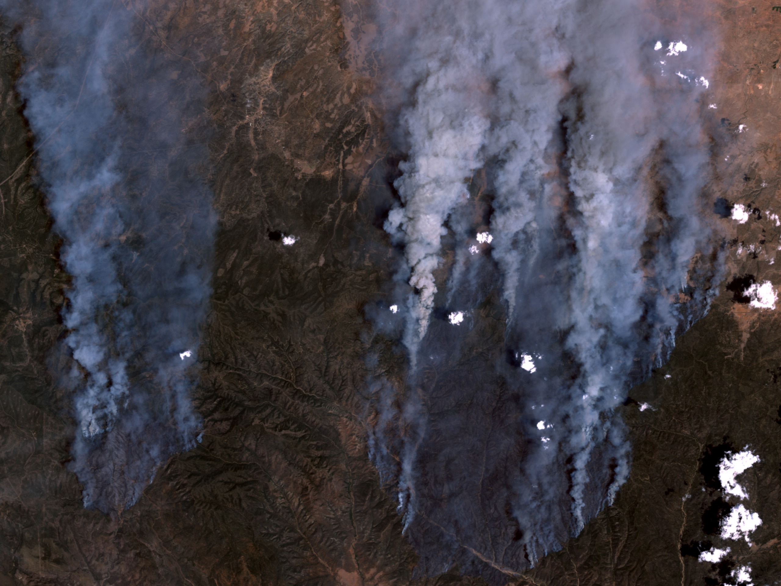
RODEO AND CHEDISKI FIRES IN ARIZONA - On June 21, 2002, the Rodeo and Chediski Fires in east-central Arizona were still two separate fires. This true-color scene from the Enhanced Thematic Mapper Plus aboard the Landsat 7 satellite shows the massive quantities of smoke streaming northward from the fires, which are burning about 100 miles east-northeast of Phoenix. The smaller Chediski Fire is on the right, and the Rodeo Fire is on the left. Over the weekend of June 22, the two fires merged into a single 300,000+ acre blaze.
A Pop-up of the Arizona Fires
Visualization Credits
Please give credit for this item to:
NASA/Goddard Space Flight Center,Scientific Visualization Studio
NASA/Goddard Space Flight Center,Scientific Visualization Studio
Short URL to share this page:
https://svs.gsfc.nasa.gov/2491
Missions:
Landsat
Terra
Data Used:
Note: While we identify the data sets used in these visualizations, we do not store any further details nor the data sets themselves on our site.
This item is part of this series:
Arizona Fires
Keywords:
DLESE >> Natural hazards
GCMD >> Earth Science >> Biosphere >> Ecological Dynamics >> Fire Occurrence
GCMD >> Location >> Arizona
NASA Science >> Earth
GCMD keywords can be found on the Internet with the following citation: Olsen, L.M., G. Major, K. Shein, J. Scialdone, S. Ritz, T. Stevens, M. Morahan, A. Aleman, R. Vogel, S. Leicester, H. Weir, M. Meaux, S. Grebas, C.Solomon, M. Holland, T. Northcutt, R. A. Restrepo, R. Bilodeau, 2013. NASA/Global Change Master Directory (GCMD) Earth Science Keywords. Version 8.0.0.0.0
Places you might have seen this:
GSFC Website http://www.gsfc.nasa.gov/topstory/20020722landsat30.html
https://svs.gsfc.nasa.gov/2491
Missions:
Landsat
Terra
Data Used:
Terra/MODIS
Landsat-7/ETM+
June 21, 2002This item is part of this series:
Arizona Fires
Keywords:
DLESE >> Natural hazards
GCMD >> Earth Science >> Biosphere >> Ecological Dynamics >> Fire Occurrence
GCMD >> Location >> Arizona
NASA Science >> Earth
GCMD keywords can be found on the Internet with the following citation: Olsen, L.M., G. Major, K. Shein, J. Scialdone, S. Ritz, T. Stevens, M. Morahan, A. Aleman, R. Vogel, S. Leicester, H. Weir, M. Meaux, S. Grebas, C.Solomon, M. Holland, T. Northcutt, R. A. Restrepo, R. Bilodeau, 2013. NASA/Global Change Master Directory (GCMD) Earth Science Keywords. Version 8.0.0.0.0
Places you might have seen this:
GSFC Website http://www.gsfc.nasa.gov/topstory/20020722landsat30.html


