Earth
ID: 10967
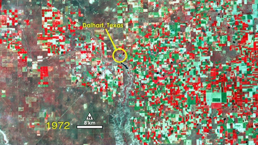
A water-rich polka dot pattern takes over the traditional rectangular patchwork of fields in this 40 year sequence of Landsat images showing the dry Texas panhandle near the town of Dalhart. In this series, vegetation appears red and the bare soil of fallow fields or sparsely vegetated grasslands appear white to green. The blue-gray X near the center of the images marks the town of Dalhart.
Dalhart, Texas 1972-2011
Credits
Matthew R. Radcliff (USRA): Video Editor
Horace Mitchell (NASA/GSFC): Narrator
Matthew R. Radcliff (USRA): Producer
Ellen T. Gray (ADNET Systems, Inc.): Writer
Horace Mitchell (NASA/GSFC): Narrator
Matthew R. Radcliff (USRA): Producer
Ellen T. Gray (ADNET Systems, Inc.): Writer
Please give credit for this item to:
NASA/Goddard Space Flight Center
NASA/Goddard Space Flight Center
Short URL to share this page:
https://svs.gsfc.nasa.gov/10967
Mission:
Landsat
This item is part of these series:
Geophysical Changes Over Time
Narrated Movies
Landsat
Goddard TV Tape:
G2012-047 -- Landsat Change Over Time
Keywords:
SVS >> HDTV
DLESE >> Human geography
SVS >> Landsat
DLESE >> Physical geography
GCMD >> Earth Science >> Biosphere >> Terrestrial Ecosystems >> Agricultural Lands
GCMD >> Earth Science >> Human Dimensions >> Habitat Conversion/Fragmentation >> Irrigation
GCMD >> Earth Science >> Land Surface >> Landscape >> Landscape Pattern
SVS >> Hyperwall
DLESE >> Narrated
NASA Science >> Earth
GCMD keywords can be found on the Internet with the following citation: Olsen, L.M., G. Major, K. Shein, J. Scialdone, S. Ritz, T. Stevens, M. Morahan, A. Aleman, R. Vogel, S. Leicester, H. Weir, M. Meaux, S. Grebas, C.Solomon, M. Holland, T. Northcutt, R. A. Restrepo, R. Bilodeau, 2013. NASA/Global Change Master Directory (GCMD) Earth Science Keywords. Version 8.0.0.0.0

