Global Surface Latent Heat Flux during Hurricane Frances (WMS)
As the Sun's energy reaches the Earth, it is either reflected, absorbed by the clouds, or absorbed by the Earth's surface. The part absorbed by the surface heats the Earth, which causes surface water to evaporate to the air, particularly over oceans or moist land. Similarly, a cold surface causes water to condense from the air onto the land or ocean. Latent heat flux is the amount of energy moving from the surface to the air due to evaporation (positive values) or from the air to the land due to condensation (negative values). This animation shows the latent heat flux for the whole globe from September 1, 2004, through September 5, 2004, during the period of Hurricane Frances in the western Atlantic Ocean and Typhoon Songda in the western Pacific Ocean. The animation clearly shows the evaporation over land only during the heat of the day, while the evaporation over the ocean is continuous throughout the day. The highest positive latent heat flux occurs during hurricanes and typhoons, as these events are powered by the movement of heat energy from the warm ocean to the atmosphere, seen here in Hurricane Frances and Typhoon Songda. Significant negative latent heat flux is somewhat rare and occurs over the ocean only during certain configurations of air and surface conditions.
Global surface latent heat flux from the 0.25 degree resolution fvGCM atmospheric model for the period 9/1/2005 through 9/5/2005.
This product is available through our Web Map Service.
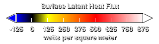
Legend for the surface latent heat flux.
Credits
Please give credit for this item to:
NASA/Goddard Space Flight Center Scientific Visualization Studio
-
Animator
- Horace Mitchell (NASA/GSFC)
-
Scientist
- William Putman (NASA/GSFC)
Release date
This page was originally published on Wednesday, July 27, 2005.
This page was last updated on Sunday, November 12, 2023 at 10:00 PM EST.
Datasets used in this visualization
-
Global Surface Latent Heat Flux [fvGCM]
ID: 384
Note: While we identify the data sets used in these visualizations, we do not store any further details, nor the data sets themselves on our site.