September 04, 2003 - (date of web publication)
Satellite Sees a Smaller Lake Mead
|
Image 1
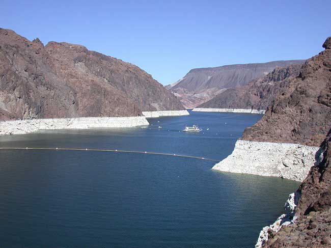
As of July 7, 2003 the lake was 1129 Feet (344.1m) above sea level. Full elevation is at 1221.4 (372.3) feet above sea level, according the Bureau of Reclamations. Lake Mead - photo courtesy of Dr. Ken Dewey, High Plains Regional Climate Center |
It should come as no surprise that many Western movies portray the region as hot, dry, dusty and barren - much of it is. However, the people and plants that do live there still need water, presenting a delivery problem to water officials in the area.
The managers' task becomes all the more challenging when all-too-frequent droughts ravage the area, or when floods plague another. NASA satellite data may help ease the pain, however. By incorporating rainfall amounts and vegetation data into Land Surface Models (LSMs), from NASA and other partner agencies and universities, officials can decide how to allocate water to thirsty regions and how to cope with excess water in drenched parts. The models help officials determine snowpack, soil moisture, and evapotranspiration rates to gauge and predict water levels.
Drought Dries Dam's Lake
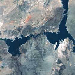
Lake Mead reservoir is nestled between Arizona and Nevada and runs up to the Hoover Dam. The reservoir stores Colorado River water and supplies it to farms, homes and business in Southern Nevada, Arizona, southern California and northern Mexico. Snowmelt from Colorado, Utah, New Mexico and Wyoming provides a majority of the water. Lake Mead is 110 miles (177.0 km) long and 8 miles (12.8 km) wide.
|
|
Image 2
|
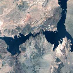
A joint NASA/United States Geological Survey satellite captured dramatic pictures of the dwindling water supplies in the drought-stricken western United States. The Landsat 7 satellite took these images of Lake Mead in May 2000 and 2003, showing clearly less water this year. According to the Bureau of Reclamation, the Colorado Basin is enduring its fourth year of drought, and computer models project water levels will go down another 15 to 20 feet by next year. Despite low water levels, National Park Service Rangers say water recreation has not suffered.
|
|
Image 3
|
|
|
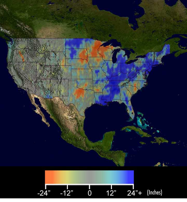
Image 4 Credit: NASA/NASDA |

What A Difference A Year Makes
The image above shows differences in rainfall between spring/summer 2002 and 2003. Red and yellow indicate areas drier in 2003, blue and green show areas wetter in 2003. Most of the West remains short of water through the first half of this year, with several spots worse off than before. On the other hand, the spring deluge in the East shows up as a huge increase over last year's drought conditions. Data represent April 1 - July 31 rainfall amount differences, as measured by the Tropical Rainfall Measuring Mission (TRMM) satellite and other instruments.
For more information contact:
Rani D.Chohan
NASA Goddard Space Flight Center
Greenbelt, MD 20771
phone: 301.286.2483
History of Lake Mead water levels
Bureau of Reclamation Lower Colorado Regional Office
National Drought Mitigation Center
Lake Mead National Recreation Area