EARTH SCIENCE HIGHLIGHTS 2003
Table of Contents
- Top of page
- Wildfire Imaging
- Hurricane Forecasting
- Hurricane Isabel
- Studying Earthquakes
- Arctic Warming
- El Nino Weather Patterns
- Soot and Ice
- Clouds, Ice, Land Elevation
- Patagonia Icefields
- South America Topography
- Dinosaur Crater
- Ozone Hole
- Gravity Model
- Sea Surface Temperatures
- Earth Grows Greener
- Cities Impact Global Change
- Lightning Pollution Link
- Space Shuttle Exhaust
- Eyes on the Earth
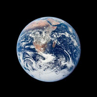
Earth View
Change is inevitable. Predicting and understanding change is science. In 2003, NASA's Earth Science Enterprise made significant progress in providing answers to the question: "How is the Earth changing and what are the consequences for life on Earth?"
From wildfire management to Arctic warming, to developing new tools for earthquake forecasting, NASA's Earth observing satellites provided new and vital information concerning changes in Earth's system.
This web page contains selected media highlights excerpted from video news releases (video files) and web pages that supports NASA's Earth Science Enterprise. The video aired on NASA TV in 2003. Where possible, we provided links to news release, video rundowns, tape numbers, and contacts.
The Earth Science Enterprise mission is to understand and protect our home planet by using our view from space to study the Earth system and improve prediction of Earth system change.
FIRES BELOW, EYES ABOVE: NASA HELPS FIRE MANAGERS KEEP AN EYE ON WHAT'S HOT
Goddard Video Tape Number: G03-039
Item 1 - Click to view Animation
Hayman fire as seen by the Terra satellite.
In the past few years NASA has developed and successfully launched a sophisticated fleet of Earth-observing satellites that have changed the face of wildfire management. Designed to gather revolutionary types of data about our home planet for research purposes, the onboard instruments also are able to monitor wildfires around the clock and around the globe. This constant flow of information allows fire managers to produce daily fire maps that illuminate what's on fire and who's at risk.
The 2003 fire season ushers in significant developments in NASA's contribution to fire management. Along with flight hardware advancements, the space agency is able to provide information that is applicable right now to real-world situations such as fires. Scientists are now testing technology and communication between satellites that will help to automate many Earth-observing tasks and allow experts to focus their attention on the data that matters right now. NASA and its partners expect these new techniques and technologies to help professionals plan for and respond to dangerous fires.
>> Click to go to this story.
A NEW SPIN ON HURRICANES: SATELLITES SENSE RECIPE FOR A NATURAL DISASTER
Goddard Video Tape Number G03-051
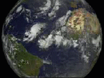
Item 2 - Click to view animation.
Storm clouds over the ocean.
After the first of September, the conditions necessary to trigger a tropical disturbance come together and the Atlantic hurricane season peaks. At the turn of the last century, forecasters only had a vague idea of a hurricane's position, from reports from ships at sea and island stations the storm recently passed. Until a hurricane hit, they couldn't even pinpoint its movements. Thirty years ago, satellites enabled scientists to see hurricanes, yet still they lacked the ability to anticipate the storm's course. These days, with the aid of multiple data sets from a fleet of Earth-observing satellites, scientists more readily understand and predict the formation, intensification, and movement of these super-storms.
>> Click to go to this story.
>> Click to get more information from JPL.
NASA LOOKS AT THE HEAT ENGINE DRIVING HURRICANE ISABEL
Goddard Video Tape Number G03-055
Item 3 - Click to view animation.
Hurricane Isabel.
Scientist use space based tools to look inside Hurricane Isabel and access the storms impact on the United States East Coast. Hurricanes act as heat engines, drawing energy up from warm tropical ocean waters to power the intense winds, powerful thunderstorms, and immense ocean surges. These tools help weather experts determine if a tropical cyclone is likely to strengthen or weaken and how much rain will fall on land.
>> Click to go to this story.
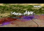
STUDYING EARTHQUAKES FROM SPACE: PROGRESS SINCE NORTHRIDGE
JPL Video Tape Number: AVC-2003-210-1/1

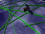
Item 4 - Click to enlarge image.
Artist's concept for a dedicated Interferometric Synthetic Aperture Radar (InSAR) mission.
Nearly 10 years after Los Angeles was shaken by the devastating, magnitude 6.7 Northridge earthquake, scientists at NASA and other institutions say maturing space-based technologies, new ground-based techniques and more complex computer models are rapidly advancing our understanding of earthquakes and earthquake processes.
>> Click to go to this story.
SEASONS OF CHANGE: EVIDENCE OF ARCTIC WARMING GROWS
Goddard Video Tape Number G03-056


Item 5 - Click on images to enlarge images.
Sea ice in 1979 (top), and 2003 (bottom).
Experts have long regarded Earth's polar regions as early indicators for global climate change. But until the last few years, wide ranging, comprehensive research about overall polar conditions has been challenging to conduct. Now a more than twenty-year record of space based measurements has been analyzed by researchers at NASA's Goddard Space Flight Center. Based on their findings, evidence of a warming planet continues to grow.
>> Click to go to this story.
EL NINO, THE USUAL SUSPECT? NORTH ATLANTIC OSCILLATION STIRS UP WINTER WEATHER IN THE EAST
Goddard Video Tape Number G03-013
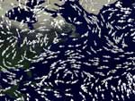
Item 6 - Click to view animation.
North Atlantic anomaly.
2003 was a very cold and snowy winter for the East. El Nino is the usual suspect for odd winter weather. However, the real culprit appears to be hovering over the Northern Atlantic and its called the North Atlantic Oscillation (NAO).
>> Click to go to this story.
THE CASE OF SOOT AND RECEDING ICE
Goddard Video Tape Number G03-069
Item 7 - Click to view animation.
Clean ice (top), and ice with soot (bottom).
Black soot may contribute to melting glaciers and other ice on the planet and eventually a warmer Earth. Traveling potentially thousands of miles from its sources on air currents, this pollution eventually settles out of the air, onto land and into the oceans. On ice and snow, it darkens normally bright surfaces. Just as a white shirt keeps a person cooler in the summer than a black shirt, the vast stretches of polar ice covering much of the planet's top and bottom reflect large amounts of solar radiation falling on the planet's surface, helping regulate Earth's temperature. Soot lowers this albedo, or reflectivity, and the ice retains more heat, leading to increased melting.
>> Click to go to this story.
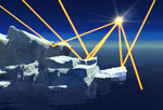
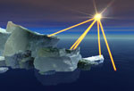
ICESAT SHINES A LIGHT ON OUR WORLD
Goddard Video Tape Number: G03-041
Item 8 - Click to view animation.
Using onboard lasers, GLAS measures the time it takes for a laser signal to reflect back to the satellite off a reflecting object.
NASA’s Ice, Cloud and land Elevation Satellite (ICESat) is sending home spectacular 3-D views of Earth’s clouds, polar ice sheets, mountains, forestlands and even fires, all to help scientists understand how our changing climate will affect life on Earth. The focus objective of the ICESat is to measure the surface elevations of the large ice sheets covering Antarctica and Greenland and how they are changing. The mission also addresses critical issues for the atmosphere and biosphere by detecting cloud and aerosol heights in the atmosphere, dust storms, pollution smoke from forest fires and even tree heights.
>> Click to go to this story.
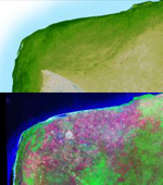
PATOGONIA ICEFIELDS (SRTM)
JPL Video Tape Number: AVC-2003-113-1/1

Item 9 - Click to enlarge image.
Lucia Glacier, Southern Patagonia Icefield. The denuded flanks of the glaciers are another illustration of the rapid retreat of glaciers in this region. Image credit: Andres Rivera.
A new study of the Patagonia Icefields in South America by NASA and Chile's Centro de Estudios Cientificos concludes the ice fields, the largest non-Antarctic ice masses in the Southern Hemisphere, are thinning at a faster pace –contributing to global sea-level rise.
>> Click to go to this story.
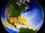
SRTM DATA FOR SOUTH AMERICA
JPL Video Tape Number: AVC-2003-113-1/1

Item 10 - Click to enlarge image.
Image of South America
NASA's Jet Propulsion Laboratory released high resolution topographic map of South America using data collected during the February 2000 Shuttle Radar Topography Mission (SRTM).
>> Click to go to this story.
SRTM MAPS REVEAL DINOSAUR CRATER
JPL Video Tape Number: AVC-2003-051-1/1
 Item 11 - Click to enlarge image.
Evidence of a Crater in Mexico
NASA's Jet Propulsion Laboratory releases a high-resolution topographic map of North America using data collected during the February 2000 Shuttle Radar Topography Mission. SRTM is a cooperative between NASA, the National Imagery and Mapping Agency and German and Italian space agencies.
>> Click to go to this story.
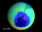
FIRST EVIDENCE OF OZONE HOLE RECOVERY
Goddard
Video Tape Number: G03-054
Item 12 - Click to view animation.
Ozone hole in September 2003.
After a relatively warm Antarctic winter in 2002, the thinning of the protective ozone layer over Antarctica, known as the ozone 'hole,' seems to be as severe as ever in 2003. Due to colder than average temperatures, the 'hole' stretches over an area as large as the North American continent, possibly reaching populated areas of South America and exposing them to ultraviolet rays normally absorbed by ozone. However, scientists have new tools to study this annual phenomenon, and the human-produced compounds that contribute to ozone breakdown are decreasing.
>> Click to go to this story.
GRACE GRAVITY MODEL:
JPL Video Tape Number: AVC-2003-141-1/1

Item 13 - Click to view animated GIF.
GRACE gravity model.
The joint NASA-German Aerospace Center Gravity Recovery and Climate Experiment or GRACE, mission released its first science product: the most accurate map yet created of Earth gravity field. It will help us understand ocean circulation, which strongly influences weather and climate.
>> Click to go to this story.
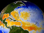
OCEAN SPONGING UP SOME WARMTH OVER NEXT 50 YEARS
Goddard Video Tape Number: G03-052

Item 14 - Click to enlarge image.
Global sea surface temperatures taken from Japan National Space Development Agency's (NASDA) AMSR-E instrument aboard NASA's Aqua spacecraft on August 27, 2003.
NASA's improved global climate computer model, which simulates and projects how the Earth's climate will change, indicates that the oceans have been absorbing heat since 1951 and may continue to absorb more heat from the atmosphere over the next 50 years. This increasing ocean heat storage suggests that global surface temperatures may warm less than previous studies projected, while the ocean acts as a bigger heat sponge. Further, the additional ocean heating may likely change regional climate patterns.
>> Click to go to this story.
GLOBAL GARDEN GROWS GREENER
Goddard Video Tape Number: G03-037

Item 15 - Click to enlarge image.
This map shows productivity increases during the time period in green, while decreases are shown in brown.
Could the Earth be greener than it was two decades ago? A multi-disciplinary study, funded by NASA and the Department of Energy, reports that the Earth has been greening over the last 20 years as the world's climate has changed, and plants have found it easier to grow. The global study states that climate changes have provided extra doses of water, heat and sunlight in areas where one or more of those ingredients may have been lacking. This has allowed plants to flourish in places where climatic conditions have previously limited growth. The research will be published in the June 6, 2003 edition of the journal SCIENCE.
>> Click to go to this story.
URBANIZATION AND CLIMATE: HOW CITIES IMPACT GLOBAL CHANGE AGU 2003
Goddard Video Tape Number: G03-067
Item 16 - Click to view animation.
Image showing how pollution increases summer precipitation.
Satellites help scientists observe major urban areas and their environments around the world, as urbanization can impact processes related to clouds, rainfall, air quality, temperature, and climate. Urbanization may also impact global temperature records, cloud cover, and surface water run-off processes. Recent and future satellites rounding out the NASA’s Earth Observing System will provide an unprecedented capability to measure and link components of urban environments that may signify global change in weather, climate, water resources, air quality, or land use.
>> Click to go to this story.
LIGHTNING HAS A SURPRISING EFFECT ON POLLUTION
Goddard Video Tape Number G03-023

Item 17 - Click to enlarge image.
Image of lightning striking.
Surprising results show scientists that summertime lightning over the United States increases regional pollution 3 to 8 miles above Earth's surface by significant amounts. The lightning-created pollution surpasses those by human activities higher in the atmosphere, in contrast to the larger amounts of manmade urban air pollutants at low levels of the atmosphere. The finding suggests that pollution may lead to more lightning, which leads to more pollution and that during the summertime, a higher frequency of lightning opens the door for the development of more smog in the free troposphere.
>> Click to go to this story.
STUDY FINDS SPACE SHUTTLE EXHAUST CREATES NIGHT-SHINING CLOUDS
Goddard Video Tape Number: G03-027

Item 18 - Click to enlarge image.
Image of noctilucent clouds shining at night.
Observations of noctilucent clouds in the late 20th century have heightened the interest in this curious phenomenon. A new study funded jointly by NASA and the Naval Research Laboratory shows evidence that space shuttle water vapor exhaust can travel to the arctic where it freezes and forms into the Earth's highest clouds called noctilucent clouds. Noctilucent clouds form at an altitude of 51 miles (82 km) in the atmospheric layer directly below the thermosphere called the mesosphere.
>> Click to go to this story.
EYES ON THE EARTH: NASA'S REMOTE SENSING FLEET

Item 19 - Click to enlarge image.
Landsat-7 Satellite
NASA’s Earth observing fleet is growing, and the sum of its capabilities is facilitating extraordinary new research for scientists all over the world. To learn more about a particular satellite, check out this page...
>> Click to go to this story.
FOR ADDITIONAL INFORMATION
This web page is a sampling of the material available on our Earth Science Highlights 2003 video tape.
For copies of the video, contact our tape duplication service. The library number for this tape is G04-008.
Interface Video Systems
1233 20th Street, NW
Washington, DC 20036
Phone - (202) 861-0500
Fax - (202) 785-3216
The duplication cost is minimal.
Lastly, the GODDARD TV page, found at http://www.gsfc.nasa.gov/gtv.html, has more information about what is availble from NASA’s Goddard Space Flight Center.
You’ll find our catalogue there, with information about dozens of other high quality productions, including stories on cutting edge Earth science, spacecraft design, solar physics, Hubble Space Telescope research, and much more.
For more information:
Rani Chohan
NASA Goddard Space Flight Center
Greenbelt, MD 20771
phone: 301.286.2483
Alan Buis
Jet Propulsion Laboratory
Pasadena, CA 91109
phone: 818.354.0474
Wade Sisler
NASA Goddard Space Flight Center
Greenbelt, MD 20771
phone: 301.286.6256