January 10, 2003-(date of web publication)
CHINA HAZE

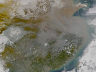
Image 1
Click here for an animation.
NASA satellite image of eastern Asia shows a dense blanket of polluted air over central eastern China -- dense enough that the coastline around Shanghai virtually disappears. The "Asian Brown Cloud" is a toxic mix of ash, acids and airborne particles from car and factory emissions, as well as from low-tech polluters like wood-burning stoves. The Sea-viewing Wide Field-of-view Sensor (SeaWiFS) on board the Orbview 2 satellite captured this image January 10, 2003. Credit: NASA and the MODIS Rapid Response Team (http://rapidfire.sci.gsfc.nasa.gov)

Image 2
Link to Third view giving a closer look at Shanghai
Link to Fourth view giving a closer look at Shenzhen
For more information contact:
Rani Chohan
Goddard Space Flight Center, Greenbelt, MD 20771
(Phone: 301/286-2483)
High Resolution of Image 1 ( 1 MB)
High Resolution of Image 2 (14 MB)
High Resolution of Third View (14 MB)
High Resolution of Fourth View (14 MB)
Click here for an animation of the China haze.