Berlin
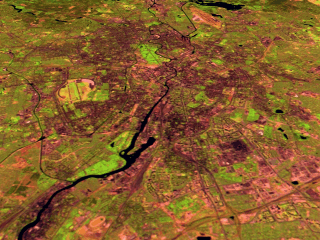
This scene shows the city of Berlin, seen from the eastern side of the city looking west. At the time this Landsat data was collected, Berlin was still divided East and West by the Berlin Wall. The airfield shown somewhat the south of the city is Tempelhof airfield, which was very important during the blockade in 1948/49. The Spree River runs through the center of the city. Just south of the Spree River is a large green area which is Tiergarten Park. The image also shows a brown region in the upper center which is Tegel Airport. Tegel Airport served West Berlin. The Landsat data is shown with shortwave infrared (TM Band 5) displayed as red, near infrared (TM Band 4) as green, and visible green (TM Band 2) as blue. This wide spectral range causes urban features such as concrete buildings and roads to appear as dark grey/black, water as dark blue, while green spaces are vegetation coverage such as grass and trees. |
|
Images: |
|
GIF (56 k) JPEG (245 k) Medium resolution TIFF (3.4 M) High resolution TIFF (12.7 M) |
|
Technical notes: |