VIEW INSIDE MARS REVEALS
RAPID COOLING AND BURIED CHANNELS
A Planet of
Superlatives
Hellas, Olympus Mons, and Valles Marineris
A Short Ride in a Fast Machine
-- A Virtual Tour of Valles Marineris 
View Images and movies
When Hollywood takes us to other planets, we travel in ships of imagination.
But when NASA travels to Mars, the postcards from real spacecraft are written
in scientific data. As shown in the following visualization, NASA 's style
isn 't lacking for flair. These images are derived from precise measurements
taken by the Mars Orbital Laser Altimeter (MOLA). As depicted here, the
viewer travels at a relative altitude of roughly 100 kilometers above the
surface, flying east to west over Valles Marineris. Running more than 4000
kilometers, Valles Marineris is the longest valley network in the solar
system and remains an area of intense interest for those who study Mars.
As it wraps around a vast stretch of the planet 's center, it appears to
drain from the Tharsis and Chryse highlands directly into the northern lowland
regions.
View Valles Marineris Movie
A Bowl Big
Enough for Mt. Everest - The Hellas Impact Basins
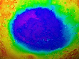
View High Resolution Hellas Impact Basin Image
The Southern Hemisphere is generally higher in relative elevation than the
North with one glaring exception: the Hellas Impact Basin. This enormous
hole in the Red Planet is believed to be the result of a violent collision
by an interstellar body with the surface of Mars billions of years ago. And
it is enormous: Hellas is more than nine kilometers deep and at 2100
kilometers across, it could swallow almost half of the United States. Crater
ejecta stretches out from the center of the bowl more than 4000 kilometers
from the center of the basin, with a ring of blast material lining the bowl
as high as 2 kilometers.
The Grandest Peak in the
Solar System - Olympus Mons
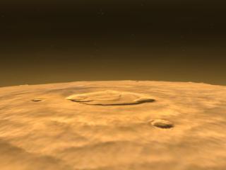
View Images and movies
It 's a mountain so large that a stroll up its side would hardly
cause much of a vertical sensation. But at more than two and a half times
the height of Mt. Everest, Olympus Mons is indisputably the king of the
solar system 's peaks. With no ocean on Mars, there obviously isn 't a sea
level for measuring relative altitudes. Instead, Mars researchers base
elevation measurements on a planetary mean. At the 25-kilometer high summit,
one would easily see the curvature of Mars. In fact, the mountain rises so
far above the mean surface that it actually leaves all but 5% of the Martian
atmosphere behind. The cratered caldera caps a mountain bulge that stretches
almost 550 kilometers east to west, covering an area roughly the size of
Arizona.
Just a few hundred kilometers from Olympus Mons three other gigantic
volcanoes dot the high country known as the Tharsis Bulge. What Mars lacks
in total size is more than compensated by the extremes of its peaks.
View Olympus Mons Movie
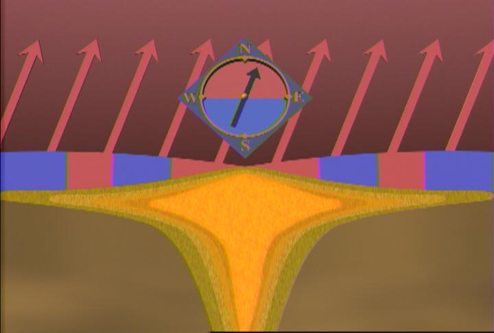
Magnetic Field Oscillations
View Movie
Mars does not show the same kind of magnetic field as Earth. But evidence
collected by the Mars Global Surveyor (MGS) indicates that the planet may
have had a global magnetic field, generated by an internal geological
dynamo. Evidence suggest that the planet's magnetic field reversed
direction, or flipped, several times throughout Martian history as mantle and core conditions
changed. As that dynamo faded, driven by
volcanic activity or meteor collisions or other processes, the crust froze
with faint traces of its magnetic past locked into its structure. As
captured by the MGS magnetometer and electron reflectometer, those traces
appear in invisible, but faintly detectable bands, which magnetically point
in opposite directions, not unlike the magnetic patterns seen in the crust
of the Earth's ocean floors.
View Magnetic Field Movie
The Mars Global Surveyor
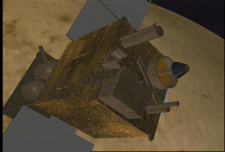
View Images and movies
In the post-Viking lander era, The Mars Global Surveyor (MGS) continues to provide exciting and vital
information about Earth 's neighbor in the post Viking era. By collecting
information about the planet 's topography, composition, atmosphere, and
more, MGS is enabling scientists to build a comprehensive model of Mars in
order to understand it better.
NASA contractor Lockheed Martin built the Mars Global Surveyor at their
facility in Denver. Fully loaded with fuel, the tiny probe weighed only 1060
kilograms (2,342 pounds) on November 7, 1996 when a Delta-7925 rocket
launched it to Mars.
View Mars Global Surveyor Movie
Some Basic Facts about Mars
- Ave. Distance from Sun: 227,940,000 km (1.52 AU)
- Diameter: 6,794 km
- Rotational Period (one day): 24.622 hours
- Mean Surface Temp: -63=BA C
- Orbital Period (one year): 686.98 days
- Moons: 2 (Phobos and Demios)
- Gravity: 38% Earth
THE MARTIAN
NORTH POLE
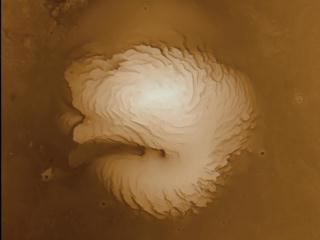
View Images and movies
Both the northern and southern ice caps vary in size as seasons change
on Mars. The permanent northern cap is believed to be made mostly of
frozen water while the southern cap is believed to be made of frozen
carbon dioxide and water. Shown here the northern ice cap extends over a
sizeable portion of the planet's pole, rippling and folding as ice and
snow merge together. It's non-seasonally affected size is several
times greater than its southern counterpart.
View North Pole Movie
Read more about MOLA
For further information, check out the following web sites about ongoing
Mars research:
This multimedia project is the work of a dedicated team of researchers,
animators, and media specialists. A companion video to this web site is
available from NASA-TV. Below are a list of agencies, departments, and
researchers who provided expertise and data for this production:
Please give credit for these images to:
NASA - Goddard Space Flight Center
Scientific Visualization Studio
Television Production NASA-TV/GSFC
The MOLA Instrument and Science Team
Content Preparation and Project Production:
Michael Starobin
Last Revised: February 4, 2019 at 06:02 PM EST
|