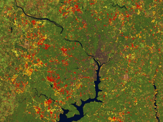
Urban Growth Around Washington D.C. (1973 - 1996)
The scene shown above is a Landsat 1996 image of the Washington D.C. metropolitian area, on top of which has been overlaid measurements of urban growth derived from Landsat data. The first epoch of growth, 1973 - 1985, is shown in red, the second, 1985 - 1990, is orange, and the third, 1990 - 1996, is shown in yellow. Notice the tighter concentration of growth in Montgomery County (northwest of the District of Columbia on the north side of the Potomac River) along the Interstate 270 corridor, whilst the northern Virginia region has grown much more extensively, reflecting different urban development policies.
Technical notes:
|