Earth
ID: 853
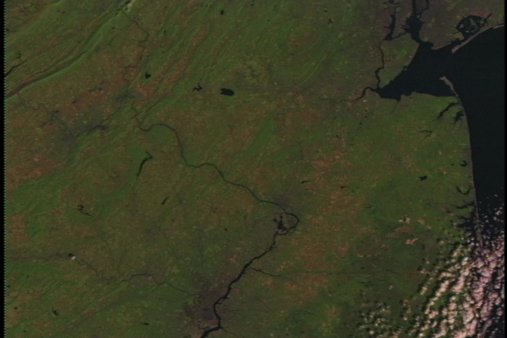
These scenes show the city of Philadelphia as seen by the Landsat Thematic Mapper (TM) instrument. The river running through the city is the Delaware which defines the boundary between New Jersey and Pennsylvania. In the larger city area image, north is approximately up. The river runs south. Just near the top of the image, upstream of the city and where the Delaware River turns west is the New Jersey city of Trenton. The shortwave infrared (TM band 5), infrared (TM band 4), and visible green (TM band 2) channels are displayed in the images as red, green, and blue respectively. In this combination, barren and or recently cultivated land appears red to pink, vegetation appears green, water is dark blue, and artificial structures of concrete and asphalt appear dark gray or black.


Philadelphia Flyby
For More Information
Visualization Credits
Please give credit for this item to:
NASA/Goddard Space Flight Center Scientific Visualization Studio
NASA/Goddard Space Flight Center Scientific Visualization Studio
Short URL to share this page:
https://svs.gsfc.nasa.gov/853
Mission:
Landsat
Data Used:
Note: While we identify the data sets used in these visualizations, we do not store any further details nor the data sets themselves on our site.
This item is part of this series:
USCities
Goddard TV Tape:
G1999-021
Keywords:
DLESE >> Human geography
DLESE >> Hydrology
DLESE >> Physical geography
GCMD >> Location >> Pennsylvania
NASA Science >> Earth
GCMD keywords can be found on the Internet with the following citation: Olsen, L.M., G. Major, K. Shein, J. Scialdone, S. Ritz, T. Stevens, M. Morahan, A. Aleman, R. Vogel, S. Leicester, H. Weir, M. Meaux, S. Grebas, C.Solomon, M. Holland, T. Northcutt, R. A. Restrepo, R. Bilodeau, 2013. NASA/Global Change Master Directory (GCMD) Earth Science Keywords. Version 8.0.0.0.0
https://svs.gsfc.nasa.gov/853
Mission:
Landsat
Data Used:
Landsat-5/TM
1997/10/11This item is part of this series:
USCities
Goddard TV Tape:
G1999-021
Keywords:
DLESE >> Human geography
DLESE >> Hydrology
DLESE >> Physical geography
GCMD >> Location >> Pennsylvania
NASA Science >> Earth
GCMD keywords can be found on the Internet with the following citation: Olsen, L.M., G. Major, K. Shein, J. Scialdone, S. Ritz, T. Stevens, M. Morahan, A. Aleman, R. Vogel, S. Leicester, H. Weir, M. Meaux, S. Grebas, C.Solomon, M. Holland, T. Northcutt, R. A. Restrepo, R. Bilodeau, 2013. NASA/Global Change Master Directory (GCMD) Earth Science Keywords. Version 8.0.0.0.0


