Earth
ID: 761
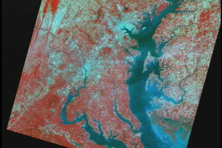
Zoom down to Liberty Reservoir comparing July, 1997 and July, 1999. This animation shows Landsat's view of Maryland's Liberty Reservoir from its normal levels in July of 1997 to its extreme low levels during the drought of 1999.
Maryland Drought: Zoom down to Liberty Reservoir comparing July 1997 and July 1999 (without dates)
Visualization Credits
Please give credit for this item to:
NASA/Goddard Space Flight Center Scientific Visualization Studio
NASA/Goddard Space Flight Center Scientific Visualization Studio
Short URL to share this page:
https://svs.gsfc.nasa.gov/761
Mission:
Landsat
Data Used:
Note: While we identify the data sets used in these visualizations, we do not store any further details nor the data sets themselves on our site.
This item is part of this series:
Landsat 7
Keywords:
DLESE >> Agricultural science
DLESE >> Climatology
SVS >> Drought
DLESE >> Geology
DLESE >> Hydrology
DLESE >> Physical oceanography
GCMD >> Location >> Maryland
NASA Science >> Earth
GCMD keywords can be found on the Internet with the following citation: Olsen, L.M., G. Major, K. Shein, J. Scialdone, S. Ritz, T. Stevens, M. Morahan, A. Aleman, R. Vogel, S. Leicester, H. Weir, M. Meaux, S. Grebas, C.Solomon, M. Holland, T. Northcutt, R. A. Restrepo, R. Bilodeau, 2013. NASA/Global Change Master Directory (GCMD) Earth Science Keywords. Version 8.0.0.0.0
https://svs.gsfc.nasa.gov/761
Mission:
Landsat
Data Used:
Landsat-7/ETM+
1997/07, 1999/07This item is part of this series:
Landsat 7
Keywords:
DLESE >> Agricultural science
DLESE >> Climatology
SVS >> Drought
DLESE >> Geology
DLESE >> Hydrology
DLESE >> Physical oceanography
GCMD >> Location >> Maryland
NASA Science >> Earth
GCMD keywords can be found on the Internet with the following citation: Olsen, L.M., G. Major, K. Shein, J. Scialdone, S. Ritz, T. Stevens, M. Morahan, A. Aleman, R. Vogel, S. Leicester, H. Weir, M. Meaux, S. Grebas, C.Solomon, M. Holland, T. Northcutt, R. A. Restrepo, R. Bilodeau, 2013. NASA/Global Change Master Directory (GCMD) Earth Science Keywords. Version 8.0.0.0.0


