Earth
ID: 4497
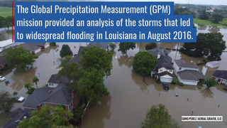
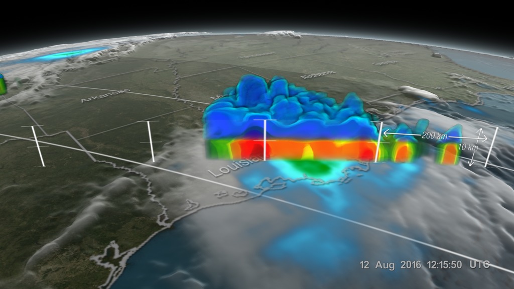
Twice on August 12, 2016 GPM flew over a massive rainstorm that flooded large portions of Louisiana. The flooding was some of the worst ever in the state, resulting in a state of emergency. Tens of thousands of people were evacuated from their homes in the wake of this unprecedented event.
Throughout the course of August 12 (UTC) GPM captured the internal structure of the storm twice and GPM IMERG measured the rainfall accumulation on the ground.
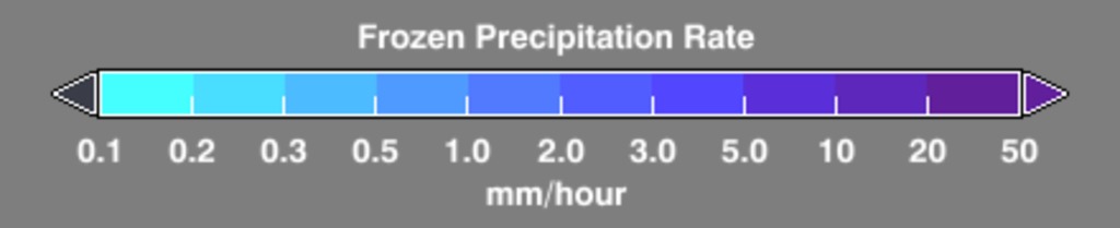
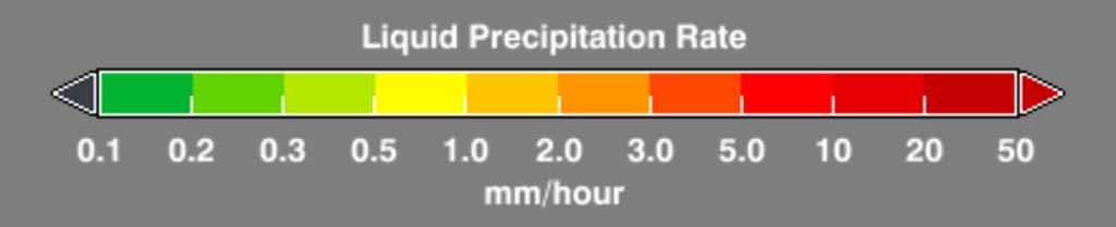
NASA's GPM satellite is designed to measure rainfall using both passive microwave (GMI) and radar (DPR) instruments. DPR can observe 3D structures of radar signals reflected by rain and snow in a narrower swath.
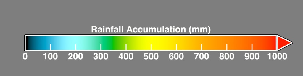
IMERG is a NASA data product that combines data from 12 different satellites into a single seamless map. IMERG covers more of the globe than any previous precipitation data set and is updated every half hour.
GPM sees Louisiana Floods
Throughout the course of August 12 (UTC) GPM captured the internal structure of the storm twice and GPM IMERG measured the rainfall accumulation on the ground.
NASA's GPM satellite is designed to measure rainfall using both passive microwave (GMI) and radar (DPR) instruments. DPR can observe 3D structures of radar signals reflected by rain and snow in a narrower swath.
IMERG is a NASA data product that combines data from 12 different satellites into a single seamless map. IMERG covers more of the globe than any previous precipitation data set and is updated every half hour.
Used Elsewhere In
Related
Visualization Credits
Alex Kekesi (Global Science and Technology, Inc.): Lead Visualizer
Gail Skofronick Jackson (NASA/GSFC): Lead Scientist
George Huffman (NASA/GSFC): Scientist
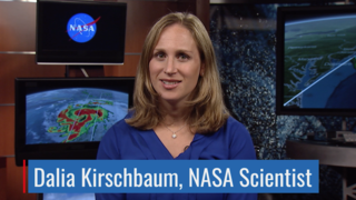
Dalia B Kirschbaum (NASA/GSFC): Scientist
Ryan Fitzgibbons (USRA): Lead Producer
Gail Skofronick Jackson (NASA/GSFC): Lead Scientist
George Huffman (NASA/GSFC): Scientist
Dalia B Kirschbaum (NASA/GSFC): Scientist
Ryan Fitzgibbons (USRA): Lead Producer
Please give credit for this item to:
NASA's Scientific Visualization Studio
NASA's Scientific Visualization Studio
Short URL to share this page:
https://svs.gsfc.nasa.gov/4497
Mission:
Global Precipitation Measurement (GPM)
Data Used:
Note: While we identify the data sets used in these visualizations, we do not store any further details nor the data sets themselves on our site.
This item is part of these series:
Flooding
Floods
GPM Animations
Keywords:
DLESE >> Atmospheric science
DLESE >> Hydrology
DLESE >> Natural hazards
GCMD >> Earth Science >> Atmosphere >> Precipitation >> Rain
GCMD >> Earth Science >> Hydrosphere >> Surface Water >> Floods
SVS >> Hyperwall
NASA Science >> Earth
GCMD >> Earth Science >> Human Dimensions >> Natural Hazards >> Floods
GCMD >> Earth Science >> Terrestrial Hydrosphere >> Surface Water >> Floods
GCMD keywords can be found on the Internet with the following citation: Olsen, L.M., G. Major, K. Shein, J. Scialdone, S. Ritz, T. Stevens, M. Morahan, A. Aleman, R. Vogel, S. Leicester, H. Weir, M. Meaux, S. Grebas, C.Solomon, M. Holland, T. Northcutt, R. A. Restrepo, R. Bilodeau, 2013. NASA/Global Change Master Directory (GCMD) Earth Science Keywords. Version 8.0.0.0.0
https://svs.gsfc.nasa.gov/4497
Mission:
Global Precipitation Measurement (GPM)
Data Used:
CPC (Climate Prediction Center) Cloud Composite
Data Compilation - Climate Prediction Center (CPC) - 8/11/2016 12:00Z - 8/13/2016 12:00Z
Global cloud cover from multiple satellites
GPM/DPR/Ku also referred to as: Volumetric Precipitation data
Observed Data - JAXA - 8/12/2016 2:20Z and 12:21Z
Credit:
Data provided by the joint NASA/JAXA GPM mission.
Data provided by the joint NASA/JAXA GPM mission.
also referred to as: IMERG
Data Compilation - NASA/GSFC - 8/11/2016 12:00Z - 8/13/2016 12:00ZThis item is part of these series:
Flooding
Floods
GPM Animations
Keywords:
DLESE >> Atmospheric science
DLESE >> Hydrology
DLESE >> Natural hazards
GCMD >> Earth Science >> Atmosphere >> Precipitation >> Rain
GCMD >> Earth Science >> Hydrosphere >> Surface Water >> Floods
SVS >> Hyperwall
NASA Science >> Earth
GCMD >> Earth Science >> Human Dimensions >> Natural Hazards >> Floods
GCMD >> Earth Science >> Terrestrial Hydrosphere >> Surface Water >> Floods
GCMD keywords can be found on the Internet with the following citation: Olsen, L.M., G. Major, K. Shein, J. Scialdone, S. Ritz, T. Stevens, M. Morahan, A. Aleman, R. Vogel, S. Leicester, H. Weir, M. Meaux, S. Grebas, C.Solomon, M. Holland, T. Northcutt, R. A. Restrepo, R. Bilodeau, 2013. NASA/Global Change Master Directory (GCMD) Earth Science Keywords. Version 8.0.0.0.0


