Planets and Moons
ID: 4475
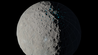
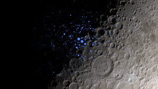
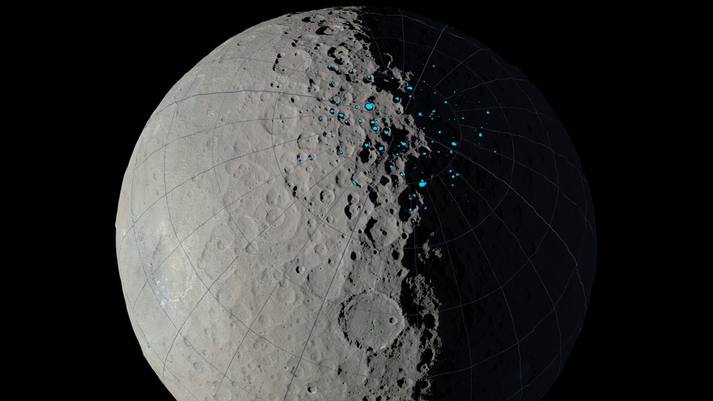
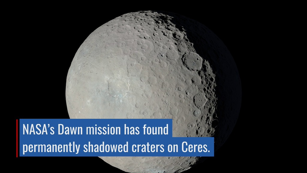
In a new study published in Geophysical Research Letters, lead author Norbert Schorghofer (Institute for Astronomy, University of Hawaii) and six other scientists identify permanently shadowed regions (PSRs) near the north pole of dwarf planet Ceres, using data gathered by the Dawn spacecraft.
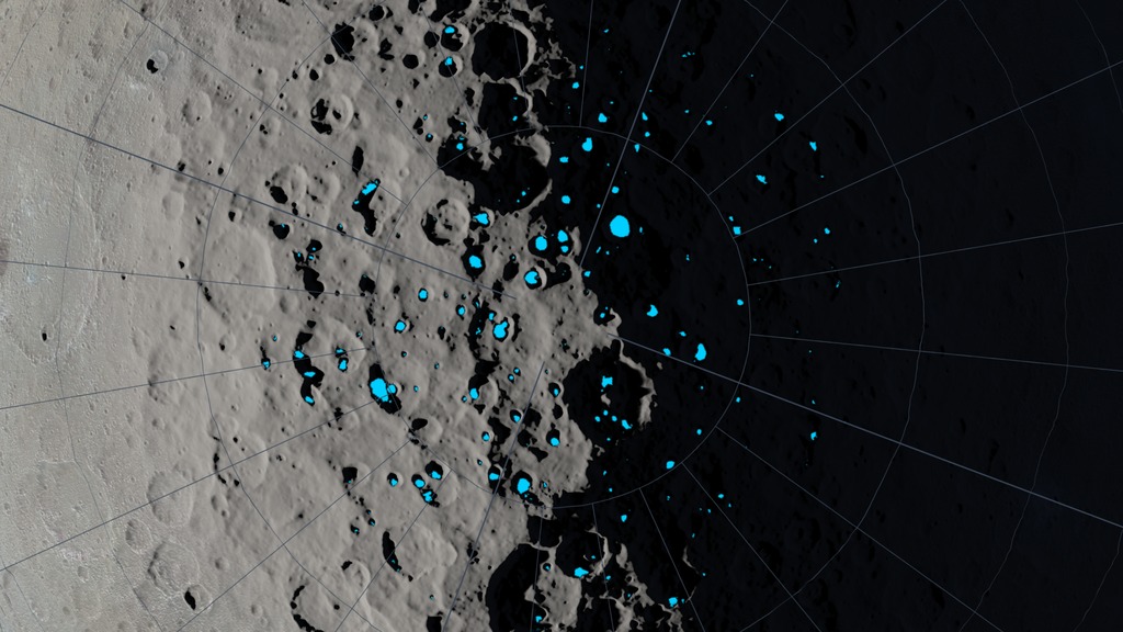
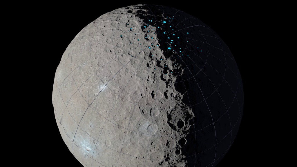
Dawn arrived at Ceres in March of 2015. Since then, its Framing Camera (FC) instrument has photographed the entire surface of Ceres at resolutions down to 62 meters per pixel. Scientists at the German Aerospace Center (Deutsches Zentrum für Luft- und Raumfahrt, or DLR) have used stereo pairs of FC images to create a global digital terrain map (DTM) of the dwarf planet.
The authors of the PSR study used the Ceres DTM and a technique called raytracing to find points on the surface of Ceres that never receive direct sunlight. These PSRs are expected to be cold enough to accumulate water ice over long time spans, and future spacecraft visiting Ceres are likely to find fresh water ice there.

Permanent Shadows on Ceres
Dawn arrived at Ceres in March of 2015. Since then, its Framing Camera (FC) instrument has photographed the entire surface of Ceres at resolutions down to 62 meters per pixel. Scientists at the German Aerospace Center (Deutsches Zentrum für Luft- und Raumfahrt, or DLR) have used stereo pairs of FC images to create a global digital terrain map (DTM) of the dwarf planet.
The authors of the PSR study used the Ceres DTM and a technique called raytracing to find points on the surface of Ceres that never receive direct sunlight. These PSRs are expected to be cold enough to accumulate water ice over long time spans, and future spacecraft visiting Ceres are likely to find fresh water ice there.
Used Elsewhere In
Related
For More Information
Visualization Credits
Ernie Wright (USRA): Lead Visualizer
Erwan M. Mazarico (NASA/GSFC): Scientist
Dan Gallagher (USRA): Producer
Sophia Roberts (USRA): Video Editor
Erwan M. Mazarico (NASA/GSFC): Scientist
Dan Gallagher (USRA): Producer
Sophia Roberts (USRA): Video Editor
Please give credit for this item to:
NASA's Scientific Visualization Studio
NASA's Scientific Visualization Studio
Science Paper:
N. Schorghofer et al., The permanently shadowed regions of dwarf planet Ceres, Geophysical Research Letters, 6 July 2016
Short URL to share this page:
https://svs.gsfc.nasa.gov/4475
Mission:
Dawn
Data Used:
Note: While we identify the data sets used in these visualizations, we do not store any further details nor the data sets themselves on our site.
This item is part of this series:
Narrated Movies
Keywords:
SVS >> Asteroid
SVS >> Elevation data
SVS >> HDTV
SVS >> Hyperwall
SVS >> Planets
SVS >> Shadowed Regions
NASA Science >> Planets and Moons
SVS >> Dawn
Places you might have seen this:
http://onlinelibrary.wiley.com/doi/10.1002/grl.54856/pdf
N. Schorghofer et al., The permanently shadowed regions of dwarf planet Ceres, Geophysical Research Letters, 6 July 2016
Short URL to share this page:
https://svs.gsfc.nasa.gov/4475
Mission:
Dawn
Data Used:
Dawn/Framing Camera/Ceres High Sun Global Color Mosaic also referred to as: Dawn Ceres Color Map
Mosaic
A global color mosaic of the surface of dwarf planet Ceres assembled from Dawn Framing Camera images.
Credit:
German Aerospace Center (DLR)
German Aerospace Center (DLR)
Dawn/Framing Camera/Ceres Global Digital Elevation Map also referred to as: Dawn Ceres DEM
Mosaic
Ceres global elevation data (DEM) developed from stereo photogrammetry using Dawn Framing Camera images.
Credit:
German Aerospace Center (DLR)
German Aerospace Center (DLR)
Dawn/Ceres Permanently Shadowed Regions (North) also referred to as: Ceres PSRs (North)
Model
A map of the permanently shadowed regions near the north pole of dward planet Ceres, derived from the Dawn Ceres DEM.
Credit:
Norbert Schorghofer (Institute for Astronomy, Univ. of HI), Erwan Mazarico (NASA GSFC), et al.
Norbert Schorghofer (Institute for Astronomy, Univ. of HI), Erwan Mazarico (NASA GSFC), et al.
This item is part of this series:
Narrated Movies
Keywords:
SVS >> Asteroid
SVS >> Elevation data
SVS >> HDTV
SVS >> Hyperwall
SVS >> Planets
SVS >> Shadowed Regions
NASA Science >> Planets and Moons
SVS >> Dawn
Places you might have seen this:
http://onlinelibrary.wiley.com/doi/10.1002/grl.54856/pdf


