Planets and Moons
ID: 4444
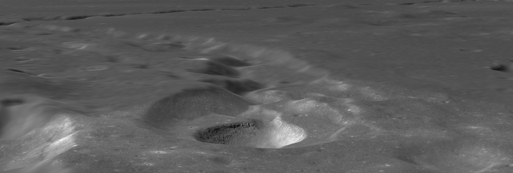
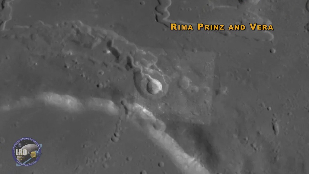
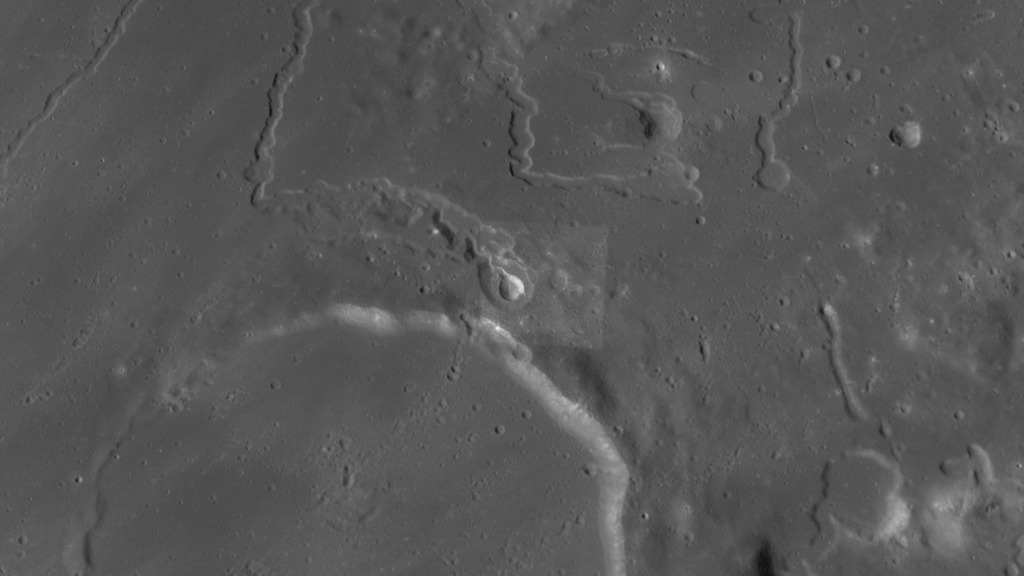
Rima Prinz is a channel (a lunar sinuous rille) carved by lava flow. It lies just north of Prinz crater, about 100 km east of the Aristarchus Plateau in Oceanus Procellarum. The source of the lava is a volcanic depression named Vera. Together they create the appearance of a snake with its head near the rim of Prinz crater and its body stretching some 75 km, first to the west and then turning sharply north.
Vera may have formed as a lava lake fed by multiple eruptions of a fire fountain volcano, similar to Mauna Ulu in Hawaii, but vastly larger. Rima Prinz is a hundred times deeper and ten times longer than similar channels on Earth.
The visualization uses Lunar Reconnaissance Orbiter Camera (LROC) imagery at multiple resolutions to show both small details and global context. It also uses a combination of elevation datasets derived from both LROC narrow-angle camera images and laser altimetry (LOLA). More information about the LROC datasets can be found here. The narrated videos are available in both English and Spanish.
Rima Prinz and Vera
Vera may have formed as a lava lake fed by multiple eruptions of a fire fountain volcano, similar to Mauna Ulu in Hawaii, but vastly larger. Rima Prinz is a hundred times deeper and ten times longer than similar channels on Earth.
The visualization uses Lunar Reconnaissance Orbiter Camera (LROC) imagery at multiple resolutions to show both small details and global context. It also uses a combination of elevation datasets derived from both LROC narrow-angle camera images and laser altimetry (LOLA). More information about the LROC datasets can be found here. The narrated videos are available in both English and Spanish.
Visualization Credits
Ernie Wright (USRA):
Lead Visualizer
David Ladd (USRA):
Producer
Editor
Debra Hurwitz Needham (USRA):
Scientist
Narrator
Patricia C. Flores (Intern):
Narrator (Spanish)
Laurence Schuler (ADNET Systems, Inc.):
Technical Support
Ian Jones (ADNET Systems, Inc.):
Technical Support
Lead Visualizer
David Ladd (USRA):
Producer
Editor
Debra Hurwitz Needham (USRA):
Scientist
Narrator
Patricia C. Flores (Intern):
Narrator (Spanish)
Laurence Schuler (ADNET Systems, Inc.):
Technical Support
Ian Jones (ADNET Systems, Inc.):
Technical Support
Please give credit for this item to:
NASA's Scientific Visualization Studio
NASA's Scientific Visualization Studio
Science Paper:
Hurwitz, D. M., J. W. Head, L. Wilson, and H. Hiesinger (2012), Origin of lunar sinuous rilles: Modeling effects of gravity, surface slope, and lava composition on erosion rates during the formation of Rima Prinz, J. Geophys. Res., 117, E00H14
Short URL to share this page:
https://svs.gsfc.nasa.gov/4444
Mission:
LRO (Lunar Reconnaissance Orbiter)
Data Used:
Note: While we identify the data sets used in these visualizations, we do not store any further details nor the data sets themselves on our site.
This item is part of these series:
The Moon
LRO - Animations
Keywords:
SVS >> Albedo
SVS >> Elevation data
SVS >> HDTV
SVS >> Laser Altimeter
SVS >> Lunar
SVS >> Moon
SVS >> Hyperwall
SVS >> LRO
SVS >> Lunar Reconnaissance Orbiter
SVS >> LOLA
SVS >> LROC
SVS >> Spanish
SVS >> Lunar Topography
SVS >> Lunar Elevation Map
SVS >> Solar System >> Moon >> Lunar Surface
NASA Science >> Planets and Moons
Hurwitz, D. M., J. W. Head, L. Wilson, and H. Hiesinger (2012), Origin of lunar sinuous rilles: Modeling effects of gravity, surface slope, and lava composition on erosion rates during the formation of Rima Prinz, J. Geophys. Res., 117, E00H14
Short URL to share this page:
https://svs.gsfc.nasa.gov/4444
Mission:
LRO (Lunar Reconnaissance Orbiter)
Data Used:
LRO/LOLA/Digital Elevation Map also referred to as: DEM
LRO/LROC/WAC 643nm High Sun Global Mosaic
MosaicLRO/LROC NAC/Stereo DEM
ModelLunar Reconnaissance Orbiter/Wide-Angle Camera/Global Morphological Map also referred to as: LROC WAC Global Morphological Map
MosaicThis item is part of these series:
The Moon
LRO - Animations
Keywords:
SVS >> Albedo
SVS >> Elevation data
SVS >> HDTV
SVS >> Laser Altimeter
SVS >> Lunar
SVS >> Moon
SVS >> Hyperwall
SVS >> LRO
SVS >> Lunar Reconnaissance Orbiter
SVS >> LOLA
SVS >> LROC
SVS >> Spanish
SVS >> Lunar Topography
SVS >> Lunar Elevation Map
SVS >> Solar System >> Moon >> Lunar Surface
NASA Science >> Planets and Moons


