Earth
ID: 4206
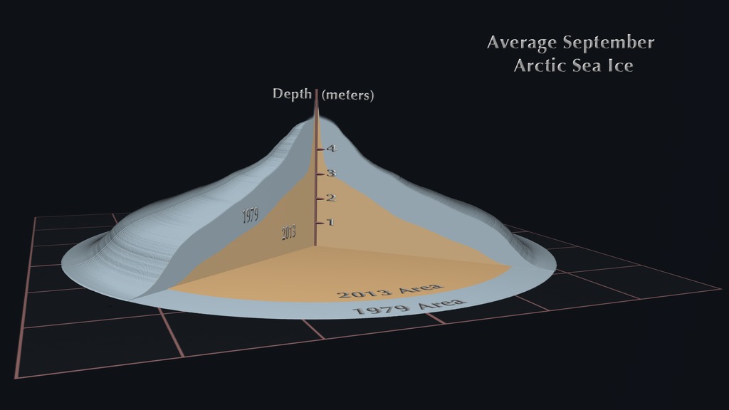
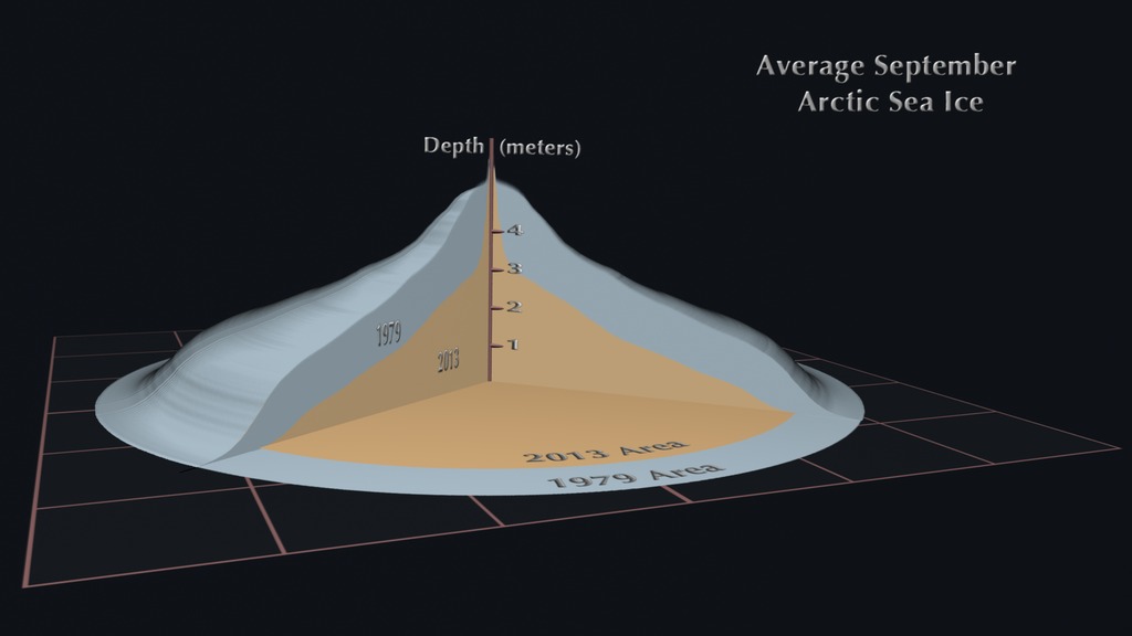
This visualization compares the difference in the area, volume and depth of the average September Arctic sea ice between 1979, shown in blue, and 2013, shown in orange. The data from these two years has been projected onto a circle to provide for easy visual comparison without altering its area or volume. The depth is shown as a histogram that is uniform rotationally around the central axis. Each grid cell of the ground plane is 1,000 kilometers in width, or one million square kilometers per cell. The depth of the sea ice is measured in meters.
This data comes from the Pan-Arctic Ice Ocean Modeling and Assimilation System (PIOMAS). This system combines real observations of the Arctic sea ice from 1979 through the present with data of the ocean and atmosphere to produce a complete picture of the changes in Arctic Sea ice area, thickness, and volume. The sharp spike at the center of the visualization represents the very real phenomenon of thick ice ridges formed by ice dynamics. PIOMAS is more completely described here.

Average September Arctic Sea Ice Comparison: 1979 vs 2013
This data comes from the Pan-Arctic Ice Ocean Modeling and Assimilation System (PIOMAS). This system combines real observations of the Arctic sea ice from 1979 through the present with data of the ocean and atmosphere to produce a complete picture of the changes in Arctic Sea ice area, thickness, and volume. The sharp spike at the center of the visualization represents the very real phenomenon of thick ice ridges formed by ice dynamics. PIOMAS is more completely described here.
Related

Visualization Credits
Cindy Starr (Global Science and Technology, Inc.): Lead Visualizer
Horace Mitchell (NASA/GSFC): Animator
Helen-Nicole Kostis (USRA): Animator
Jefferson Beck (USRA): Producer
Laurence Schuler (ADNET Systems, Inc.): Project Support
Ian Jones (ADNET Systems, Inc.): Project Support
Horace Mitchell (NASA/GSFC): Animator
Helen-Nicole Kostis (USRA): Animator
Jefferson Beck (USRA): Producer
Laurence Schuler (ADNET Systems, Inc.): Project Support
Ian Jones (ADNET Systems, Inc.): Project Support
Please give credit for this item to:
NASA's Scientific Visualization Studio
NASA's Scientific Visualization Studio
Science Paper:
Schweiger, A., R. Lindsay, J. Zhang, M. Steele, H. Stern, Uncertainty in modeled arctic sea ice volume, J. Geophys. Res., doi:10.1029/2011JC007084, 2011
Zhang, J.L. and D.A. Rothrock, Modeling global sea ice with a thickness and enthalpy distribution model in generalized curvilinear coordinates, Mon. Weather Rev., 131, 845-861, 2003
Short URL to share this page:
https://svs.gsfc.nasa.gov/4206
Data Used:
Note: While we identify the data sets used in these visualizations, we do not store any further details nor the data sets themselves on our site.
Keywords:
DLESE >> Cryology
SVS >> HDTV
DLESE >> Physical oceanography
GCMD >> Earth Science >> Cryosphere >> Sea Ice
GCMD >> Earth Science >> Oceans >> Sea Ice
GCMD >> Earth Science >> Cryosphere >> Sea Ice >> Sea Ice Elevation
NASA Science >> Earth
GCMD >> Earth Science >> Climate Indicators >> Cryospheric Indicators >> Sea Ice Elevation
GCMD keywords can be found on the Internet with the following citation: Olsen, L.M., G. Major, K. Shein, J. Scialdone, S. Ritz, T. Stevens, M. Morahan, A. Aleman, R. Vogel, S. Leicester, H. Weir, M. Meaux, S. Grebas, C.Solomon, M. Holland, T. Northcutt, R. A. Restrepo, R. Bilodeau, 2013. NASA/Global Change Master Directory (GCMD) Earth Science Keywords. Version 8.0.0.0.0
Schweiger, A., R. Lindsay, J. Zhang, M. Steele, H. Stern, Uncertainty in modeled arctic sea ice volume, J. Geophys. Res., doi:10.1029/2011JC007084, 2011
Zhang, J.L. and D.A. Rothrock, Modeling global sea ice with a thickness and enthalpy distribution model in generalized curvilinear coordinates, Mon. Weather Rev., 131, 845-861, 2003
Short URL to share this page:
https://svs.gsfc.nasa.gov/4206
Data Used:
also referred to as: PIOMAS Monthly Average Arctic Sea Ice Volume
Model - APL/PSCKeywords:
DLESE >> Cryology
SVS >> HDTV
DLESE >> Physical oceanography
GCMD >> Earth Science >> Cryosphere >> Sea Ice
GCMD >> Earth Science >> Oceans >> Sea Ice
GCMD >> Earth Science >> Cryosphere >> Sea Ice >> Sea Ice Elevation
NASA Science >> Earth
GCMD >> Earth Science >> Climate Indicators >> Cryospheric Indicators >> Sea Ice Elevation
GCMD keywords can be found on the Internet with the following citation: Olsen, L.M., G. Major, K. Shein, J. Scialdone, S. Ritz, T. Stevens, M. Morahan, A. Aleman, R. Vogel, S. Leicester, H. Weir, M. Meaux, S. Grebas, C.Solomon, M. Holland, T. Northcutt, R. A. Restrepo, R. Bilodeau, 2013. NASA/Global Change Master Directory (GCMD) Earth Science Keywords. Version 8.0.0.0.0


