Earth
ID: 4173
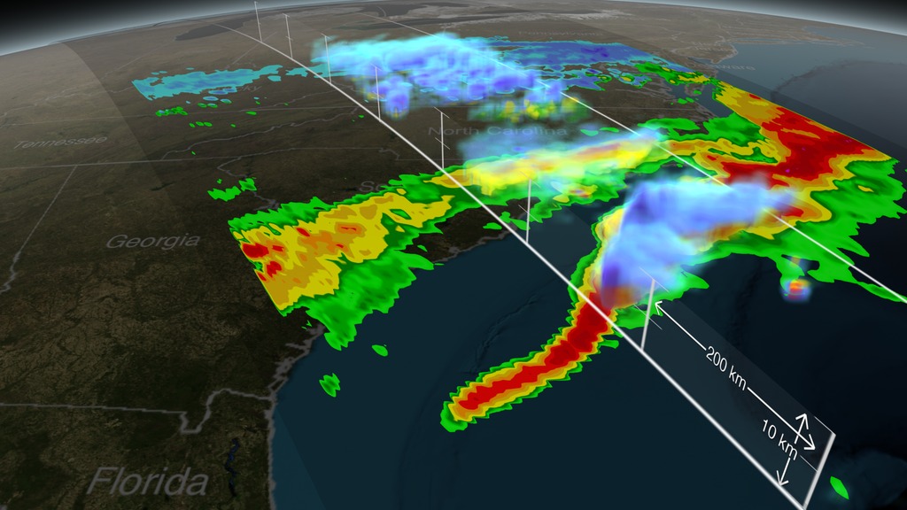
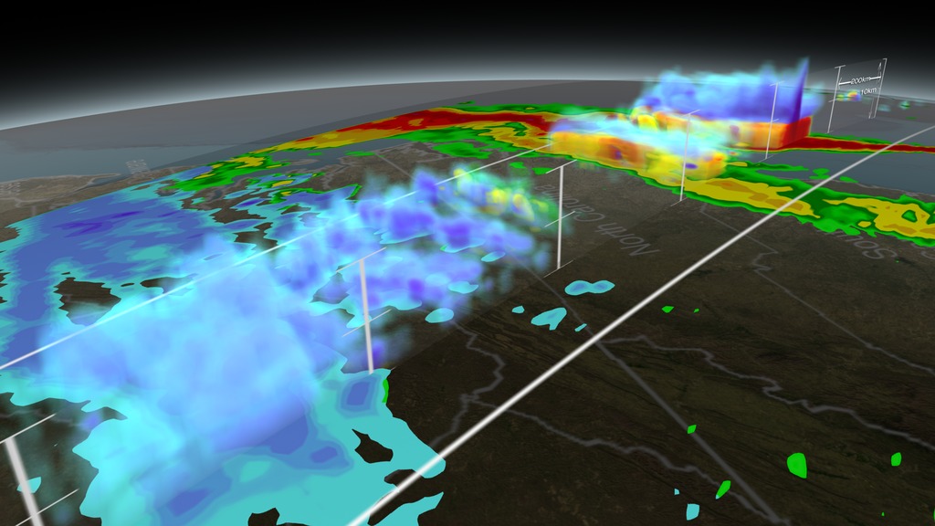
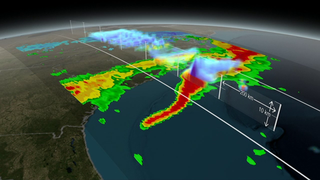
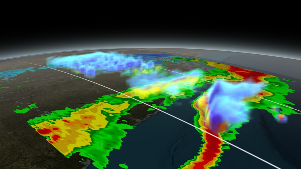
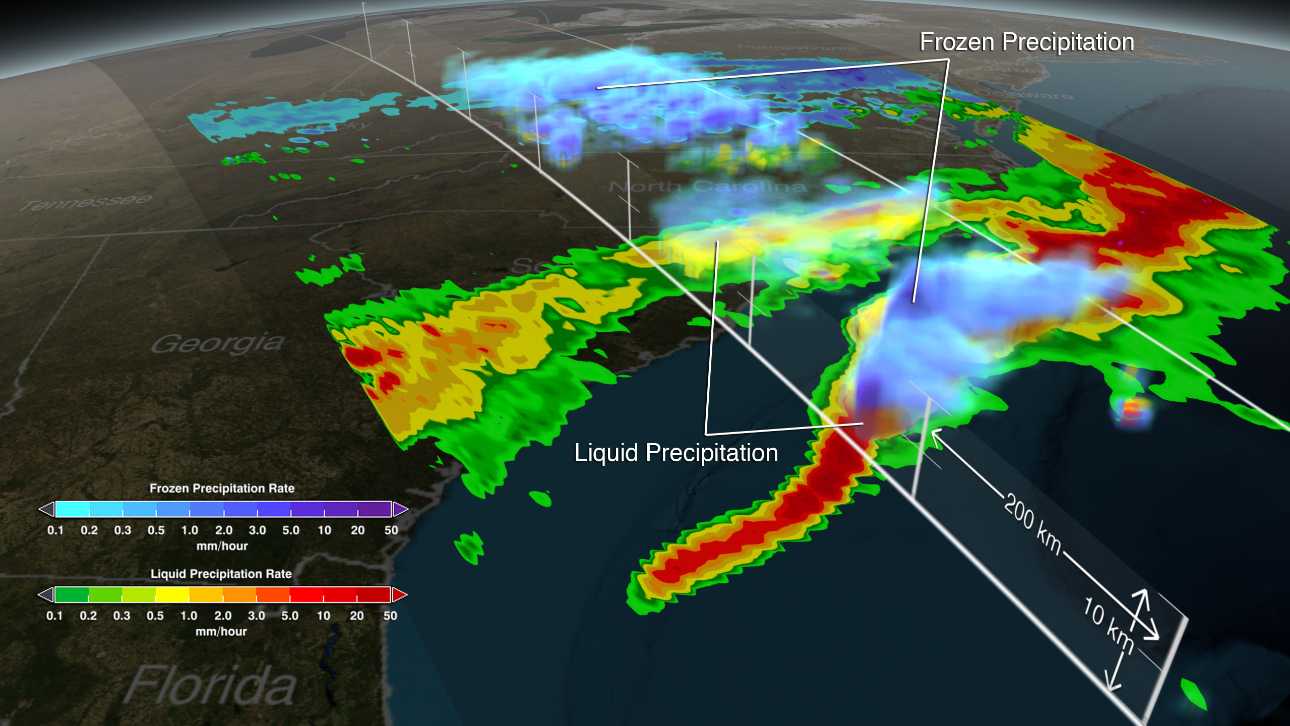
On March 17, 2014 the Global Precipitation Measurement (GPM) mission's Core Observatory flew over the East coast's last snow storm of the 2013-2014 winter season. This was also one of the first major snow storms observed by GPM shortly after it was launched on February 27, 2014.
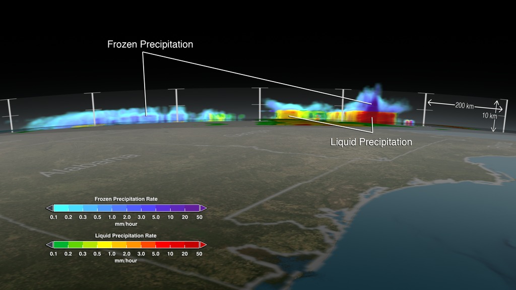
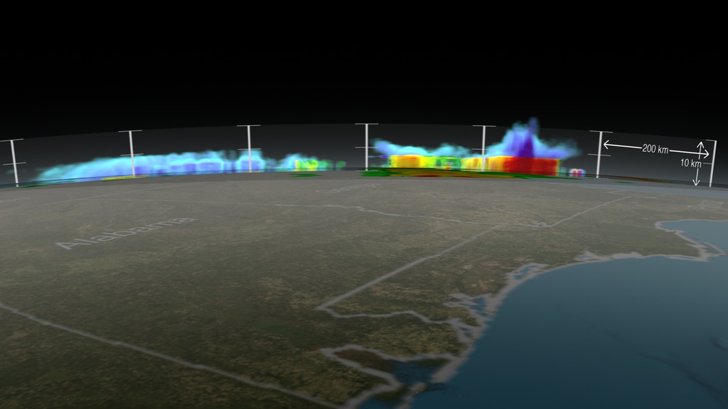
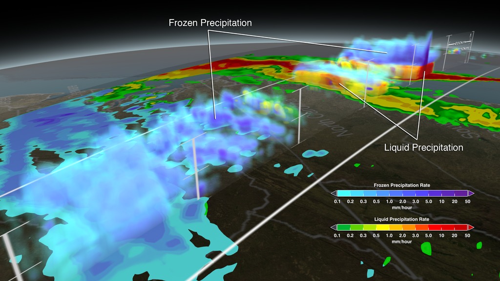
The GPM Core Observatory carries two instruments that show the location and intensity of rain and snow, which defines a crucial part of the storm structure – and how it will behave. The GPM Microwave Imager sees through the tops of clouds to observe how much and where precipitation occurs, and the Dual-frequency Precipitation Radar observes precise details of precipitation in 3-dimensions.
For forecasters, GPM's microwave and radar data are part of the toolbox of satellite data, including other low Earth orbit and geostationary satellites, that they use to monitor tropical cyclones and hurricanes.
The addition of GPM data to the current suite of satellite data is timely. Its predecessor precipitation satellite, the Tropical Rainfall Measuring Mission, is 18 years into what was originally a three-year mission. GPM's new high-resolution microwave imager data and the unique radar data ensure that forecasters and modelers won't have a gap in coverage. GPM is a joint mission between NASA and the Japan Aerospace Exploration Agency. All GPM data products will be released to the public on September 4, 2104. Current and future data sets are available to registered users from NASA Goddard's Precipitation Processing Center website.


GPM Examines East Coast Snow Storm
The GPM Core Observatory carries two instruments that show the location and intensity of rain and snow, which defines a crucial part of the storm structure – and how it will behave. The GPM Microwave Imager sees through the tops of clouds to observe how much and where precipitation occurs, and the Dual-frequency Precipitation Radar observes precise details of precipitation in 3-dimensions.
For forecasters, GPM's microwave and radar data are part of the toolbox of satellite data, including other low Earth orbit and geostationary satellites, that they use to monitor tropical cyclones and hurricanes.
The addition of GPM data to the current suite of satellite data is timely. Its predecessor precipitation satellite, the Tropical Rainfall Measuring Mission, is 18 years into what was originally a three-year mission. GPM's new high-resolution microwave imager data and the unique radar data ensure that forecasters and modelers won't have a gap in coverage. GPM is a joint mission between NASA and the Japan Aerospace Exploration Agency. All GPM data products will be released to the public on September 4, 2104. Current and future data sets are available to registered users from NASA Goddard's Precipitation Processing Center website.
Related
Visualization Credits
Alex Kekesi (Global Science and Technology, Inc.): Lead Animator
Greg Shirah (NASA/GSFC): Animator
Trent L. Schindler (USRA): Animator
Ryan Fitzgibbons (USRA): Producer
Rani Gran (NASA/GSFC): Producer
Gail Skofronick Jackson (NASA/GSFC): Scientist
Dalia B Kirschbaum (NASA/GSFC): Scientist
George Huffman (NASA/GSFC): Scientist
Laurence Schuler (ADNET Systems, Inc.): Project Support
Ian Jones (ADNET Systems, Inc.): Project Support
Robert Simmon (Sigma Space Corporation): Project Support
Jesse Allen (Sigma Space Corporation): Project Support
Ellen T. Gray (ADNET Systems, Inc.): Writer
Please give credit for this item to:
NASA's Scientific Visualization Studio
NASA's Scientific Visualization Studio
Short URL to share this page:
https://svs.gsfc.nasa.gov/4173
Missions:
Global Precipitation Measurement (GPM)
Viking
Data Used:
Note: While we identify the data sets used in these visualizations, we do not store any further details nor the data sets themselves on our site.
This item is part of this series:
GPM Animations
Keywords:
DLESE >> Atmospheric science
DLESE >> Cryology
SVS >> HDTV
DLESE >> Natural hazards
GCMD >> Earth Science >> Atmosphere >> Precipitation
GCMD >> Earth Science >> Cryosphere >> Snow/Ice
GCMD >> Earth Science >> Atmosphere >> Atmospheric Phenomena >> Storms
GCMD >> Earth Science >> Atmosphere >> Precipitation >> Precipitation Rate
GCMD >> Earth Science >> Hydrosphere >> Snow/Ice >> Snow Density
SVS >> Hyperwall
NASA Science >> Earth
GCMD >> Earth Science >> Terrestrial Hydrosphere >> Snow/ice
GCMD >> Earth Science >> Terrestrial Hydrosphere >> Snow/ice >> Snow Density
GCMD keywords can be found on the Internet with the following citation: Olsen, L.M., G. Major, K. Shein, J. Scialdone, S. Ritz, T. Stevens, M. Morahan, A. Aleman, R. Vogel, S. Leicester, H. Weir, M. Meaux, S. Grebas, C.Solomon, M. Holland, T. Northcutt, R. A. Restrepo, R. Bilodeau, 2013. NASA/Global Change Master Directory (GCMD) Earth Science Keywords. Version 8.0.0.0.0
https://svs.gsfc.nasa.gov/4173
Missions:
Global Precipitation Measurement (GPM)
Viking
Data Used:
EO-1/ALI
3/16/14 4:25:55 - 3/17/14 4:49:54GPM/GMI/Surface Precipitation also referred to as: Rain Rates
3/17/14
Credit:
Data provided by the joint NASA/JAXA GPM mission.
Data provided by the joint NASA/JAXA GPM mission.
GPM/DPR/Ku also referred to as: Volumetric Precipitation data
Observed Data - JAXA - 3/17/14
Credit:
Data provided by the joint NASA/JAXA GPM mission.
Data provided by the joint NASA/JAXA GPM mission.
This item is part of this series:
GPM Animations
Keywords:
DLESE >> Atmospheric science
DLESE >> Cryology
SVS >> HDTV
DLESE >> Natural hazards
GCMD >> Earth Science >> Atmosphere >> Precipitation
GCMD >> Earth Science >> Cryosphere >> Snow/Ice
GCMD >> Earth Science >> Atmosphere >> Atmospheric Phenomena >> Storms
GCMD >> Earth Science >> Atmosphere >> Precipitation >> Precipitation Rate
GCMD >> Earth Science >> Hydrosphere >> Snow/Ice >> Snow Density
SVS >> Hyperwall
NASA Science >> Earth
GCMD >> Earth Science >> Terrestrial Hydrosphere >> Snow/ice
GCMD >> Earth Science >> Terrestrial Hydrosphere >> Snow/ice >> Snow Density
GCMD keywords can be found on the Internet with the following citation: Olsen, L.M., G. Major, K. Shein, J. Scialdone, S. Ritz, T. Stevens, M. Morahan, A. Aleman, R. Vogel, S. Leicester, H. Weir, M. Meaux, S. Grebas, C.Solomon, M. Holland, T. Northcutt, R. A. Restrepo, R. Bilodeau, 2013. NASA/Global Change Master Directory (GCMD) Earth Science Keywords. Version 8.0.0.0.0


