Earth
ID: 4044
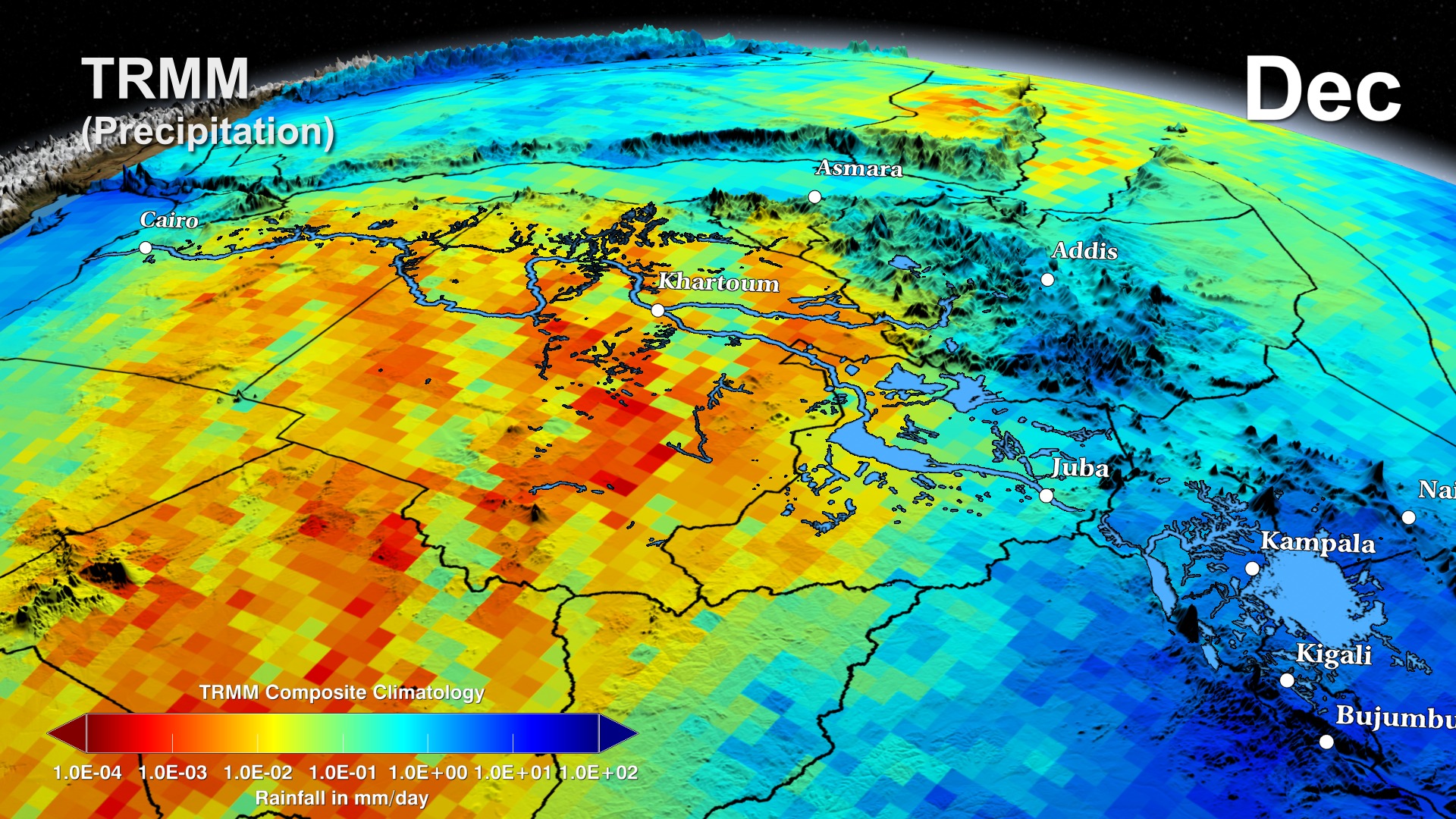
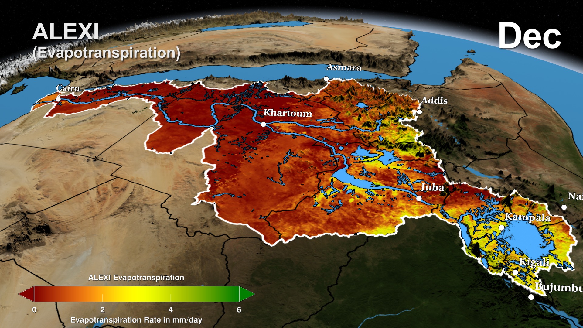
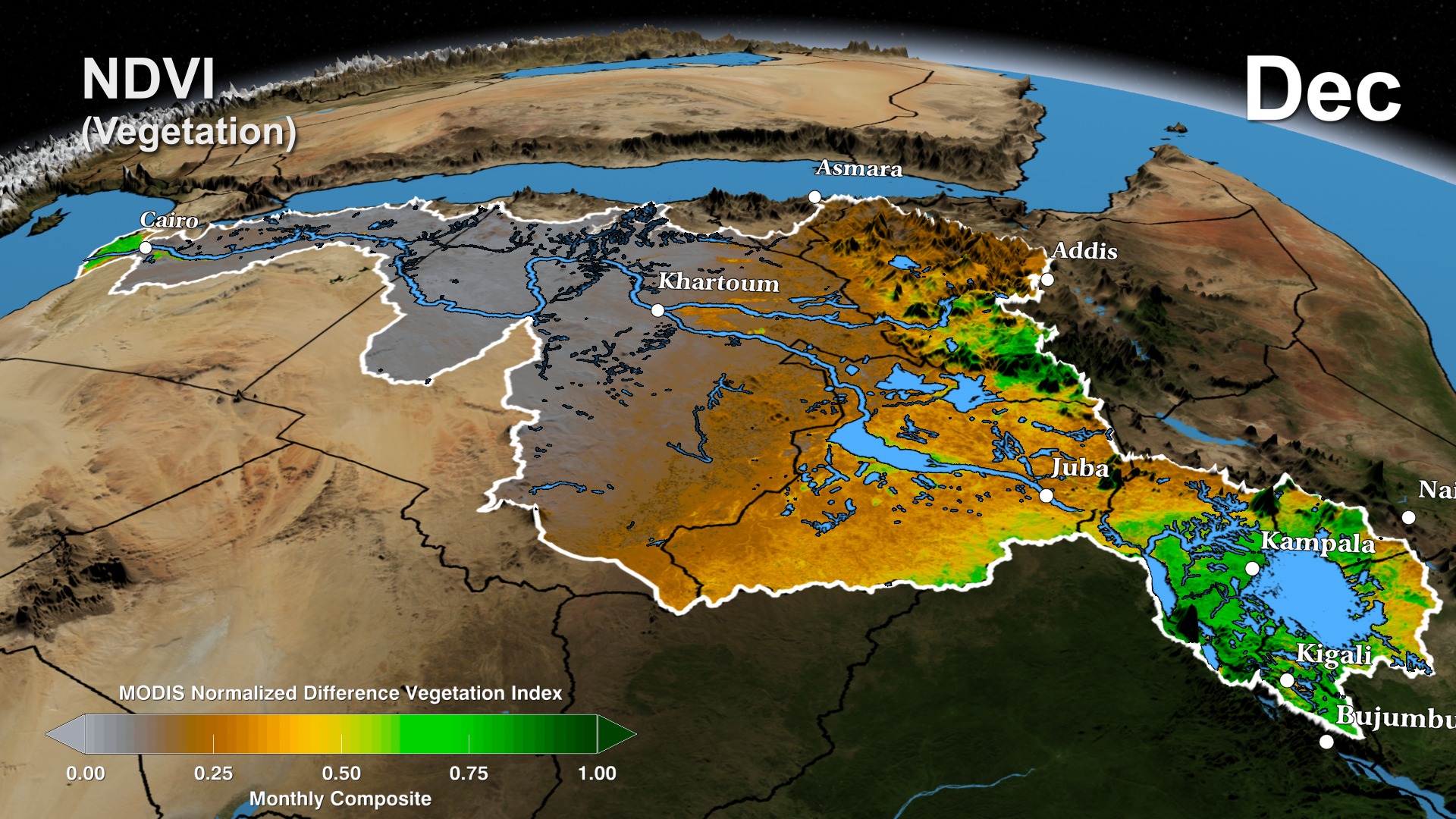
This visualization shows how satellite data and NASA models are being applied to study the hydrology of the Nile basin. The Tropical Rainfall Measurement Mission (TRMM) Multisensor Precipitation Analysis (TMPA) provides three-hourly estimates of rainfall rate across much of the globe. Here we see the seasonal cycle of monthly precipitation derived from TMPA for Africa, including the Nile Basin. The annual migration of the Intertropical Convergence Zone (ITCZ) from the Nile Equatorial Lakes region around Lake Victoria, source of the White Nile, northward into Sudan and the highlands of Ethiopia, headwaters of the Blue Nile, and back is evident in the seasonal cycle in precipitation. This precipitation cycle drives flow through the Nile River system. The Nile basin, however, is intensely evaporative, and the majority of the water that falls as rain leaves the basin as evaporation rather than river flow—either from the humid headwaters regions or from large reservoirs and irrigation developments in Egypt and Sudan. The Atmosphere Land Exchange Inverse (ALEXI) evapotranspiration product, developed by USDA scientists, uses satellite data to map daily evapotranspiration across the entire Nile basin, providing unprecedented information on water consumption. The balance of rainfall and evapotranspiration can be seen in seasonal patterns of soil moisture, as simulated by the NASA Nile Land Data Assimilation System (LDAS), which merges satellite information with a physically-based land surface model to simulate variability in soil moisture—a critical variable for rainfed agriculture and natural ecosystems. Finally, the twin satellites of the Gravity Recovery and Climate Experiment (GRACE) can be used to monitor variability in total water storage, including surface water, soil moisture, and groundwater. The annual cycle in GRACE estimates of water storage anomalies clearly shows the seasonal movement of water storage due to precipitation patterns and the movement of surface waters from headwaters regions into the wetlands of South Sudan and the reservoirs of the lower Nile basin.
The Distributed Water Balance of the Nile Basin
The Nile is the longest river in the world and its basin is shared by 11 countries. Reliable, spatially distributed estimates of hydrologic storage and fluxes can provide critical information for water managers contending with multiple resource demands, a variable and changing climate, and the risk of damaging floods and droughts. NASA observations and modeling systems offer unique capabilities to meet these information needs.
Visualization Credits
Trent L. Schindler (USRA): Lead Animator
Jefferson Beck (USRA): Producer
David Toll (NASA/GSFC): Scientist
Ben Zaitchik (Johns Hopkins University): Scientist
Jefferson Beck (USRA): Producer
David Toll (NASA/GSFC): Scientist
Ben Zaitchik (Johns Hopkins University): Scientist
Please give credit for this item to:
NASA's Goddard Space Flight Center Scientific Visualization Studio
NASA's Goddard Space Flight Center Scientific Visualization Studio
Short URL to share this page:
https://svs.gsfc.nasa.gov/4044
Missions:
Gravity Recovery and Climate Experiment (GRACE)
Terra
Tropical Rainfall Measuring Mission - TRMM
Data Used:
Note: While we identify the data sets used in these visualizations, we do not store any further details nor the data sets themselves on our site.
Keywords:
SVS >> HDTV
SVS >> NDVI
SVS >> Nile
SVS >> Rainfall
SVS >> Water Cycle
GCMD >> Earth Science >> Biosphere >> Vegetation
GCMD >> Earth Science >> Hydrosphere >> Ground Water
GCMD >> Earth Science >> Atmosphere >> Atmospheric Water Vapor >> Evapotranspiration
GCMD >> Location >> Africa
GCMD >> Location >> Middle East
SVS >> Hyperwall
SVS >> GRACE
NASA Science >> Earth
SVS >> LDAS
SVS >> TRMM
SVS >> ALEXI
GCMD keywords can be found on the Internet with the following citation: Olsen, L.M., G. Major, K. Shein, J. Scialdone, S. Ritz, T. Stevens, M. Morahan, A. Aleman, R. Vogel, S. Leicester, H. Weir, M. Meaux, S. Grebas, C.Solomon, M. Holland, T. Northcutt, R. A. Restrepo, R. Bilodeau, 2013. NASA/Global Change Master Directory (GCMD) Earth Science Keywords. Version 8.0.0.0.0
https://svs.gsfc.nasa.gov/4044
Missions:
Gravity Recovery and Climate Experiment (GRACE)
Terra
Tropical Rainfall Measuring Mission - TRMM
Data Used:
Gravity Recovery and Climate Experiment (GRACE)
ALEXI
Data CompilationTerra and Aqua/MODIS/Normalized Difference Vegetation Index (NDVI) also referred to as: NDVI
NASALand Data Assimilation System (LDAS)
Model - NASAKeywords:
SVS >> HDTV
SVS >> NDVI
SVS >> Nile
SVS >> Rainfall
SVS >> Water Cycle
GCMD >> Earth Science >> Biosphere >> Vegetation
GCMD >> Earth Science >> Hydrosphere >> Ground Water
GCMD >> Earth Science >> Atmosphere >> Atmospheric Water Vapor >> Evapotranspiration
GCMD >> Location >> Africa
GCMD >> Location >> Middle East
SVS >> Hyperwall
SVS >> GRACE
NASA Science >> Earth
SVS >> LDAS
SVS >> TRMM
SVS >> ALEXI
GCMD keywords can be found on the Internet with the following citation: Olsen, L.M., G. Major, K. Shein, J. Scialdone, S. Ritz, T. Stevens, M. Morahan, A. Aleman, R. Vogel, S. Leicester, H. Weir, M. Meaux, S. Grebas, C.Solomon, M. Holland, T. Northcutt, R. A. Restrepo, R. Bilodeau, 2013. NASA/Global Change Master Directory (GCMD) Earth Science Keywords. Version 8.0.0.0.0


