A newer version of this visualization is available.
Deep Star Maps
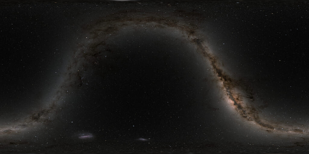
This set of star maps was created by plotting the position, brightness, and color of just over 100 million stars from the Bright Star, Tycho-2, and UCAC3 star catalogs. The constellation boundaries are those established by the International Astronomical Union in 1930. The constellation figures also come from the IAU, although they're not official.
The maps are presented in plate carrée projections using either celestial (J2000 geocentric right ascension and declination) or galactic coordinates. They are designed for spherical mapping in animation software. The oval shapes near the top and bottom of the star maps are not galaxies. The distortion of the stars in those parts of the map is just an effect of the projection.
The celestial coordinate mapping will be the more useful one for animation, since camera rotations in the software will correspond in a straightforward way to the right ascension and declination in astronomy references. The galactic coordinate mapping works as a standalone image showing the edge-on view of our home galaxy, from the inside.
The animation demonstrates the use of the maps in a tour of the sky. The tour starts at W-shaped Cassiopeia, then heads south through Perseus to the winter constellation of Orion the Hunter and the Hyades and Pleiades star clusters in Taurus. It moves southeast past Orion's canine companion and its star, Sirius, brightest in the sky, eventually pausing at the rich southern hemisphere portion of the Milky Way in Carina and Crux, the Southern Cross.
East of the Cross, in Centaurus, is the binary star Alpha Centauri, at 4.4 light-years the naked-eye star system nearest to the Sun. Also visible as a fuzzy spot near the top of the frame is the globular cluster Omega Centauri. The number of stars used to draw the star maps is large enough to reveal many globular and open star clusters as well as the Large and Small Magellanic Clouds.
After passing near the celestial south pole, the tour moves north along the Milky Way to the center of our galaxy near the teapot in Sagittarius. The tour veers northwest from there, finally stopping at the familiar Big Dipper or Plough asterism in Ursa Major.
This is an update to entry 3572.
A short tour of the sky demonstrating the use of the star maps.

The star map in celestial coordinates, at three resolutions.

A celestial coordinate grid.

Official IAU constellation boundaries in celestial coordinates.

Constellation figures in celestial coordinates.

The star map in galactic coordinates.

The official IAU constellation boundaries in galactic coordinates.

Constellation figures in galactic coordinates.
Credits
Please give credit for this item to:
NASA/Goddard Space Flight Center Scientific Visualization Studio. Constellation figures based on those developed for the IAU by Alan MacRobert of Sky and Telescope magazine (Roger Sinnott and Rick Fienberg).
-
Animators
- Ernie Wright (USRA)
- Tom Bridgman (Global Science and Technology, Inc.)
Release date
This page was originally published on Tuesday, January 17, 2012.
This page was last updated on Wednesday, May 3, 2023 at 1:53 PM EDT.
Datasets used
-
Bright Star Catalogue (Yale Bright Star Catalogue)
ID: 285This dataset can be found at: http://tdc-www.harvard.edu/catalogs/bsc5.html
See all pages that use this dataset -
Tycho Catalogue (Tycho 2 Catalogue) [Hipparcos: Telescope]
ID: 550This dataset can be found at: http://archive.eso.org/ASTROM/
See all pages that use this dataset -
UCAC3 (Catalog) [U.S. Naval Observatory: Third CCD Astrograph]
ID: 724
Note: While we identify the data sets used on this page, we do not store any further details, nor the data sets themselves on our site.
