Earth
ID: 3669
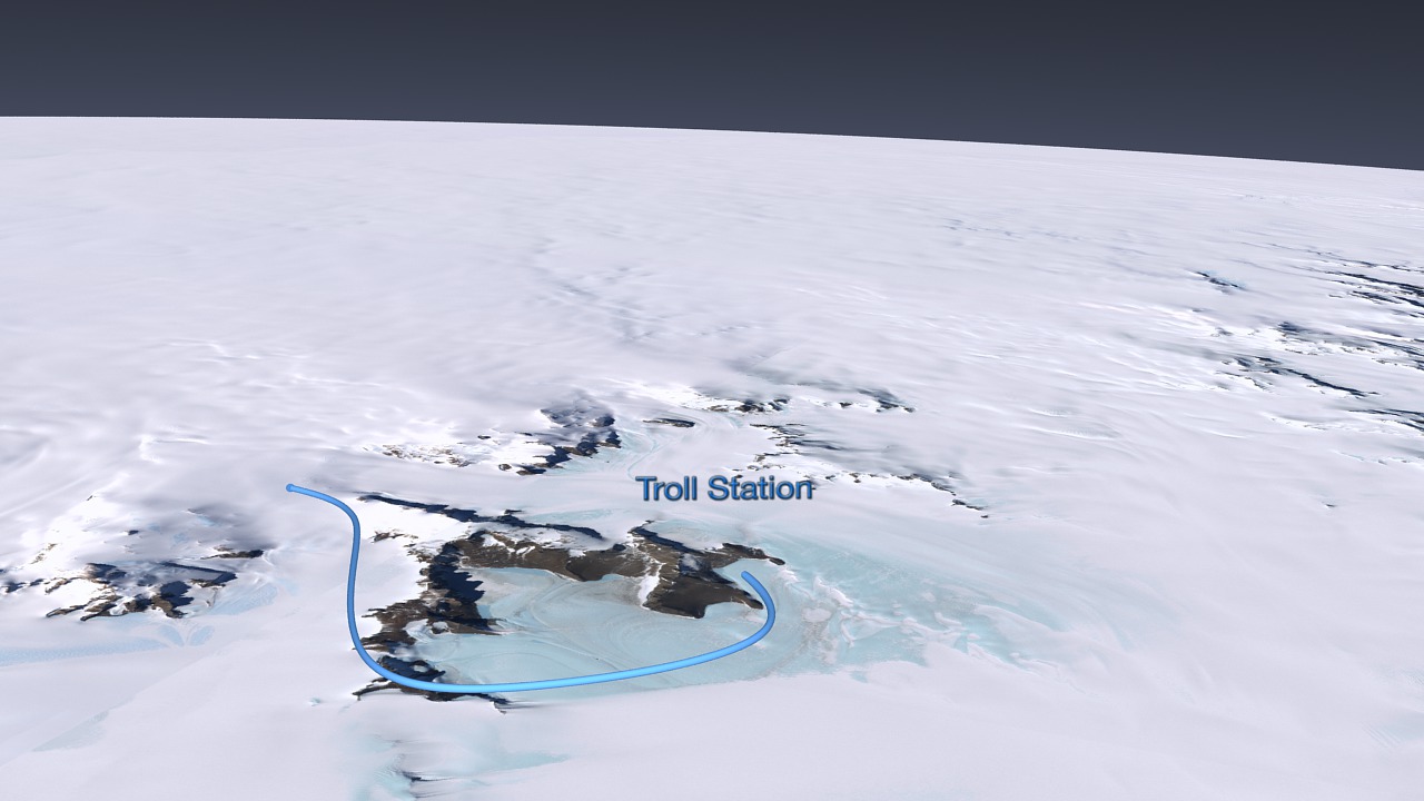
A massive, largely unexplored region, the East Antarctic ice sheet looms large in the global climate system, yet relatively little is known about its climate variability or the contribution it makes to sea level changes. The field expedition for this international partnership involves scientific investigations along two overland traverses in East Antarctica: one going from the Norwegian Troll Station to the United States South Pole Station in 2007-2008; and a return traverse by a different route in 2008-2009. This project will investigate climate change in East Antarctica.


Norwegian-U.S. Scientific Traverse of East Antarctica
One of the most pressing environmental issues of our time is the need to understand the mechanisms of current global climate change and the associated impacts on global economic and political systems. In order to predict the future with confidence, we need a clear understanding of past and present changes in the Polar Regions and the role these changes play in the global climate system.
For more information about this project go to http://traverse.npolar.no
Visualization Credits
Lori Perkins (NASA/GSFC): Lead Animator
Greg Shirah (NASA/GSFC): Animator
Cindy Starr (Global Science and Technology, Inc.): Visualizer
Thomas A. Neumann Ph.D. (NASA/GSFC): Scientist
Bob Bindschadler (NASA/GSFC): Scientist
Greg Shirah (NASA/GSFC): Animator
Cindy Starr (Global Science and Technology, Inc.): Visualizer
Thomas A. Neumann Ph.D. (NASA/GSFC): Scientist
Bob Bindschadler (NASA/GSFC): Scientist
Please give credit for this item to:
NASA/Goddard Space Flight Center Scientific Visualization Studio LIMA Data provided by: Patricia Vornberger (SAIC) LIMA data produced by U.S. Geological Survey (USGS), the British Antarctic Survey (BAS) and NASA
NASA/Goddard Space Flight Center Scientific Visualization Studio LIMA Data provided by: Patricia Vornberger (SAIC) LIMA data produced by U.S. Geological Survey (USGS), the British Antarctic Survey (BAS) and NASA
Science Paper:
httP://traverse.npolar.no
Short URL to share this page:
https://svs.gsfc.nasa.gov/3669
Missions:
Landsat
Terra
Data Used:
Note: While we identify the data sets used in these visualizations, we do not store any further details nor the data sets themselves on our site.
This item is part of these series:
Antarctica
Landsat Image Mosaic of Antarctica
Keywords:
SVS >> HDTV
SVS >> Ice Sheets
GCMD >> Earth Science >> Cryosphere >> Glaciers/Ice Sheets
GCMD >> Earth Science >> Cryosphere >> Glaciers/Ice Sheets >> Glacier Elevation/Ice Sheet Elevation
GCMD >> Earth Science >> Cryosphere >> Glaciers/Ice Sheets >> Glacier Topography/Ice Sheet Topography
GCMD >> Location >> Antarctica
SVS >> Hyperwall
SVS >> For Educators
SVS >> Antarctica >> Topography
SVS >> Glaciers
SVS >> Expedition Route
NASA Science >> Earth
GCMD keywords can be found on the Internet with the following citation: Olsen, L.M., G. Major, K. Shein, J. Scialdone, S. Ritz, T. Stevens, M. Morahan, A. Aleman, R. Vogel, S. Leicester, H. Weir, M. Meaux, S. Grebas, C.Solomon, M. Holland, T. Northcutt, R. A. Restrepo, R. Bilodeau, 2013. NASA/Global Change Master Directory (GCMD) Earth Science Keywords. Version 8.0.0.0.0
httP://traverse.npolar.no
Short URL to share this page:
https://svs.gsfc.nasa.gov/3669
Missions:
Landsat
Terra
Data Used:
Terra and Aqua/MODIS/MODIS Mosaic of Antarctica (MOA) Image Map also referred to as: MOA
Mosaic - National Snow and Ice Data Center (NSIDC) and the University of New Hampshire
Staff from the National Snow and Ice Data Center (NSIDC) and the University of New Hampshire have assembled two digital image maps of surface morphology and optical snow grain size that cover the Antarctic continent and its surrounding islands. The MODIS Mosaic of Antarctica (MOA) image maps are derived from composites of 260 MODIS (Moderate-resolution Imaging Spectroradiometer) orbit swaths acquired between 20 November 2003 and 29 February 2004. The MOA provides a cloud-free view of the ice sheet, ice shelves, and land surfaces, and a quantitative measure of optical snow grain size for snow- or ice-covered areas. All land areas larger than a few hundred meters that are south of 60° S are included in the mosaic, as well as persistent fast ice regions and some grounded icebergs present near the coast in the 2003-2004 austral summer. The MOA surface morphology image map is derived from digitally processed MODIS Band 1 data. The optical snow grain size image is compiled using a normalized ratio of atmospherically corrected, calibrated band radiance data from Bands 1 and 2.
Landsat-7/ETM+/Landsat Image Mosaic of Antarctica also referred to as: LIMA
Mosaic - NASA/GSFC, British Antarctic Survey, USGS EROS Data Center
Mosaicing to avoid clouds produced a high quality, nearly cloud-free benchmark data set of Antarctica for the International Polar Year from images collected primarily during 1999-2003.
also referred to as: Lat-Lon GPS Coordinates
Data Compilation - NASA and the Norwegian Polar Institute - 11/16/2007 - 2/12/2009This item is part of these series:
Antarctica
Landsat Image Mosaic of Antarctica
Keywords:
SVS >> HDTV
SVS >> Ice Sheets
GCMD >> Earth Science >> Cryosphere >> Glaciers/Ice Sheets
GCMD >> Earth Science >> Cryosphere >> Glaciers/Ice Sheets >> Glacier Elevation/Ice Sheet Elevation
GCMD >> Earth Science >> Cryosphere >> Glaciers/Ice Sheets >> Glacier Topography/Ice Sheet Topography
GCMD >> Location >> Antarctica
SVS >> Hyperwall
SVS >> For Educators
SVS >> Antarctica >> Topography
SVS >> Glaciers
SVS >> Expedition Route
NASA Science >> Earth
GCMD keywords can be found on the Internet with the following citation: Olsen, L.M., G. Major, K. Shein, J. Scialdone, S. Ritz, T. Stevens, M. Morahan, A. Aleman, R. Vogel, S. Leicester, H. Weir, M. Meaux, S. Grebas, C.Solomon, M. Holland, T. Northcutt, R. A. Restrepo, R. Bilodeau, 2013. NASA/Global Change Master Directory (GCMD) Earth Science Keywords. Version 8.0.0.0.0


