The Thermohaline Circulation - The Great Ocean Conveyor Belt
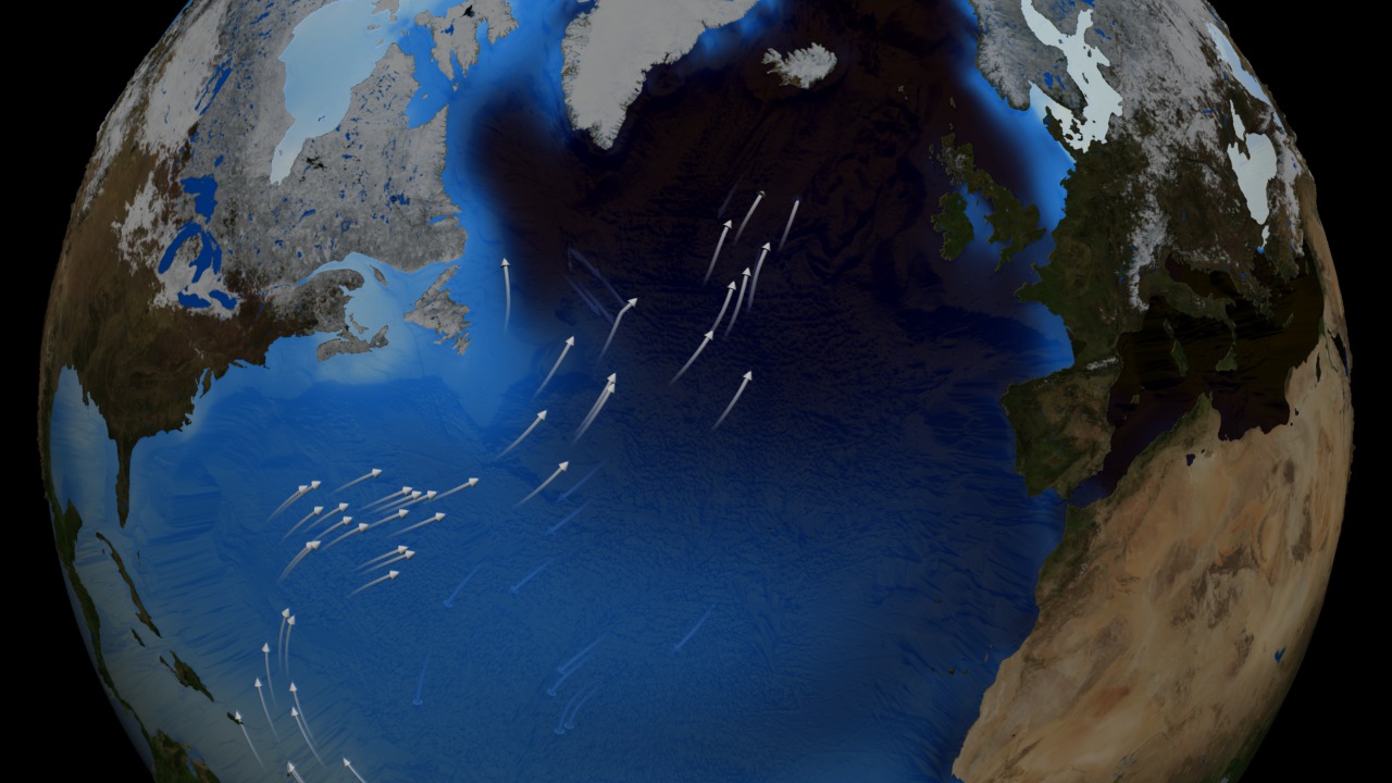
This animation shows one of the major regions where this pumping occurs, the North Atlantic Ocean around Greenland, Iceland, and the North Sea. The surface ocean current brings new water to this region from the South Atlantic via the Gulf Stream and the water returns to the South Atlantic via the North Atlantic Deep Water current. The continual influx of warm water into the North Atlantic polar ocean keeps the regions around Iceland and southern Greenland mostly free of sea ice year round.
The animation also shows another feature of the global ocean circulation: the Antarctic Circumpolar Current. The region around latitude 60 south is the the only part of the Earth where the ocean can flow all the way around the world with no land in the way. As a result, both the surface and deep waters flow from west to east around Antarctica. This circumpolar motion links the world's oceans and allows the deep water circulation from the Atlantic to rise in the Indian and Pacific Oceans and the surface circulation to close with the northward flow in the Atlantic.
The color on the world's ocean's at the beginning of this animation represents surface water density, with dark regions being most dense and light regions being least dense (see the animation Sea Surface Temperature, Salinity and Density). The depths of the oceans are highly exaggerated to better illustrate the differences between the surface flows and deep water flows. The actual flows in this model are based on current theories of the thermohaline circulation rather than actual data. The thermohaline circulation is a very slow moving current that can be difficult to distinguish from general ocean circulation. Therefore, it is difficult to measure or simulate.

Used Elsewhere In
Visualization Credits
Horace Mitchell (NASA/GSFC): Animator
Helen-Nicole Kostis (UMBC): Animator
Ryan Fitzgibbons (UMBC): Producer
Susan Lozier (Duke University): Scientist
NASA/Goddard Space Flight Center Scientific Visualization Studio The Blue Marble Next Generation data is courtesy of Reto Stockli (NASA/GSFC) and NASA's Earth Observatory.
https://svs.gsfc.nasa.gov/3658
Mission:
Terra
Data Used:
Terra and Aqua/MODIS/Blue Marble: Next Generation also referred to as: BMNG
1/1/2004 - 12/31/2004The Blue Marble data is courtesy of Reto Stockli (NASA/GSFC).
Terra/MODIS/Bathymetry
This item is part of this series:
Earth Science Week
Keywords:
SVS >> HDTV
SVS >> Ocean Floor
DLESE >> Physical oceanography
GCMD >> Earth Science >> Oceans
GCMD >> Earth Science >> Oceans >> Ocean Circulation
GCMD >> Earth Science >> Oceans >> Ocean Heat Budget
GCMD >> Earth Science >> Oceans >> Ocean Temperature
GCMD >> Earth Science >> Oceans >> Ocean Circulation >> Ocean Currents
GCMD >> Earth Science >> Oceans >> Salinity/Density >> Density
SVS >> Hyperwall
SVS >> Copenhagen
SVS >> For Educators
SVS >> Water Cycle >> Condensation
SVS >> Hydrosphere >> Ice
NASA Science >> Earth
GCMD keywords can be found on the Internet with the following citation: Olsen, L.M., G. Major, K. Shein, J. Scialdone, S. Ritz, T. Stevens, M. Morahan, A. Aleman, R. Vogel, S. Leicester, H. Weir, M. Meaux, S. Grebas, C.Solomon, M. Holland, T. Northcutt, R. A. Restrepo, R. Bilodeau, 2013. NASA/Global Change Master Directory (GCMD) Earth Science Keywords. Version 8.0.0.0.0


