Earth
ID: 3651
The Global Inventory Monitoring and Modeling Studies (GIMMS) group at NASA Goddard Space Flight Center (NASA/GSFC) provides United States Department of Agriculture/Foreign Agricultural Service (USDA/FAS) with global data stream of NDVI that spans over two decades (1981-present). The GIMMS NDVI is derived from measurements made by the Advanced Very High Resolution Radiometer (AVHRR), Global Area Coverage (GAC) data from the National Atmospheric Oceanic Administration (NOAA) polar orbiting series of satellites. GIMMS has inter-calibrated the data from the NOAA-AVHRR satellite series and performed atmospheric correction to minimize the effects of volcanic aerosols to produce and maintain a consistent NDVI archive. The NDVI archive from GIMMS provides the historic database for monitoring the response of vegetation to climatic conditions.
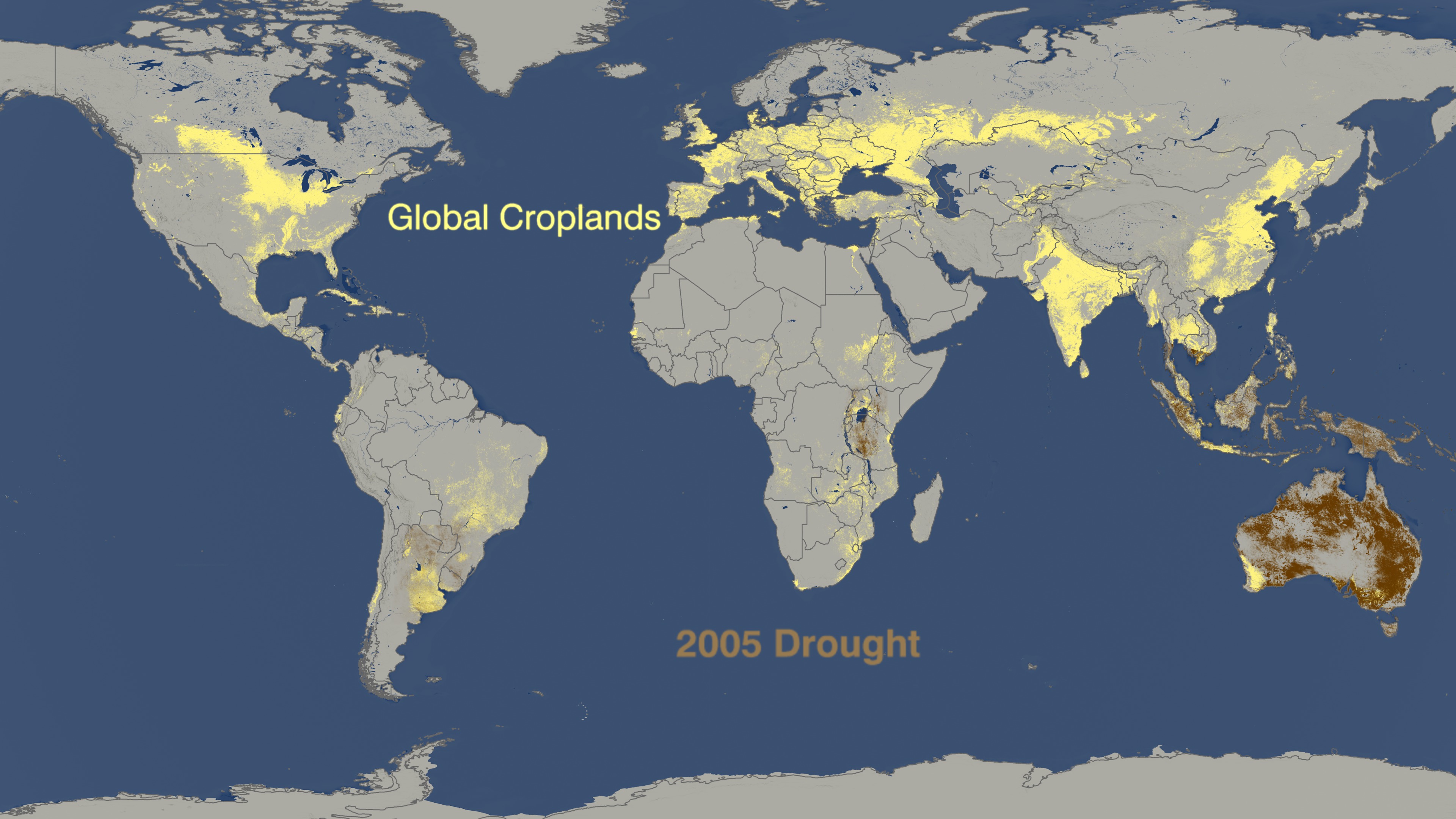
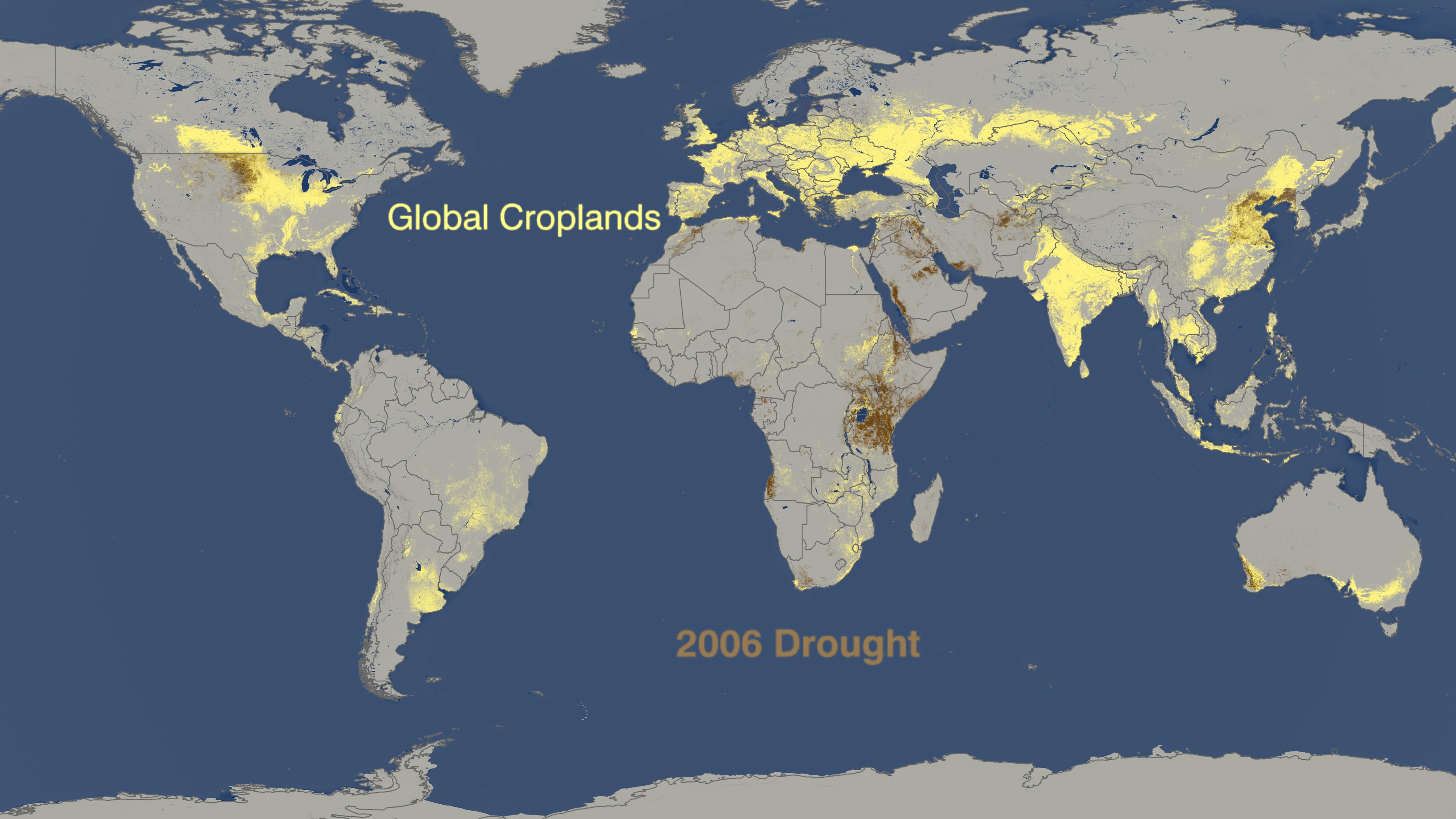


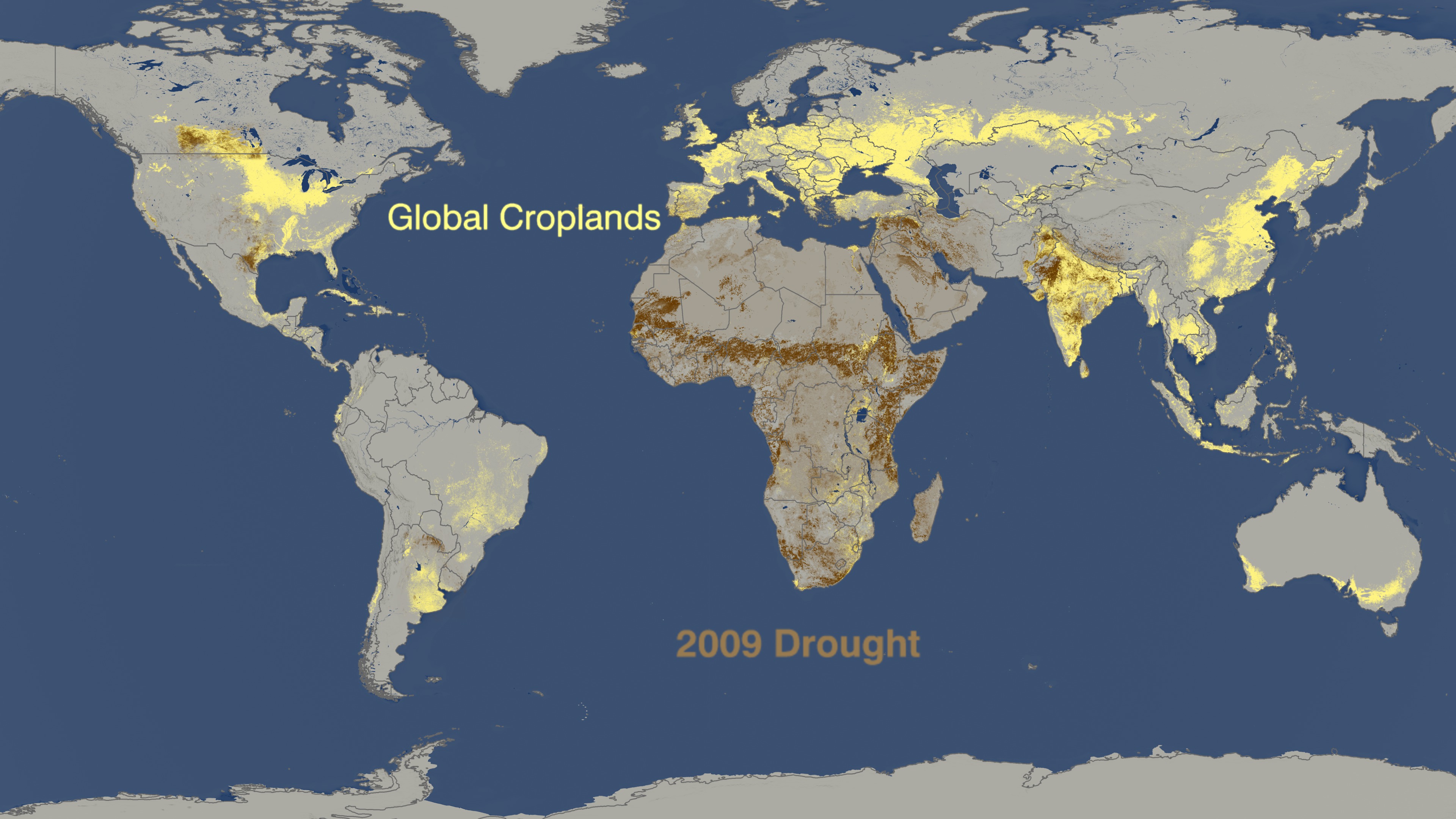
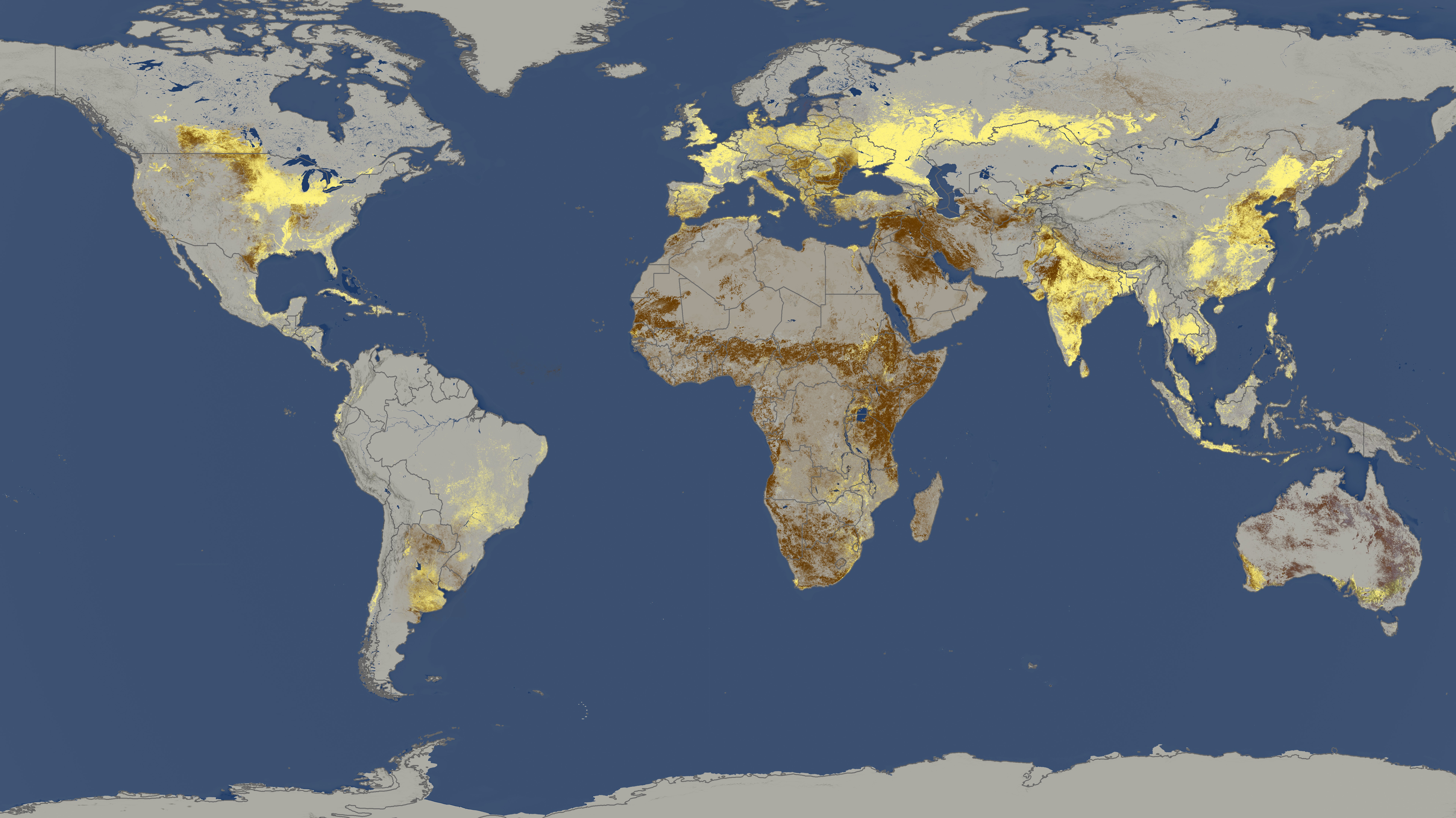
World Droughts From 2005 to 2009 Versus Where Crops are Grown
Linking the MODIS data to the long-term GIMMS AVHRR/NDVI, archive and SPOT Vegetation sensor data is a critical component of this project providing a consistent multi-source long-term data record for agricultural monitoring. This allows FAS analysts to compare current data with the spatial extent and severity of NDVI anomalies associated with heat stress, droughts and floods associated with crop failures.
Related Documentation
Visualization Credits
Lori Perkins (NASA/GSFC): Lead Animator
Michelle Williams (UMBC): Producer
Chris Justice (University of Maryland): Scientist
Inbal Becker Reshef (University of Maryland): Scientist
Jesse Allen (Sigma Space Corporation): Project Support
Michelle Williams (UMBC): Producer
Chris Justice (University of Maryland): Scientist
Inbal Becker Reshef (University of Maryland): Scientist
Jesse Allen (Sigma Space Corporation): Project Support
Please give credit for this item to:
NASA/Goddard Space Flight Center
NASA/Goddard Space Flight Center
Short URL to share this page:
https://svs.gsfc.nasa.gov/3651
Mission:
Terra
Data Used:
Note: While we identify the data sets used in these visualizations, we do not store any further details nor the data sets themselves on our site.
This item is part of these series:
NASA and Agriculture - Animations
Agriculture Animations - Global Agricultural Monitoring
Keywords:
DLESE >> Atmospheric science
SVS >> HDTV
DLESE >> Natural hazards
GCMD >> Earth Science >> Agriculture
GCMD >> Earth Science >> Climate Indicators >> Drought Indices
GCMD >> Earth Science >> Atmosphere >> Atmospheric Phenomena >> Drought
GCMD >> Earth Science >> Human Dimensions >> Natural Hazards >> Fires
SVS >> Hyperwall
SVS >> For Educators
SVS >> Depletion of Food
SVS >> Farming
NASA Science >> Earth
GCMD >> Earth Science >> Human Dimensions >> Natural Hazards >> Famine
GCMD keywords can be found on the Internet with the following citation: Olsen, L.M., G. Major, K. Shein, J. Scialdone, S. Ritz, T. Stevens, M. Morahan, A. Aleman, R. Vogel, S. Leicester, H. Weir, M. Meaux, S. Grebas, C.Solomon, M. Holland, T. Northcutt, R. A. Restrepo, R. Bilodeau, 2013. NASA/Global Change Master Directory (GCMD) Earth Science Keywords. Version 8.0.0.0.0
https://svs.gsfc.nasa.gov/3651
Mission:
Terra
Data Used:
Terra and Aqua/MODIS/Normalized Difference Vegetation Index (NDVI) also referred to as: NDVI
NASA - 2005 through 2009Terra and Aqua/MODIS/Composite Vegetation Index also referred to as: VI
Data Compilation - NASA - 2005 through 2009This item is part of these series:
NASA and Agriculture - Animations
Agriculture Animations - Global Agricultural Monitoring
Keywords:
DLESE >> Atmospheric science
SVS >> HDTV
DLESE >> Natural hazards
GCMD >> Earth Science >> Agriculture
GCMD >> Earth Science >> Climate Indicators >> Drought Indices
GCMD >> Earth Science >> Atmosphere >> Atmospheric Phenomena >> Drought
GCMD >> Earth Science >> Human Dimensions >> Natural Hazards >> Fires
SVS >> Hyperwall
SVS >> For Educators
SVS >> Depletion of Food
SVS >> Farming
NASA Science >> Earth
GCMD >> Earth Science >> Human Dimensions >> Natural Hazards >> Famine
GCMD keywords can be found on the Internet with the following citation: Olsen, L.M., G. Major, K. Shein, J. Scialdone, S. Ritz, T. Stevens, M. Morahan, A. Aleman, R. Vogel, S. Leicester, H. Weir, M. Meaux, S. Grebas, C.Solomon, M. Holland, T. Northcutt, R. A. Restrepo, R. Bilodeau, 2013. NASA/Global Change Master Directory (GCMD) Earth Science Keywords. Version 8.0.0.0.0


