Earth
ID: 3597
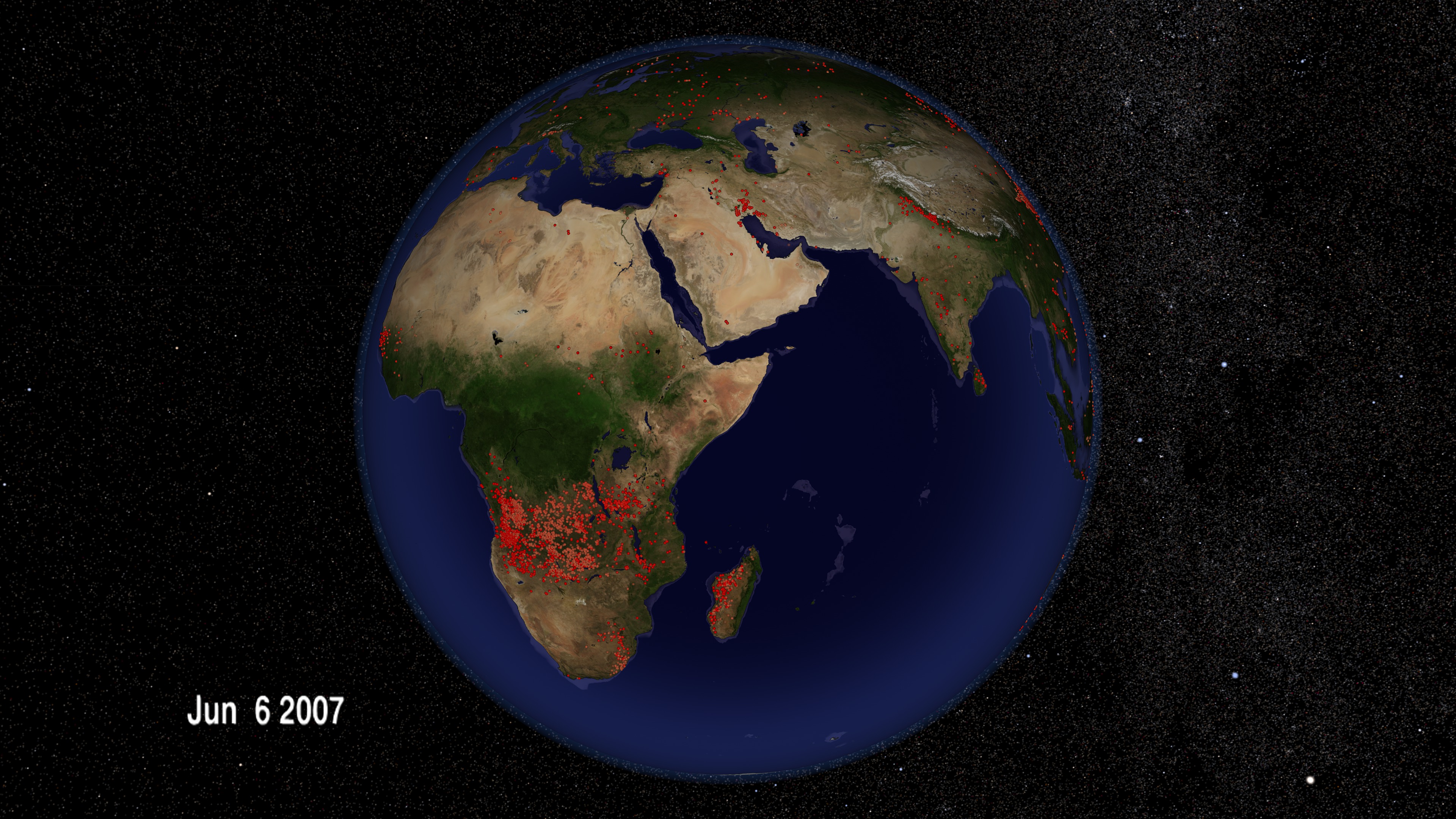
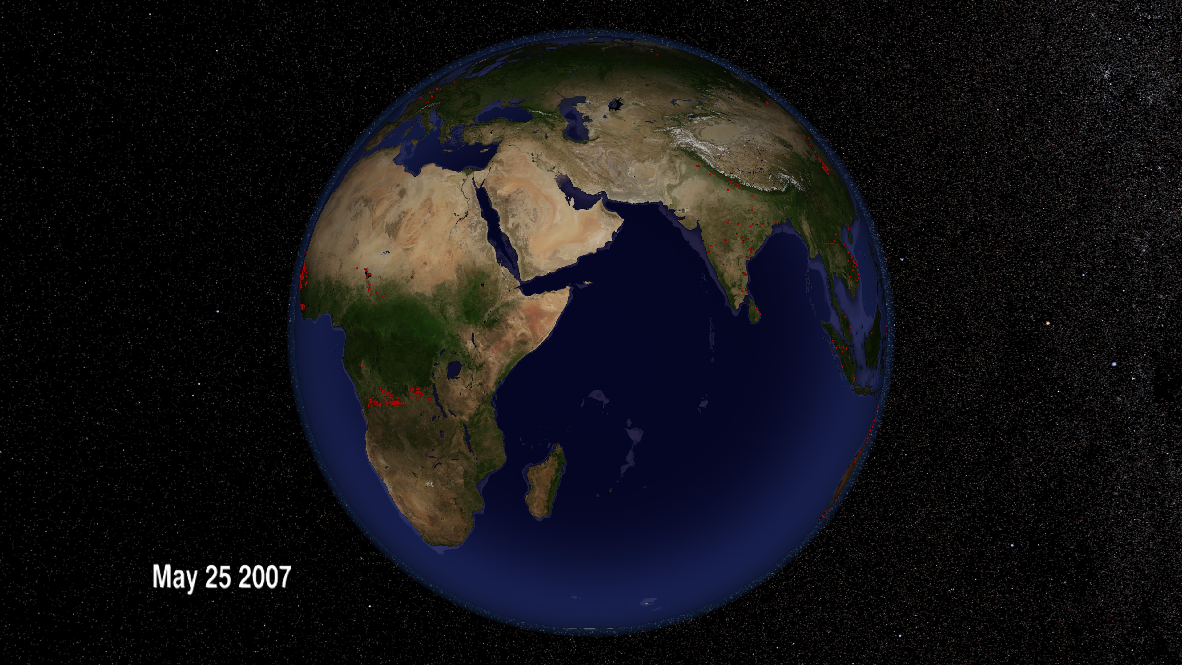
From space, we can understand fires in ways that are impossible from the ground. NASA research has contributed to much improved detection of fire for scientific purposes using satellite remote sensing and geographic information systems. This has helped advance our understanding of the impacts of fire in many areas of earth science, including atmospheric chemistry and the impacts on protected areas. This research has led to the development of a rapid response system widely used throughout the world for both natural resource management and for firefighting by providing near real-time information. In this animation of fires around the globe in 2007, each red dot marks a new fire. From brush fires in Africa to forest fires in North America, satellites are locating every significant fire on Earth to within one kilometer. More information on the Fire Information for Resource Management (FIRMS) is available at http://maps.geog.umd.edu/firms/
Fire Observations - As the World Turns
Visualization Credits
Lori Perkins (NASA/GSFC): Lead Animator
Greg Shirah (NASA/GSFC): Animator
Michelle Williams (UMBC): Producer
Chris Justice (University of Maryland): Scientist
Louis Giglio (SSAI): Scientist
Inbal Becker Reshef (University of Maryland): Scientist
Greg Shirah (NASA/GSFC): Animator
Michelle Williams (UMBC): Producer
Chris Justice (University of Maryland): Scientist
Louis Giglio (SSAI): Scientist
Inbal Becker Reshef (University of Maryland): Scientist
Please give credit for this item to:
NASA/Goddard Space Flight Center Scientific Visualization Studio
NASA/Goddard Space Flight Center Scientific Visualization Studio
Short URL to share this page:
https://svs.gsfc.nasa.gov/3597
Missions:
Landsat
QuikSCAT
Shuttle Radar Topography Mission - SRTM
Terra
Tropical Rainfall Measuring Mission - TRMM
Data Used:
Note: While we identify the data sets used in these visualizations, we do not store any further details nor the data sets themselves on our site.
Dates of Data Used:
2001/10/01 - 2002/09/30
This item is part of these series:
Fires
Multisensor Fire Observations
Agriculture Animations - Fires
Goddard TV Tape:
G2008-042HD -- HD Fires, Ozone, and Air Quality RT
Keywords:
DLESE >> Atmospheric science
SVS >> Biscuit
DLESE >> Forestry
SVS >> HDTV
SVS >> Hayman
DLESE >> Natural hazards
SVS >> Rodeo
GCMD >> Earth Science >> Biosphere >> Ecological Dynamics >> Fire Occurrence
GCMD >> Earth Science >> Human Dimensions >> Natural Hazards >> Fires
SVS >> GOES
SVS >> For Educators
SVS >> Ecosystems
SVS >> Natural Disaster
NASA Science >> Earth
GCMD keywords can be found on the Internet with the following citation: Olsen, L.M., G. Major, K. Shein, J. Scialdone, S. Ritz, T. Stevens, M. Morahan, A. Aleman, R. Vogel, S. Leicester, H. Weir, M. Meaux, S. Grebas, C.Solomon, M. Holland, T. Northcutt, R. A. Restrepo, R. Bilodeau, 2013. NASA/Global Change Master Directory (GCMD) Earth Science Keywords. Version 8.0.0.0.0
https://svs.gsfc.nasa.gov/3597
Missions:
Landsat
QuikSCAT
Shuttle Radar Topography Mission - SRTM
Terra
Tropical Rainfall Measuring Mission - TRMM
Data Used:
Terra/MISR
SRTM/SIR-C
Gridded Population of the World (Version 3 Beta)
Data Compilation - SEDACEarth Probe/TOMS/Aerosol Index
10-meter DEM
USGSTerra/MODIS/NDVI
QuikSCAT/SeaWinds/Wind
GTOPO30
Model - USGSTerra and Aqua/MODIS/Fire Location
Jan 1, 2007 through Dec 31, 2007
Credit:
Fire location data courtesy of MODIS Rapid Response Project (NASA/GSFC and University of Maryland - http://rapidfire.sci.gsfc.nasa.gov)
Fire location data courtesy of MODIS Rapid Response Project (NASA/GSFC and University of Maryland - http://rapidfire.sci.gsfc.nasa.gov)
Dates of Data Used:
2001/10/01 - 2002/09/30
This item is part of these series:
Fires
Multisensor Fire Observations
Agriculture Animations - Fires
Goddard TV Tape:
G2008-042HD -- HD Fires, Ozone, and Air Quality RT
Keywords:
DLESE >> Atmospheric science
SVS >> Biscuit
DLESE >> Forestry
SVS >> HDTV
SVS >> Hayman
DLESE >> Natural hazards
SVS >> Rodeo
GCMD >> Earth Science >> Biosphere >> Ecological Dynamics >> Fire Occurrence
GCMD >> Earth Science >> Human Dimensions >> Natural Hazards >> Fires
SVS >> GOES
SVS >> For Educators
SVS >> Ecosystems
SVS >> Natural Disaster
NASA Science >> Earth
GCMD keywords can be found on the Internet with the following citation: Olsen, L.M., G. Major, K. Shein, J. Scialdone, S. Ritz, T. Stevens, M. Morahan, A. Aleman, R. Vogel, S. Leicester, H. Weir, M. Meaux, S. Grebas, C.Solomon, M. Holland, T. Northcutt, R. A. Restrepo, R. Bilodeau, 2013. NASA/Global Change Master Directory (GCMD) Earth Science Keywords. Version 8.0.0.0.0


