Earth
ID: 3511
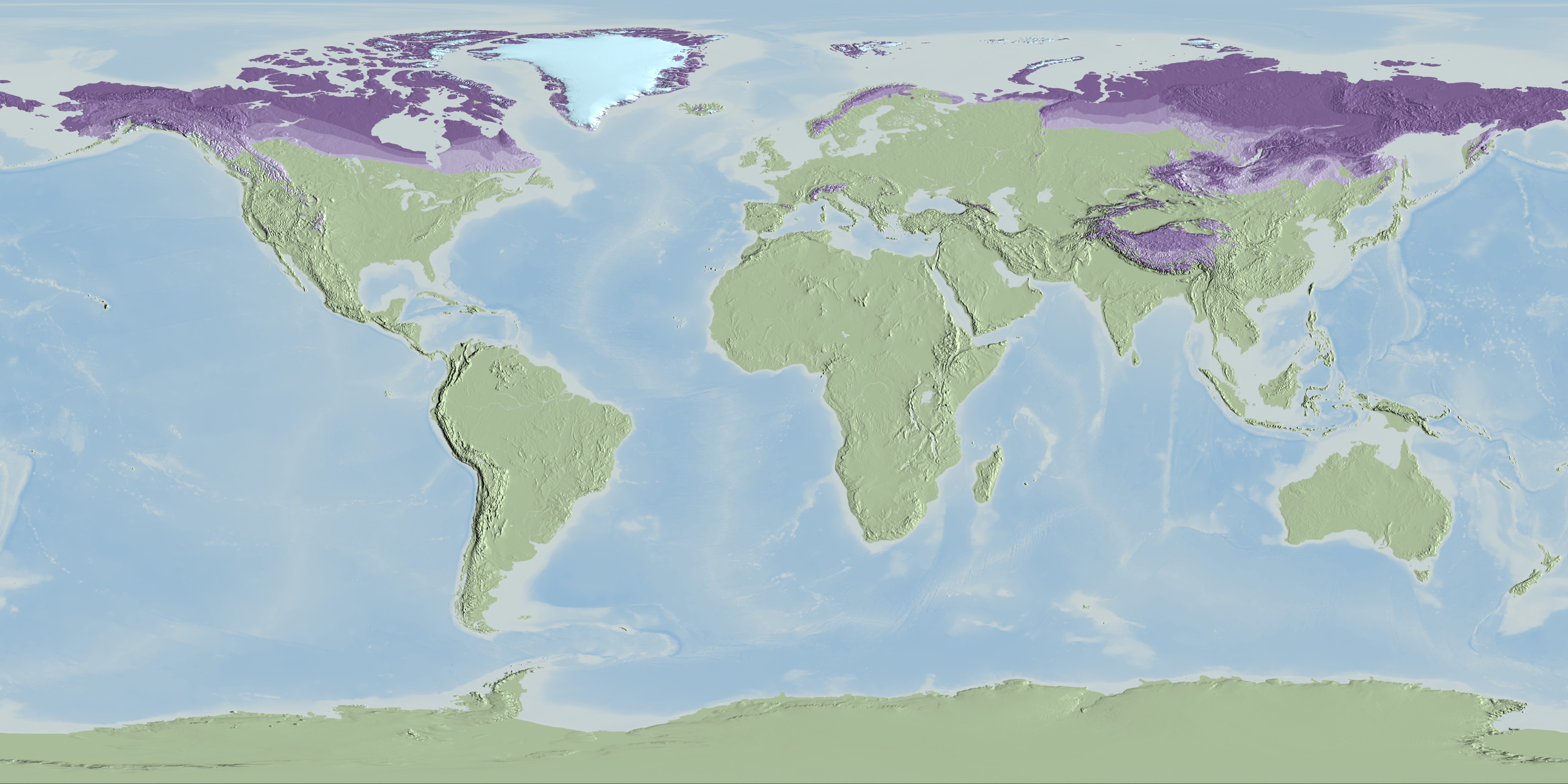
Permafrost is permanently frozen ground that remains at or below 0°C for at least two years. The circumpolar permafrost and ground ice data depicts the distribution of permafrost and ground ice in the Northern Hemisphere and shows continuous, discontinuous, sporadic, and isolated permafrost boundaries.


Global Permafrost Layers designed for Science On a Sphere (SOS) and WMS
Visualization Credits
Cindy Starr (Global Science and Technology, Inc.): Lead Visualizer
Victoria Weeks (HTSI): Video Editor
Michael Starobin (HTSI): Producer
Victoria Weeks (HTSI): Video Editor
Michael Starobin (HTSI): Producer
Please give credit for this item to:
NASA/Goddard Space Flight Center Scientific Visualization Studio
National Snow and Ice Data Center
World Data Center for Glaciology
NASA/Goddard Space Flight Center Scientific Visualization Studio
National Snow and Ice Data Center
World Data Center for Glaciology
Short URL to share this page:
https://svs.gsfc.nasa.gov/3511
Data Used:
Note: While we identify the data sets used in these visualizations, we do not store any further details nor the data sets themselves on our site.
This item is part of these series:
SOS Production - FROZEN
Science On a Sphere
Keywords:
DLESE >> Cryology
GCMD >> Earth Science >> Cryosphere
GCMD >> Earth Science >> Atmosphere >> Precipitation >> Snow
GCMD >> Earth Science >> Cryosphere >> Frozen Ground >> Permafrost
SVS >> For Educators
SVS >> Hydrosphere >> Ice
NASA Science >> Earth
GCMD keywords can be found on the Internet with the following citation: Olsen, L.M., G. Major, K. Shein, J. Scialdone, S. Ritz, T. Stevens, M. Morahan, A. Aleman, R. Vogel, S. Leicester, H. Weir, M. Meaux, S. Grebas, C.Solomon, M. Holland, T. Northcutt, R. A. Restrepo, R. Bilodeau, 2013. NASA/Global Change Master Directory (GCMD) Earth Science Keywords. Version 8.0.0.0.0
https://svs.gsfc.nasa.gov/3511
Data Used:
Circum-Arctic Map of Permafrost and Ground-Ice Conditions
Data Compilation - NSIDCThis item is part of these series:
SOS Production - FROZEN
Science On a Sphere
Keywords:
DLESE >> Cryology
GCMD >> Earth Science >> Cryosphere
GCMD >> Earth Science >> Atmosphere >> Precipitation >> Snow
GCMD >> Earth Science >> Cryosphere >> Frozen Ground >> Permafrost
SVS >> For Educators
SVS >> Hydrosphere >> Ice
NASA Science >> Earth
GCMD keywords can be found on the Internet with the following citation: Olsen, L.M., G. Major, K. Shein, J. Scialdone, S. Ritz, T. Stevens, M. Morahan, A. Aleman, R. Vogel, S. Leicester, H. Weir, M. Meaux, S. Grebas, C.Solomon, M. Holland, T. Northcutt, R. A. Restrepo, R. Bilodeau, 2013. NASA/Global Change Master Directory (GCMD) Earth Science Keywords. Version 8.0.0.0.0


