Earth
ID: 3437
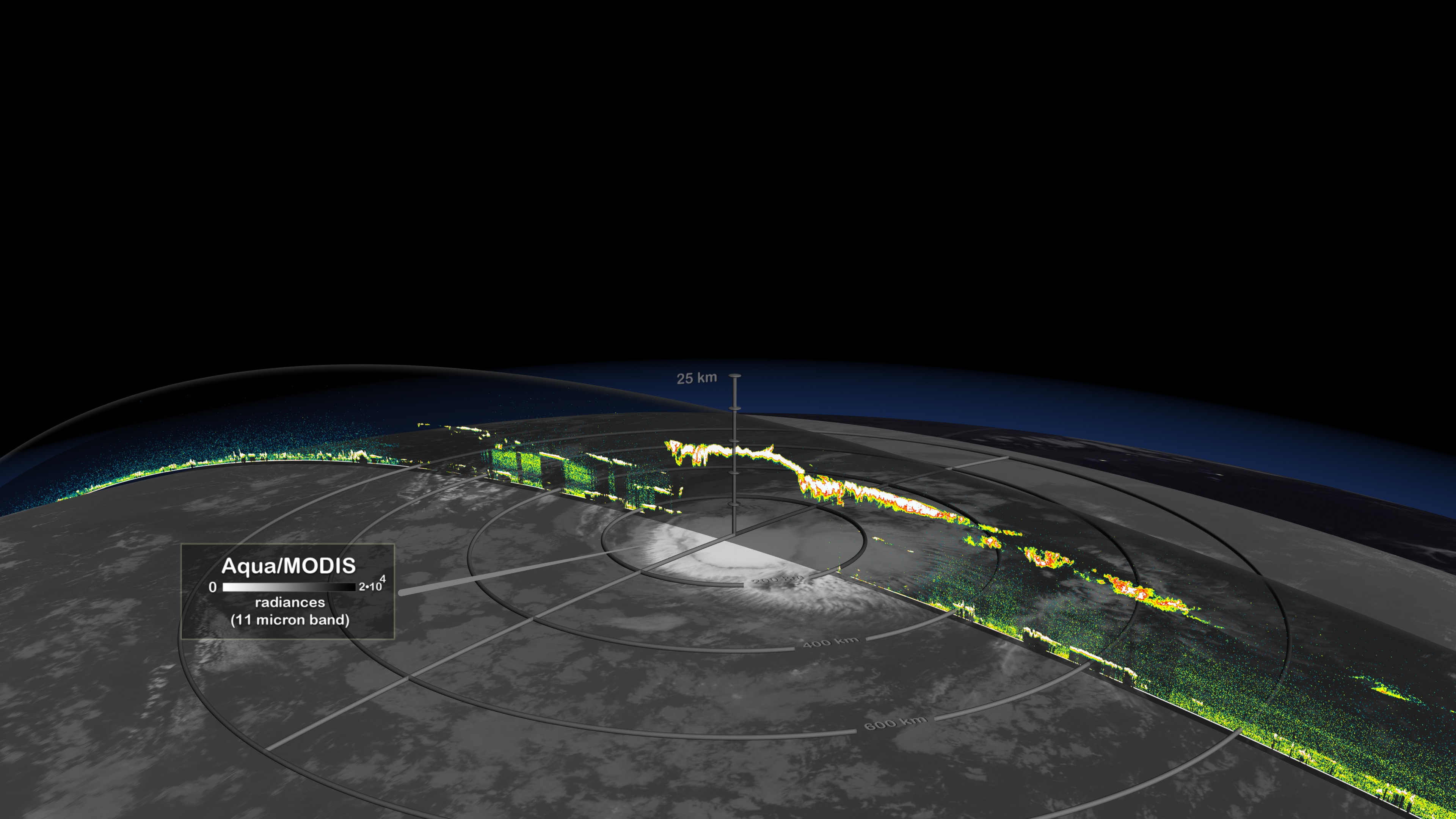
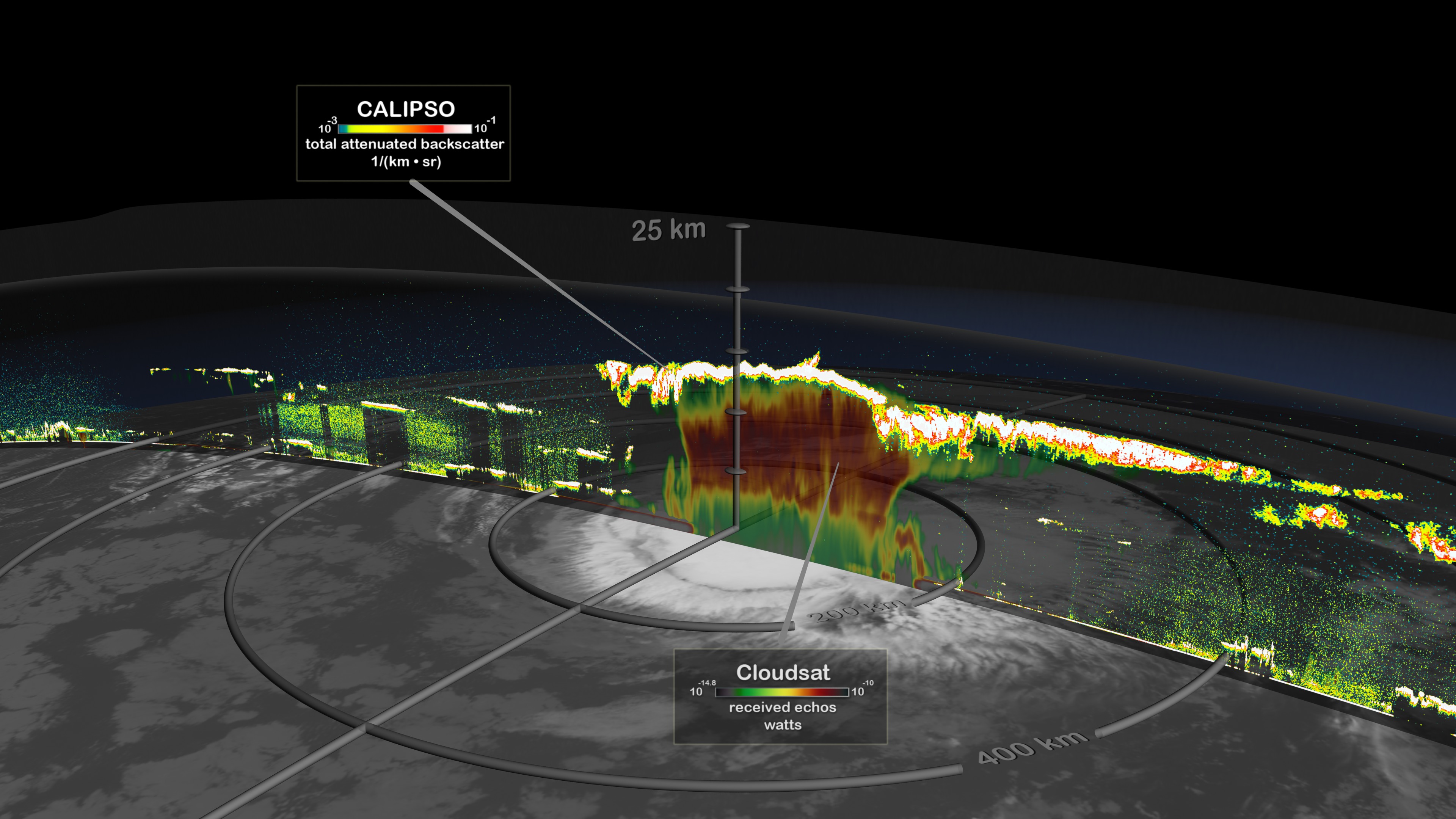
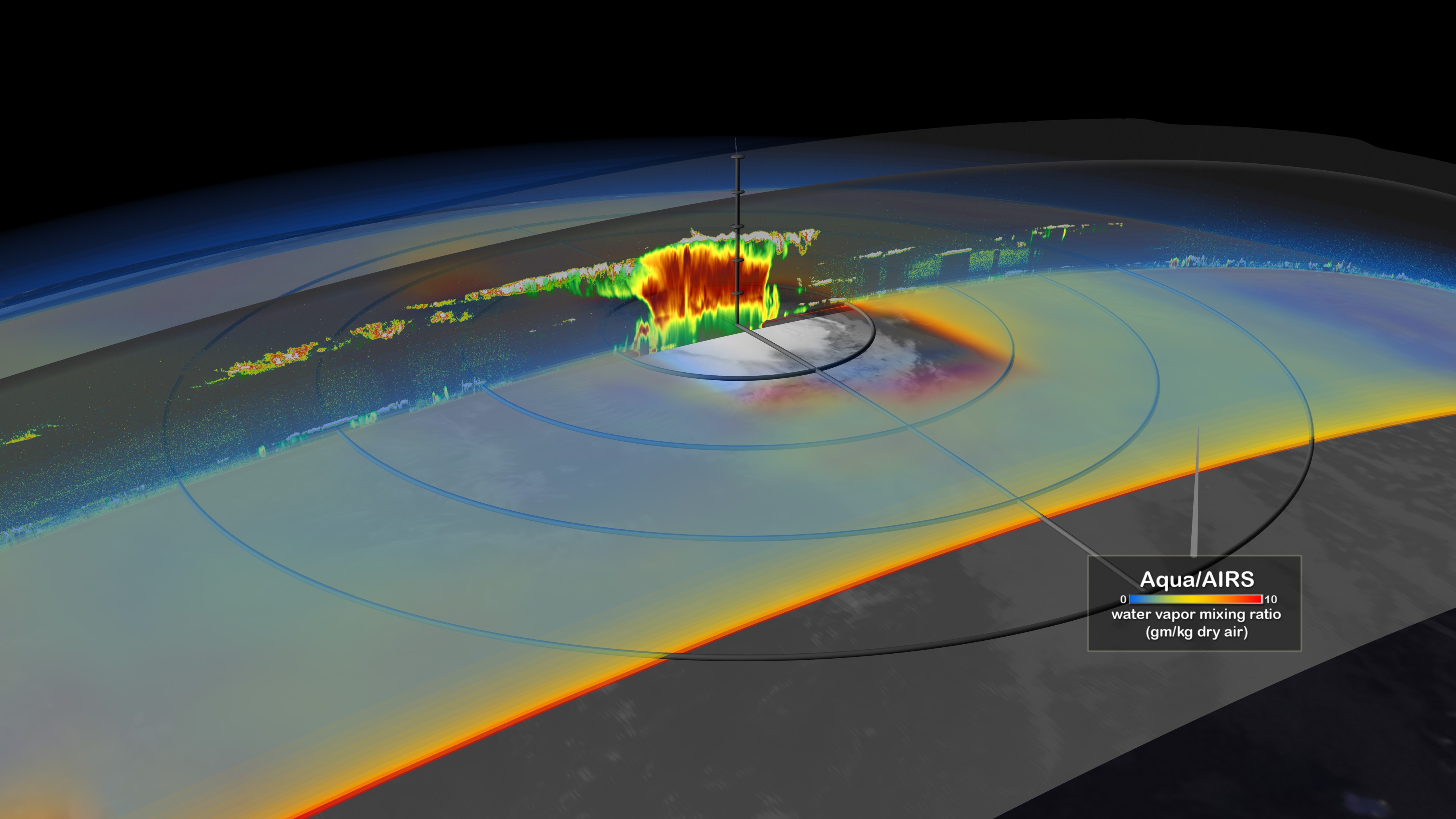
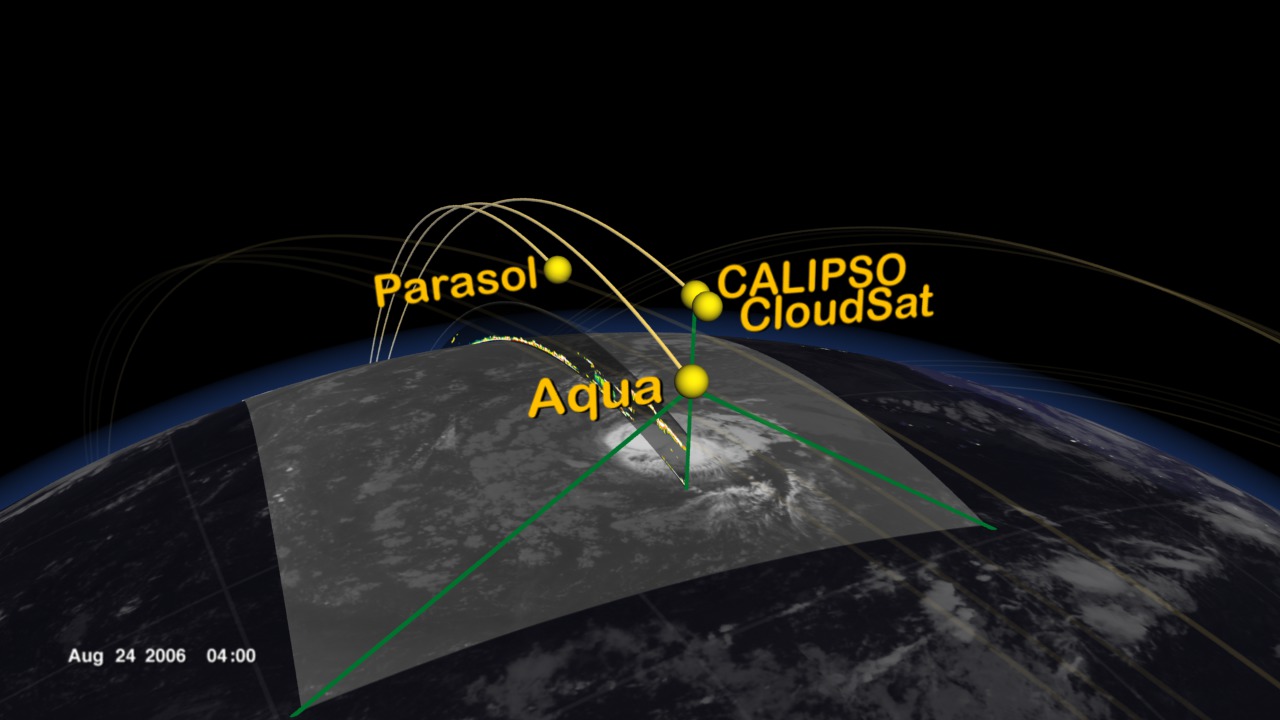
The A-Train is a group of spacecraft flying in close formation allowing data taken by each instrument to be correlated to the other instruments providing data synergy. The A-Train includes Aqua, CloudSat, CALIPSO, Parasol, and Aura. The animation begins showing the Earth with moving clouds and with a day/night terminator. Time slows down, and A-train spacecraft orbits are added during a daytime pass. The orbits progress around the globe for 12 hours. During a night time pass the camera zooms into Tropical Storm Debby as the A-train flies over on August 24, 2006. Data sets from some of the A-train's spacecraft/instruments are shown including Aqua/MODIS, CloudSat, CALIPSO, and Aqua/AIRS. This visualization was created to support an A-Train session at the 2007 International Geoscience and Remote Sensing Symposium (IGARSS).
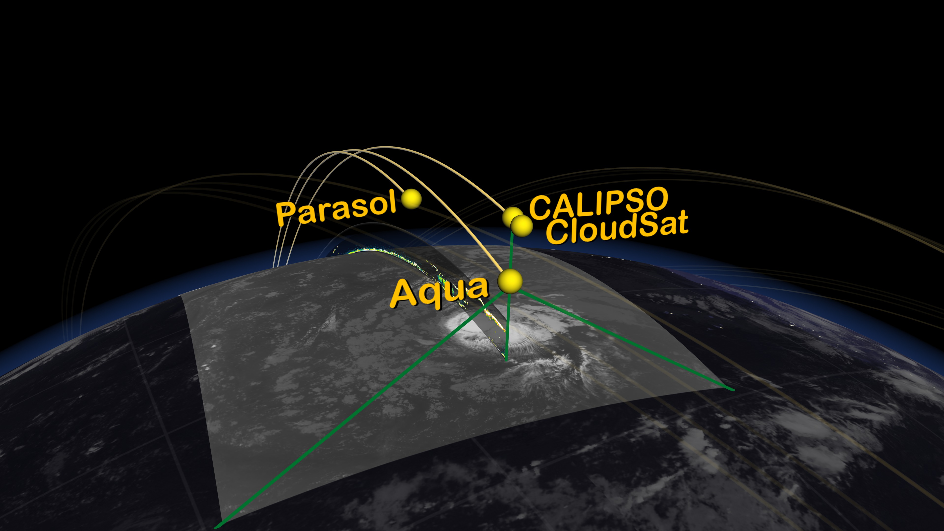
The A-Train Observes Tropical Storm Debby
Visualization Credits
Greg Shirah (NASA/GSFC): Lead Animator
Cindy Starr (Global Science and Technology, Inc.): Visualizer
Jeff de La Beaujardiere (NASA): Animator
Tom Bridgman (Global Science and Technology, Inc.): Animator
Charles Trepte (NASA/LaRC): Scientist
Cindy Starr (Global Science and Technology, Inc.): Visualizer
Jeff de La Beaujardiere (NASA): Animator
Tom Bridgman (Global Science and Technology, Inc.): Animator
Charles Trepte (NASA/LaRC): Scientist
Please give credit for this item to:
NASA/Goddard Space Flight Center Scientific Visualization Studio
NASA/Goddard Space Flight Center Scientific Visualization Studio
Short URL to share this page:
https://svs.gsfc.nasa.gov/3437
Missions:
CALIPSO
Cloudsat
Data Used:
Note: While we identify the data sets used in these visualizations, we do not store any further details nor the data sets themselves on our site.
Keywords:
DLESE >> Atmospheric science
SVS >> HDTV
GCMD >> Earth Science >> Atmosphere >> Clouds >> Cloud Liquid Water/Ice
SVS >> Hyperwall
SVS >> iPod
NASA Science >> Earth
GCMD keywords can be found on the Internet with the following citation: Olsen, L.M., G. Major, K. Shein, J. Scialdone, S. Ritz, T. Stevens, M. Morahan, A. Aleman, R. Vogel, S. Leicester, H. Weir, M. Meaux, S. Grebas, C.Solomon, M. Holland, T. Northcutt, R. A. Restrepo, R. Bilodeau, 2013. NASA/Global Change Master Directory (GCMD) Earth Science Keywords. Version 8.0.0.0.0
https://svs.gsfc.nasa.gov/3437
Missions:
CALIPSO
Cloudsat
Data Used:
Aqua/AIRS
08/24/2006
For more information on the Atmospheric Infrared Sounder, click http://www-airs.jpl.nasa.gov/
Aqua/MODIS
08/24/2006CALIPSO/CALIOP
08/24/2006
Cloud-Aerosol Lidar with Orthogonal Polarization
CloudSat/CPR
08/24/2006DMSP/OLS/Earth at Night
TOPEX/Poseidon/Sea Surface Height Anomaly
CPC (Climate Prediction Center) Cloud Composite
Data Compilation - Climate Prediction Center (CPC) - 08/14/2006 - 08/24/2006
Global cloud cover from multiple satellites
Keywords:
DLESE >> Atmospheric science
SVS >> HDTV
GCMD >> Earth Science >> Atmosphere >> Clouds >> Cloud Liquid Water/Ice
SVS >> Hyperwall
SVS >> iPod
NASA Science >> Earth
GCMD keywords can be found on the Internet with the following citation: Olsen, L.M., G. Major, K. Shein, J. Scialdone, S. Ritz, T. Stevens, M. Morahan, A. Aleman, R. Vogel, S. Leicester, H. Weir, M. Meaux, S. Grebas, C.Solomon, M. Holland, T. Northcutt, R. A. Restrepo, R. Bilodeau, 2013. NASA/Global Change Master Directory (GCMD) Earth Science Keywords. Version 8.0.0.0.0


