Earth
ID: 3436
Associated with tropical thunderstorms are broad fields of cirrus clouds that flow out of the tops of the vigorous storm systems that form over warm tropical oceans. These clouds play a role in how much infrared energy is trapped in Earth's atmosphere. NASA's Tropical Composition, Cloud and Climate Coupling (TC4) mission, which runs from July 16, 2007 through August 8, 2007, aims to document the full lifecycle of these clouds. Observations from four A-Train satellites flying in formation will complement the aircraft measurements with large-scale views of many different features of the atmosphere. Observations from this mission along with previous studies will improve our understanding of what effect a warming climate with rising ocean temperatures will have on these cloud systems. These images over Central America, produced in support of the TC4 mission, show a tropical storm system over Central and South America on August 2, 2006 as measured from multiple satellite sensors, including Aqua MODIS, CloudSat and CALIPSO. In this view from the Pacific Ocean, Panama is on the left and South America is shown on the right. In the following series of still images, each satellite's measurement is shown individually and in combination with the others from the same camera viewpoint. The profile showing CloudSat and CALIPSO data is truncated at a height of twenty kilometers and exaggerated ten times. The land topography is also exaggerated by a factor of ten.
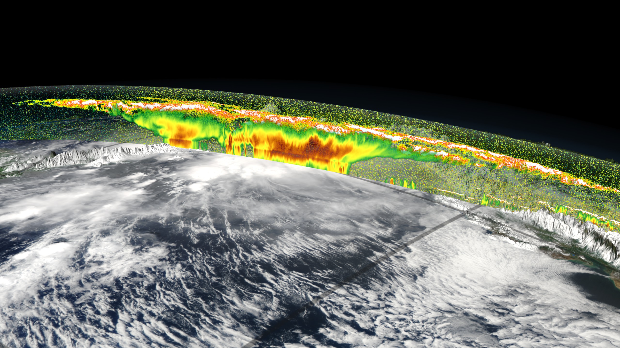


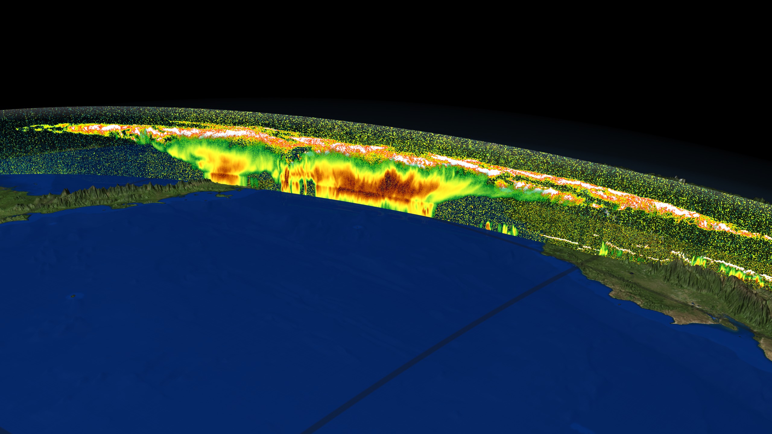


CloudSat, Calipso and MODIS over Central America
Visualization Credits
Cindy Starr (Global Science and Technology, Inc.): Lead Visualizer
Lori Perkins (NASA/GSFC): Animator
Brian Toon (University of Colorado): Scientist
Lori Perkins (NASA/GSFC): Animator
Brian Toon (University of Colorado): Scientist
Please give credit for this item to:
NASA/Goddard Space Flight Center Scientific Visualization Studio The Next Generation Blue Marble data is courtesy of Reto Stockli (NASA/GSFC). MODIS data data courtesy of Jeff Schmaltz, MODIS Rapid Response Project (NASA/GSFC)
NASA/Goddard Space Flight Center Scientific Visualization Studio The Next Generation Blue Marble data is courtesy of Reto Stockli (NASA/GSFC). MODIS data data courtesy of Jeff Schmaltz, MODIS Rapid Response Project (NASA/GSFC)
Short URL to share this page:
https://svs.gsfc.nasa.gov/3436
Missions:
CALIPSO
Cloudsat
Terra
Tropical Rainfall Measuring Mission - TRMM
Data Used:
Note: While we identify the data sets used in these visualizations, we do not store any further details nor the data sets themselves on our site.
Keywords:
DLESE >> Atmospheric science
GCMD >> Earth Science >> Atmosphere
GCMD >> Earth Science >> Atmosphere >> Atmospheric Phenomena
GCMD >> Earth Science >> Atmosphere >> Clouds
GCMD >> Earth Science >> Atmosphere >> Atmospheric Water Vapor >> Precipitable Water
GCMD >> Earth Science >> Atmosphere >> Clouds >> Cloud Height
GCMD >> Earth Science >> Atmosphere >> Clouds >> Cloud Liquid Water/Ice
GCMD >> Earth Science >> Atmosphere >> Clouds >> Cloud Optical Depth/Thickness
GCMD >> Earth Science >> Atmosphere >> Clouds >> Cloud Precipitable Water
GCMD >> Earth Science >> Atmosphere >> Clouds >> Cloud Reflectance
GCMD >> Earth Science >> Atmosphere >> Clouds >> Cloud Types
NASA Science >> Earth
GCMD keywords can be found on the Internet with the following citation: Olsen, L.M., G. Major, K. Shein, J. Scialdone, S. Ritz, T. Stevens, M. Morahan, A. Aleman, R. Vogel, S. Leicester, H. Weir, M. Meaux, S. Grebas, C.Solomon, M. Holland, T. Northcutt, R. A. Restrepo, R. Bilodeau, 2013. NASA/Global Change Master Directory (GCMD) Earth Science Keywords. Version 8.0.0.0.0
https://svs.gsfc.nasa.gov/3436
Missions:
CALIPSO
Cloudsat
Terra
Tropical Rainfall Measuring Mission - TRMM
Data Used:
Aqua/MODIS
2006-08-02TRMM/PR and TMI/Monthly Average Precipitation
2006-08-02Terra/MODIS/Land Surface Reflectance
NASA - 2006-08-02CALIPSO/CALIOP/Total Attenuated Backscatter
2006-08-02CloudSat/CPR/Received Echo Powers
NASA/JPL and the Canadian Space Agency (CSA) - 2006-08-02
CloudSat data Level1 B CPR (Cloud Profiling Radar)
Keywords:
DLESE >> Atmospheric science
GCMD >> Earth Science >> Atmosphere
GCMD >> Earth Science >> Atmosphere >> Atmospheric Phenomena
GCMD >> Earth Science >> Atmosphere >> Clouds
GCMD >> Earth Science >> Atmosphere >> Atmospheric Water Vapor >> Precipitable Water
GCMD >> Earth Science >> Atmosphere >> Clouds >> Cloud Height
GCMD >> Earth Science >> Atmosphere >> Clouds >> Cloud Liquid Water/Ice
GCMD >> Earth Science >> Atmosphere >> Clouds >> Cloud Optical Depth/Thickness
GCMD >> Earth Science >> Atmosphere >> Clouds >> Cloud Precipitable Water
GCMD >> Earth Science >> Atmosphere >> Clouds >> Cloud Reflectance
GCMD >> Earth Science >> Atmosphere >> Clouds >> Cloud Types
NASA Science >> Earth
GCMD keywords can be found on the Internet with the following citation: Olsen, L.M., G. Major, K. Shein, J. Scialdone, S. Ritz, T. Stevens, M. Morahan, A. Aleman, R. Vogel, S. Leicester, H. Weir, M. Meaux, S. Grebas, C.Solomon, M. Holland, T. Northcutt, R. A. Restrepo, R. Bilodeau, 2013. NASA/Global Change Master Directory (GCMD) Earth Science Keywords. Version 8.0.0.0.0


