Earth
ID: 3294
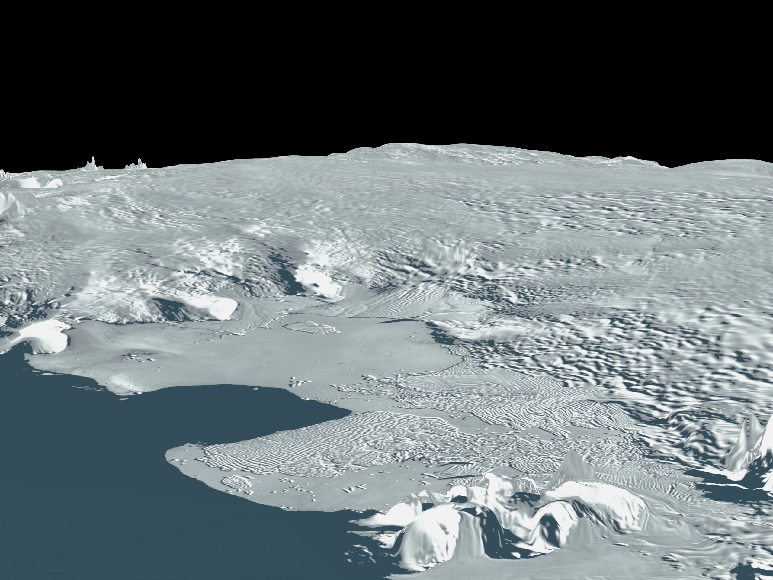
NASA has released a digital image map of the Antarctic continent and surrounding islands. The Moderate Resolution Imaging Spectroradiometer (MODIS) Mosaic of Antarctica (MOA) image map is a composite of 260 swaths comprised of both Terra and Aqua MODIS images acquired between November 20, 2003 and February 29, 2004. MOA provides a cloud-free view of the ice sheet, ice shelves, and land surfaces at a grid scale of 125 m and an estimated resolution of 150 m. All land areas south of 60° S that are larger than a few hundred meters are included in the mosaic. Also included are several persistent fast ice areas and grounded icebergs.
MODIS Mosaic of Antarctica view of Pine Island and Thwaites Glacier
Related

Visualization Credits
Please give credit for this item to:
Haran, T., J. Bohlander, T. Scambos, and M. Fahnestock compilers. 2005. MODIS mosaic of Antarctica (MOA) image map. Boulder, CO, USA: National Snow and Ice Data Center. Digital media. NASA/Goddard Space Flight Center Scientific Visualization Studio
Haran, T., J. Bohlander, T. Scambos, and M. Fahnestock compilers. 2005. MODIS mosaic of Antarctica (MOA) image map. Boulder, CO, USA: National Snow and Ice Data Center. Digital media. NASA/Goddard Space Flight Center Scientific Visualization Studio
Short URL to share this page:
https://svs.gsfc.nasa.gov/3294
Missions:
Ice, Cloud, and land Elevation Satellite (ICESat)
Terra
Data Used:
Note: While we identify the data sets used in these visualizations, we do not store any further details nor the data sets themselves on our site.
This item is part of this series:
MODIS Mosaic of Antarctica (MOA)
Keywords:
GCMD >> Earth Science >> Cryosphere >> Glaciers/Ice Sheets
NASA Science >> Earth
GCMD keywords can be found on the Internet with the following citation: Olsen, L.M., G. Major, K. Shein, J. Scialdone, S. Ritz, T. Stevens, M. Morahan, A. Aleman, R. Vogel, S. Leicester, H. Weir, M. Meaux, S. Grebas, C.Solomon, M. Holland, T. Northcutt, R. A. Restrepo, R. Bilodeau, 2013. NASA/Global Change Master Directory (GCMD) Earth Science Keywords. Version 8.0.0.0.0
https://svs.gsfc.nasa.gov/3294
Missions:
Ice, Cloud, and land Elevation Satellite (ICESat)
Terra
Data Used:
ICESat/GLAS/L1B Global Elevation Data (GLA06)
Terra and Aqua/MODIS/MODIS Mosaic of Antarctica (MOA) Image Map also referred to as: MOA
Mosaic - National Snow and Ice Data Center (NSIDC) and the University of New Hampshire - 2003-11-20 through 2004-2-29
Staff from the National Snow and Ice Data Center (NSIDC) and the University of New Hampshire have assembled two digital image maps of surface morphology and optical snow grain size that cover the Antarctic continent and its surrounding islands. The MODIS Mosaic of Antarctica (MOA) image maps are derived from composites of 260 MODIS (Moderate-resolution Imaging Spectroradiometer) orbit swaths acquired between 20 November 2003 and 29 February 2004. The MOA provides a cloud-free view of the ice sheet, ice shelves, and land surfaces, and a quantitative measure of optical snow grain size for snow- or ice-covered areas. All land areas larger than a few hundred meters that are south of 60° S are included in the mosaic, as well as persistent fast ice regions and some grounded icebergs present near the coast in the 2003-2004 austral summer. The MOA surface morphology image map is derived from digitally processed MODIS Band 1 data. The optical snow grain size image is compiled using a normalized ratio of atmospherically corrected, calibrated band radiance data from Bands 1 and 2.
This item is part of this series:
MODIS Mosaic of Antarctica (MOA)
Keywords:
GCMD >> Earth Science >> Cryosphere >> Glaciers/Ice Sheets
NASA Science >> Earth
GCMD keywords can be found on the Internet with the following citation: Olsen, L.M., G. Major, K. Shein, J. Scialdone, S. Ritz, T. Stevens, M. Morahan, A. Aleman, R. Vogel, S. Leicester, H. Weir, M. Meaux, S. Grebas, C.Solomon, M. Holland, T. Northcutt, R. A. Restrepo, R. Bilodeau, 2013. NASA/Global Change Master Directory (GCMD) Earth Science Keywords. Version 8.0.0.0.0


