Soil Moisture Maps and Australian Rainfall
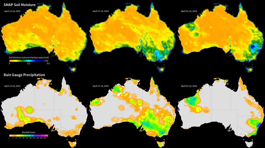
Launched in January 2015, NASA’s Soil Moisture Active-Passive (SMAP) satellite measures global soil moisture from space. These images compare three-day composites of uncalibrated soil moisture data from SMAP [top row] with rain gauge precipitation data from the Australian Bureau of Meteorology [bottom row] in April 2015. In the southeastern Australian state New South Wales, the April 14-16 images [left] show little precipitation and relatively dry soil moisture conditions. Later in the month, widespread rain and flooding gave way to saturated soil on April 17-19 [middle] and April 21-23 [right] as an intense low-pressure system brought heavy rainfall to the region. The soil moisture data were acquired by SMAP’s radiometer instrument and show the volumetric water content in the top 2 inches (5 cm) of soil at ~25-mile (40-km) spatial resolution.
Data from SMAP allow scientists to better understand the processes that link the Earth’s water, energy, and carbon cycles, as well as enhance the predictive skills of weather and climate models. In addition, scientists can use these data to develop improved flood prediction and drought monitoring capabilities. Societal benefits include improved water-resource management, agricultural productivity, and wildfire and landslide predictions.
For More Information
Credits
NASA
https://svs.gsfc.nasa.gov/30599
Mission:
Soil Moisture Active Passive (SMAP)
Keywords:
GCMD >> Earth Science >> Agriculture >> Soils >> Soil Moisture/Water Content
SVS >> Hyperwall
NASA Science >> Earth
SVS >> Presentation
GCMD >> Earth Science >> Terrestrial Hydrosphere >> Surface Water >> Floods
GCMD keywords can be found on the Internet with the following citation: Olsen, L.M., G. Major, K. Shein, J. Scialdone, S. Ritz, T. Stevens, M. Morahan, A. Aleman, R. Vogel, S. Leicester, H. Weir, M. Meaux, S. Grebas, C.Solomon, M. Holland, T. Northcutt, R. A. Restrepo, R. Bilodeau, 2013. NASA/Global Change Master Directory (GCMD) Earth Science Keywords. Version 8.0.0.0.0


