Earth
ID: 30501
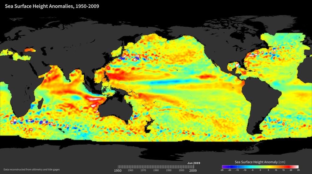
Ocean tide gauges have been used for more than a century to measure sea surface height at specific locations around the globe. Today, scientists combine data from ocean tide gauges with global observations of sea surface height from satellite radar altimeters to detect patterns and monitor changes in ocean height. Currently, NASA’s OSTM/Jason-2 mission—a continuation of the TOPEX/Poseidon and Jason missions—measures the height of the sea surface with an accuracy of about 3 centimeters (just over 1 inch) relative to the center of the Earth. These highly accurate measurements of the height of the sea surface (commonly called “sea level”) are needed to provide long-term information about the world's ocean and its currents. In this visualization, sea surface height anomalies derived from ocean tide gauge data (before 1992) and satellite altimeter data (after 1992) show differences above and below normally observed sea surface heights from 1950 to 2009. These data help show how much heat is stored in the ocean. For example, El Niño events (characterized by warm water and high sea surface height anomalies in the Eastern Pacific) are visible in 1957, 1965, 1972, 1982, 1987, and 1997 along the Equator. Sea surface height data also have many other applications, such as in fisheries management, navigation, and offshore operations.
Sea Surface Height Anomalies, 1950-2009
For More Information
Credits
Jessica Hausman (NASA/JPL CalTech): Project Support
Marit Jentoft-Nilsen (Global Science and Technology, Inc.): Technical Support
Marit Jentoft-Nilsen (Global Science and Technology, Inc.): Technical Support
Please give credit for this item to:
PODAAC
PODAAC
Short URL to share this page:
https://svs.gsfc.nasa.gov/30501
Missions:
Jason
Ocean Surface Topography Mission/Jason 2
TOPEX/Poseidon
Data Used:
Note: While we identify the data sets used in these visualizations, we do not store any further details nor the data sets themselves on our site.
Keywords:
SVS >> HDTV
SVS >> Hyperwall
NASA Science >> Earth
SVS >> Presentation
SVS >> Sea Surface Height Anomaly
https://svs.gsfc.nasa.gov/30501
Missions:
Jason
Ocean Surface Topography Mission/Jason 2
TOPEX/Poseidon
Data Used:
Jason-2/CNES Poseidon-3 Altimeter/Sea Surface Height also referred to as: SSH
Keywords:
SVS >> HDTV
SVS >> Hyperwall
NASA Science >> Earth
SVS >> Presentation
SVS >> Sea Surface Height Anomaly


