Earth
ID: 30363
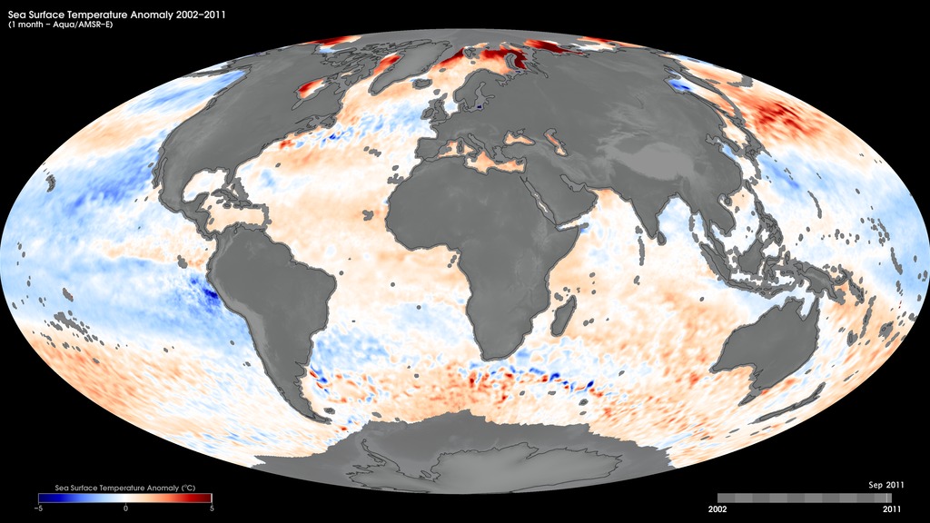
Sea-surface temperature is the temperature of the top millimeter of the ocean's surface. An anomaly is when something is different from normal, or average. A sea-surface temperature anomaly is how different the ocean temperature at a particular location at a particular time is from the normal temperatures for that place. Sea surface temperature anomalies can happen as part of normal ocean cycles or they can be a sign of long-term climate change, such as global warming. These maps show monthly sea-surface temperature anomalies from June 2002 to September 2011, as derived from Aqua’s Advanced Microwave Scanning Radiometer - Earth Observing System (AMSR-E) data. AMSR-E ended data collection in October 2011 due to problems with the rotation of its antenna.
Monthly Sea-Surface Temperature Anomalies
For More Information
Credits
Based on images by Jesse Allen, NASA's Earth Observatory, using Sea Surface Temperature data from the Advanced Microwave Radiometer for EOS (AMSR-E), courtesy Remote Sensing Systems.
Short URL to share this page:
https://svs.gsfc.nasa.gov/30363
Mission:
Aqua
Data Used:
Note: While we identify the data sets used in these visualizations, we do not store any further details nor the data sets themselves on our site.
This item is part of this series:
NASA Earth Observations
Keywords:
SVS >> HDTV
DLESE >> Physical oceanography
SVS >> Sea Surface Temperature Anomaly
GCMD >> Earth Science >> Oceans >> Ocean Temperature >> Sea Surface Temperature
SVS >> Hyperwall
NASA Science >> Earth
SVS >> Presentation
GCMD keywords can be found on the Internet with the following citation: Olsen, L.M., G. Major, K. Shein, J. Scialdone, S. Ritz, T. Stevens, M. Morahan, A. Aleman, R. Vogel, S. Leicester, H. Weir, M. Meaux, S. Grebas, C.Solomon, M. Holland, T. Northcutt, R. A. Restrepo, R. Bilodeau, 2013. NASA/Global Change Master Directory (GCMD) Earth Science Keywords. Version 8.0.0.0.0
https://svs.gsfc.nasa.gov/30363
Mission:
Aqua
Data Used:
Aqua/AMSR-E
For more information, please click http://wwwghcc.msfc.nasa.gov/AMSR/
Aqua/AMSR-E/Sea Surface Temperature Anomaly
This item is part of this series:
NASA Earth Observations
Keywords:
SVS >> HDTV
DLESE >> Physical oceanography
SVS >> Sea Surface Temperature Anomaly
GCMD >> Earth Science >> Oceans >> Ocean Temperature >> Sea Surface Temperature
SVS >> Hyperwall
NASA Science >> Earth
SVS >> Presentation
GCMD keywords can be found on the Internet with the following citation: Olsen, L.M., G. Major, K. Shein, J. Scialdone, S. Ritz, T. Stevens, M. Morahan, A. Aleman, R. Vogel, S. Leicester, H. Weir, M. Meaux, S. Grebas, C.Solomon, M. Holland, T. Northcutt, R. A. Restrepo, R. Bilodeau, 2013. NASA/Global Change Master Directory (GCMD) Earth Science Keywords. Version 8.0.0.0.0


