Earth
ID: 2987
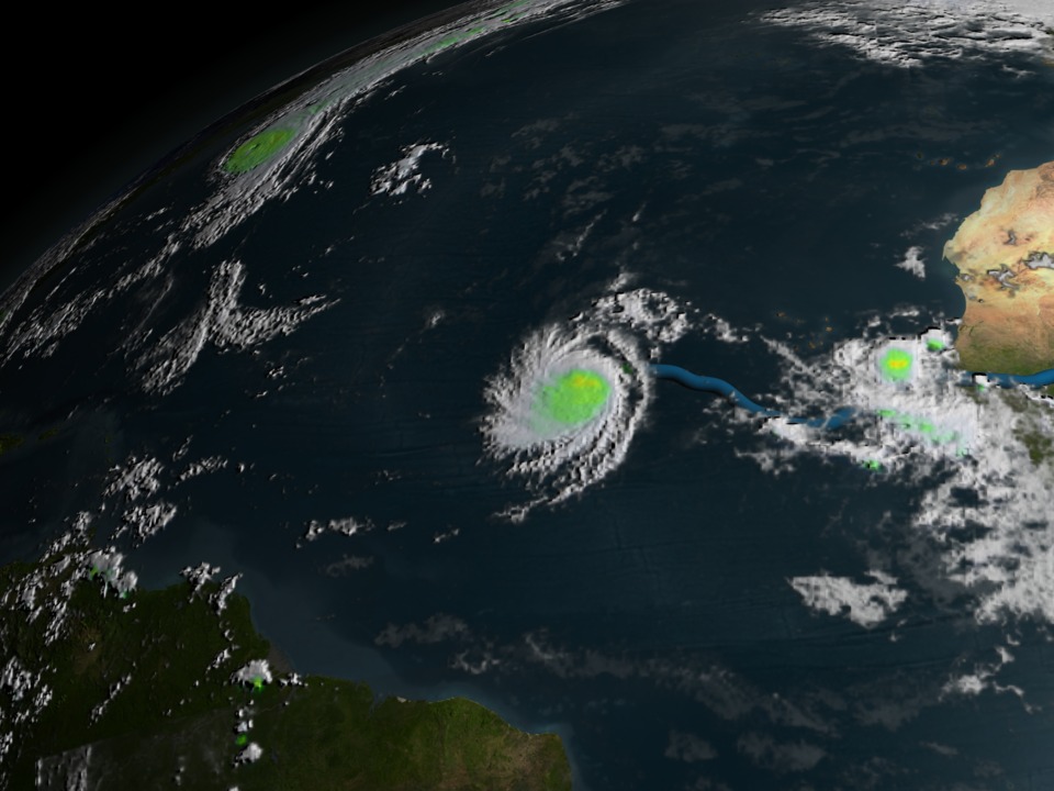
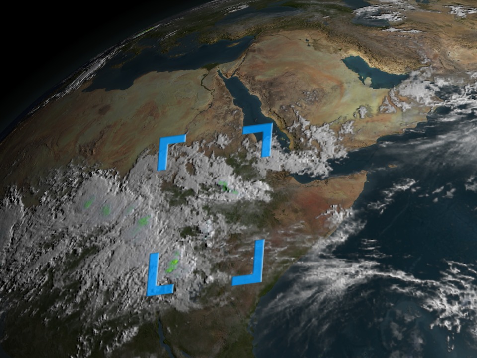
This animation follows Hurricane Isabel (2003) from its birthplace in the Ethiopian Highlands of East Africa, across the Atlantic Ocean, to the United States. Atlantic hurricanes are often formed as winds over the Gulf of Aden intersect with the Ethiopian Highlands. This animation zooms into the Ethiopian Highlands and shows several storms being formed. Then, the animation dissolves in a reticle to focus in specifically on the formation of Hurricane Isabel. The reticle follows the storm across Africa and into the Atlantic. The path and intensity of Hurricane Isabel is depicted by a colored path. Blue represents the genesis of the storm. Green is a Tropical Depression where winds are less than 39 miles per hour. Yellow is a Tropical Storm where winds are between 39 and 73 miles per hour. Red is a category 1 hurricane where winds are between 74 and 95 miles per hour. Light Red is a category 2 hurricane with winds between 96 and 110 miles per hour. Magenta is a category 3 hurricane with winds between 111 and 130 miles per hour. Light magenta is a category 4 hurricane with winds between 131 and 154 miles per hour. White represents a category 5 hurricane where winds are greater than 155 miles per hour. Note how Isabel gains size and speed over the warm waters of the Atlantic.


Hurricane Isabel Genesis
Visualization Credits
Lori Perkins (NASA/GSFC): Lead Animator
Greg Shirah (NASA/GSFC): Animator
Alex Kekesi (Global Science and Technology, Inc.): Animator
Jeff Halverson (JCET UMBC): Scientist
Greg Shirah (NASA/GSFC): Animator
Alex Kekesi (Global Science and Technology, Inc.): Animator
Jeff Halverson (JCET UMBC): Scientist
Please give credit for this item to:
NASA/Goddard Space Flight Center Scientific Visualization Studio
NASA/Goddard Space Flight Center Scientific Visualization Studio
Short URL to share this page:
https://svs.gsfc.nasa.gov/2987
Missions:
Shuttle Radar Topography Mission - SRTM
Tropical Rainfall Measuring Mission - TRMM
Data Used:
Note: While we identify the data sets used in these visualizations, we do not store any further details nor the data sets themselves on our site.
This item is part of these series:
TRMM 3D Hurricanes
Hurricanes
Keywords:
DLESE >> Atmospheric science
SVS >> HDTV
SVS >> Isabel
DLESE >> Natural hazards
GCMD >> Earth Science >> Atmosphere >> Atmospheric Phenomena >> Hurricanes
GCMD >> Location >> Red Sea
GCMD >> Location >> Ethiopia
GCMD >> Location >> Africa
GCMD >> Location >> Maryland
GCMD >> Location >> North Carolina
GCMD >> Location >> Virginia
SVS >> Gulf Of Aden
SVS >> GOES
SVS >> For Educators
SVS >> Atmospheric Circulation
SVS >> Hurricanes >> Isabel
SVS >> Atmospheric Science
SVS >> Meteorological Phenomenon
NASA Science >> Earth
GCMD keywords can be found on the Internet with the following citation: Olsen, L.M., G. Major, K. Shein, J. Scialdone, S. Ritz, T. Stevens, M. Morahan, A. Aleman, R. Vogel, S. Leicester, H. Weir, M. Meaux, S. Grebas, C.Solomon, M. Holland, T. Northcutt, R. A. Restrepo, R. Bilodeau, 2013. NASA/Global Change Master Directory (GCMD) Earth Science Keywords. Version 8.0.0.0.0
Places you might have seen this:
http://www.gsfc.nasa.gov/topstory/2004/0915isabel/media.html, Discovery Channel August 5/6, 2004
https://svs.gsfc.nasa.gov/2987
Missions:
Shuttle Radar Topography Mission - SRTM
Tropical Rainfall Measuring Mission - TRMM
Data Used:
GMS-4/VISSR
GOES-8/Imager
GOES-9/Imager
METEOSAT-6/VISSR
SRTM/SIR-C
HURDAT
Database - NOAATRMM and DMSP/SSM/I and TMI/3B4XRT also referred to as: 3-hour Rainmap
2003/08/27 - 2003/09/19Infrared Global Geostationary Composite
Data Compilation - National Center for Environmental Prediction/Aviation Weather Center (NCEP/AWS) - 2003/08/20 - 2003/09/19
Satellite Data Used to Produce WORLD-IR14KM Mosaic: GOES-11 - Southern hemisphere Band 4 10.7 um IR, Northern hemisphere Band 4 10.7 um IR; GOES-12 - Southern hemisphere Band 4 10.7 um IR, Northern hemisphere Band 4 10.7 um IR; Meteosat-7 - Band 8 11.5 um IR; Meteosat-9 - Band 9 10.8 um IR; MTSAT-1R - Band 2 10.8 um IR; NOAA-15 - Band 4 11 micron IR; NOAA-16 - Band 4 11 micron IR; NOAA-17 - Band 4 11 micron IR
This item is part of these series:
TRMM 3D Hurricanes
Hurricanes
Keywords:
DLESE >> Atmospheric science
SVS >> HDTV
SVS >> Isabel
DLESE >> Natural hazards
GCMD >> Earth Science >> Atmosphere >> Atmospheric Phenomena >> Hurricanes
GCMD >> Location >> Red Sea
GCMD >> Location >> Ethiopia
GCMD >> Location >> Africa
GCMD >> Location >> Maryland
GCMD >> Location >> North Carolina
GCMD >> Location >> Virginia
SVS >> Gulf Of Aden
SVS >> GOES
SVS >> For Educators
SVS >> Atmospheric Circulation
SVS >> Hurricanes >> Isabel
SVS >> Atmospheric Science
SVS >> Meteorological Phenomenon
NASA Science >> Earth
GCMD keywords can be found on the Internet with the following citation: Olsen, L.M., G. Major, K. Shein, J. Scialdone, S. Ritz, T. Stevens, M. Morahan, A. Aleman, R. Vogel, S. Leicester, H. Weir, M. Meaux, S. Grebas, C.Solomon, M. Holland, T. Northcutt, R. A. Restrepo, R. Bilodeau, 2013. NASA/Global Change Master Directory (GCMD) Earth Science Keywords. Version 8.0.0.0.0
Places you might have seen this:
http://www.gsfc.nasa.gov/topstory/2004/0915isabel/media.html, Discovery Channel August 5/6, 2004


