Earth
ID: 2745
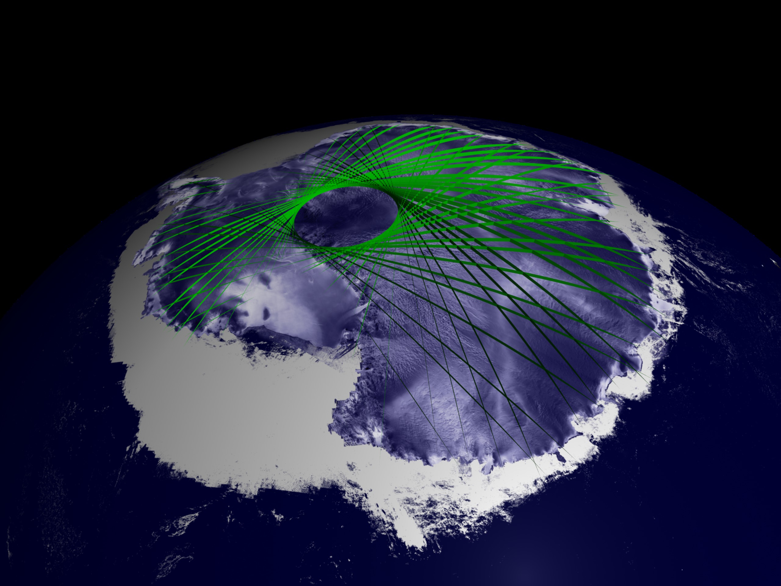
ICESat's orbit was designed to maximize coverage over the great polar ice sheets, where ground tracks overlap to create an intricate grid of data points. The accumulation of these data points in the Southern Hemisphere results in a new three-dimensional elevation model of Antarctica. ICESat repeats its orbital pattern every eight days, allowing the GLAS instrument to measure changes over time in the same location. In order to measure ice sheet mass balance, the satellite's advanced technology is providing data on the critically important third dimension, elevation.

ICESat First Light Release: Antarctica in Three Dimensions
Visualization Credits
Greg Shirah (NASA/GSFC): Lead Animator
Alex Kekesi (Global Science and Technology, Inc.): Animator
Christopher Shuman (NASA/GSFC): Scientist
Jay Zwally (NASA/GSFC): Scientist
Alex Kekesi (Global Science and Technology, Inc.): Animator
Christopher Shuman (NASA/GSFC): Scientist
Jay Zwally (NASA/GSFC): Scientist
Please give credit for this item to:
NASA/Goddard Space Flight Center Scientific Visualization Studio, Canadian Space Agency, RADARSAT International Inc. The Blue Marble Next Generation data is courtesy of Reto Stockli (NASA/GSFC) and NASA's Earth Observatory.
NASA/Goddard Space Flight Center Scientific Visualization Studio, Canadian Space Agency, RADARSAT International Inc. The Blue Marble Next Generation data is courtesy of Reto Stockli (NASA/GSFC) and NASA's Earth Observatory.
Short URL to share this page:
https://svs.gsfc.nasa.gov/2745
Missions:
Ice, Cloud, and land Elevation Satellite (ICESat)
Terra
Data Used:
Note: While we identify the data sets used in these visualizations, we do not store any further details nor the data sets themselves on our site.
Dates of Data Used:
Simulated Data
This item is part of this series:
ICESat
Keywords:
SVS >> Ice
DLESE >> Technology
GCMD >> Location >> Antarctica
NASA Science >> Earth
GCMD keywords can be found on the Internet with the following citation: Olsen, L.M., G. Major, K. Shein, J. Scialdone, S. Ritz, T. Stevens, M. Morahan, A. Aleman, R. Vogel, S. Leicester, H. Weir, M. Meaux, S. Grebas, C.Solomon, M. Holland, T. Northcutt, R. A. Restrepo, R. Bilodeau, 2013. NASA/Global Change Master Directory (GCMD) Earth Science Keywords. Version 8.0.0.0.0
https://svs.gsfc.nasa.gov/2745
Missions:
Ice, Cloud, and land Elevation Satellite (ICESat)
Terra
Data Used:
Terra and Aqua/MODIS/Blue Marble: Next Generation also referred to as: BMNG
1/1/2004 - 12/31/2004
Credit:
The Blue Marble data is courtesy of Reto Stockli (NASA/GSFC).
The Blue Marble data is courtesy of Reto Stockli (NASA/GSFC).
RADARSAT-1/SAR
Credit:
Additional credit goes to Canadian Space Agency, RADARSAT International Inc.
Additional credit goes to Canadian Space Agency, RADARSAT International Inc.
ICESat/GLAS
Dates of Data Used:
Simulated Data
This item is part of this series:
ICESat
Keywords:
SVS >> Ice
DLESE >> Technology
GCMD >> Location >> Antarctica
NASA Science >> Earth
GCMD keywords can be found on the Internet with the following citation: Olsen, L.M., G. Major, K. Shein, J. Scialdone, S. Ritz, T. Stevens, M. Morahan, A. Aleman, R. Vogel, S. Leicester, H. Weir, M. Meaux, S. Grebas, C.Solomon, M. Holland, T. Northcutt, R. A. Restrepo, R. Bilodeau, 2013. NASA/Global Change Master Directory (GCMD) Earth Science Keywords. Version 8.0.0.0.0


