Earth
ID: 2741
ICESat's first topographic profiles across the continent reveal the textured surfaces of Antarctic ice sheets in unprecedented detail. The following profile spans the entire Antarctic continent from coast to coast. The transect begins near Wrigley Gulf, crosses the Ross Ice Shelf and central Antarctica, finally tapering off at the Amery Ice Shelf. The high flat area in the center of the continent is called the East Antarctic plateau.
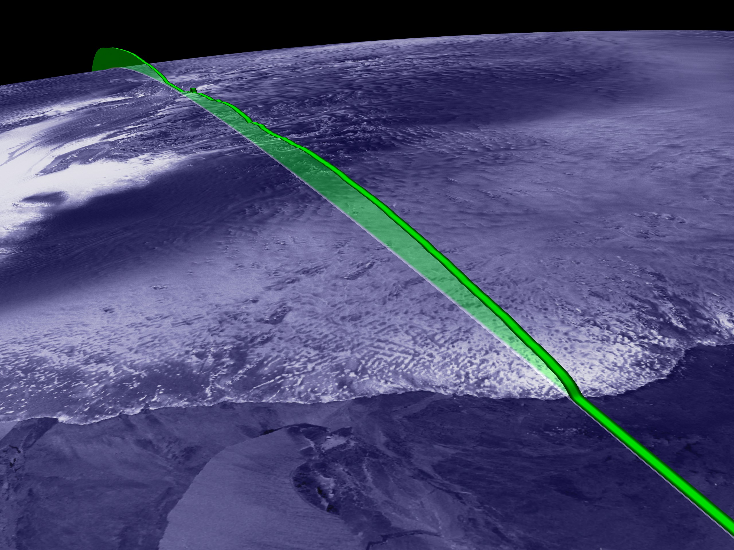


ICESat First Light Release: Antarctica, from Coast to Coast
Visualization Credits
Alex Kekesi (Global Science and Technology, Inc.): Lead Animator
Greg Shirah (NASA/GSFC): Animator
Christopher Shuman (NASA/GSFC): Scientist
Jay Zwally (NASA/GSFC): Scientist
Greg Shirah (NASA/GSFC): Animator
Christopher Shuman (NASA/GSFC): Scientist
Jay Zwally (NASA/GSFC): Scientist
Please give credit for this item to:
NASA/Goddard Space Flight Center Scientific Visualization Studio, Canadian Space Agency, RADARSAT International Inc.
NASA/Goddard Space Flight Center Scientific Visualization Studio, Canadian Space Agency, RADARSAT International Inc.
Short URL to share this page:
https://svs.gsfc.nasa.gov/2741
Missions:
Ice, Cloud, and land Elevation Satellite (ICESat)
Terra
Data Used:
Note: While we identify the data sets used in these visualizations, we do not store any further details nor the data sets themselves on our site.
This item is part of this series:
ICESat
Keywords:
SVS >> Laser
GCMD >> Earth Science >> Land Surface >> Topography >> Terrain Elevation
NASA Science >> Earth
GCMD keywords can be found on the Internet with the following citation: Olsen, L.M., G. Major, K. Shein, J. Scialdone, S. Ritz, T. Stevens, M. Morahan, A. Aleman, R. Vogel, S. Leicester, H. Weir, M. Meaux, S. Grebas, C.Solomon, M. Holland, T. Northcutt, R. A. Restrepo, R. Bilodeau, 2013. NASA/Global Change Master Directory (GCMD) Earth Science Keywords. Version 8.0.0.0.0
https://svs.gsfc.nasa.gov/2741
Missions:
Ice, Cloud, and land Elevation Satellite (ICESat)
Terra
Data Used:
RADARSAT-1/SAR
1997/09/26-1997/11/04
Credit:
Additional credit goes to Canadian Space Agency, RADARSAT International Inc.
Additional credit goes to Canadian Space Agency, RADARSAT International Inc.
Terra/MODIS
2001/06-2001/09ICESat/GLAS/L1B Global Elevation Data (GLA06)
2003/02/22This item is part of this series:
ICESat
Keywords:
SVS >> Laser
GCMD >> Earth Science >> Land Surface >> Topography >> Terrain Elevation
NASA Science >> Earth
GCMD keywords can be found on the Internet with the following citation: Olsen, L.M., G. Major, K. Shein, J. Scialdone, S. Ritz, T. Stevens, M. Morahan, A. Aleman, R. Vogel, S. Leicester, H. Weir, M. Meaux, S. Grebas, C.Solomon, M. Holland, T. Northcutt, R. A. Restrepo, R. Bilodeau, 2013. NASA/Global Change Master Directory (GCMD) Earth Science Keywords. Version 8.0.0.0.0


