Earth
ID: 2102
This animation is a close up zoom into largest area of glacier recesion at the Breidamerkurjokull glacier in Iceland. The data from 1997 is taken from Landsat 5 and the 2000 data is from Landsat 7. The Breidamerkurjokull glacier in Iceland has been measured by Landsat to be receding since 1973. In 1997, Landsat 5 took several other images of the glacier. It was thought by some glacierologists that this particular glacier was receding quicker in the late 1990s than it did in the late 1980s or 1970s. After careful analysis Goddard's Glacierologist, Dorothy Hall, concluded that the recession from 1997 to 2000 occurs at a similar rate to the recession between 1973 and 2000. It is extremely controversial whether or not this recession is caused by global warming.
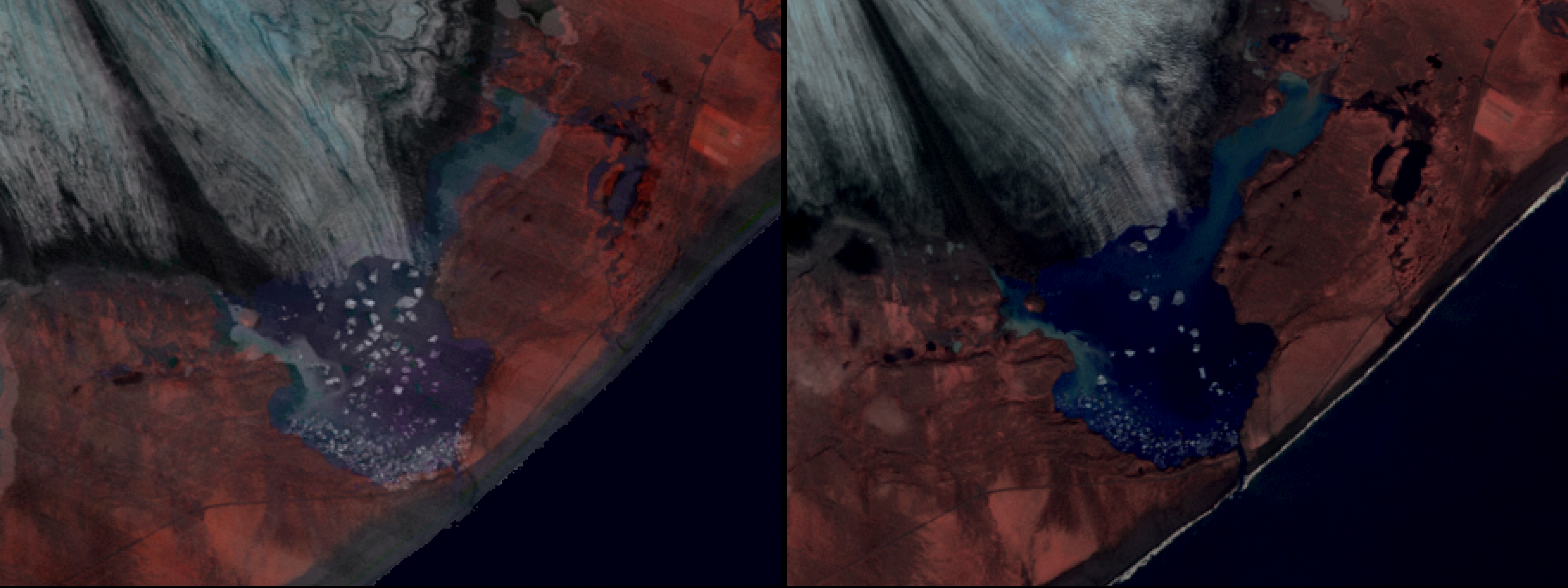


Iceland Glacier Recession 1997 to 2000
Visualization Credits
Please give credit for this item to:
NASA/Goddard Space Flight Center Scientific Visualization Studio
NASA/Goddard Space Flight Center Scientific Visualization Studio
Short URL to share this page:
https://svs.gsfc.nasa.gov/2102
Mission:
Landsat
Data Used:
Note: While we identify the data sets used in these visualizations, we do not store any further details nor the data sets themselves on our site.
This item is part of this series:
Iceland
Keywords:
SVS >> Breidamerkurjokull
DLESE >> Climatology
DLESE >> Cryology
SVS >> Recession
GCMD >> Location >> Iceland
SVS >> Glaciers
NASA Science >> Earth
GCMD keywords can be found on the Internet with the following citation: Olsen, L.M., G. Major, K. Shein, J. Scialdone, S. Ritz, T. Stevens, M. Morahan, A. Aleman, R. Vogel, S. Leicester, H. Weir, M. Meaux, S. Grebas, C.Solomon, M. Holland, T. Northcutt, R. A. Restrepo, R. Bilodeau, 2013. NASA/Global Change Master Directory (GCMD) Earth Science Keywords. Version 8.0.0.0.0
https://svs.gsfc.nasa.gov/2102
Mission:
Landsat
Data Used:
Landsat-7/ETM+
2000/09Landsat-5/TM
1997/09This item is part of this series:
Iceland
Keywords:
SVS >> Breidamerkurjokull
DLESE >> Climatology
DLESE >> Cryology
SVS >> Recession
GCMD >> Location >> Iceland
SVS >> Glaciers
NASA Science >> Earth
GCMD keywords can be found on the Internet with the following citation: Olsen, L.M., G. Major, K. Shein, J. Scialdone, S. Ritz, T. Stevens, M. Morahan, A. Aleman, R. Vogel, S. Leicester, H. Weir, M. Meaux, S. Grebas, C.Solomon, M. Holland, T. Northcutt, R. A. Restrepo, R. Bilodeau, 2013. NASA/Global Change Master Directory (GCMD) Earth Science Keywords. Version 8.0.0.0.0


