Earth
ID: 1401
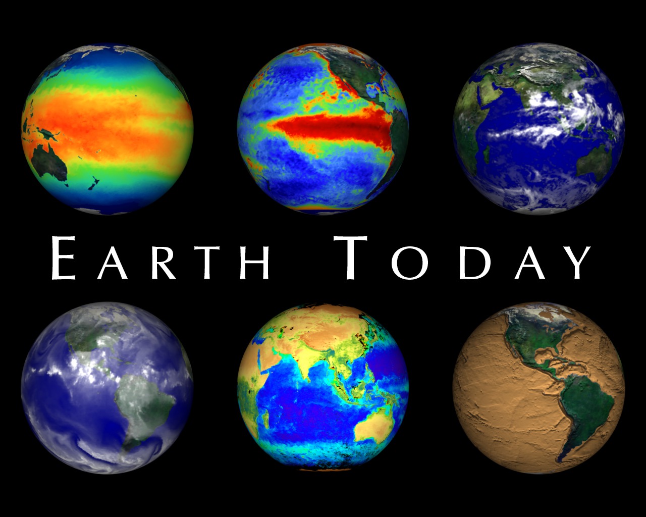
The ability to see Earth from space has forever changed our view of the planet. We are now able to look at the Earth as a whole, and observe how its atmosphere, oceans, land masses, and life interact as global systems. Earth's atmosphere, hydrosphere, geosphere, and biosphere are dynamic, changing on timescales of days, minutes, or even seconds. Monitoring the Earth in near real time allows us to get an up to date picture of conditions on our planet. More SVS visualizations for the Earth Today exhibit can be found in animation ids 328 and 1402.
Earth Today 1998 Introduction
For More Information
Visualization Credits
Alex Kekesi (Global Science and Technology, Inc.): Lead Animator
Wendy Shoan (NASA): Animator
Erica Drezek (HTSI): Narrator
James Earl Jones: Narrator
Tom Watters (Smithsonian/Air and Space): Scientist
Tom Watters (Smithsonian/Air and Space): Writer
Wendy Shoan (NASA): Animator
Erica Drezek (HTSI): Narrator
James Earl Jones: Narrator
Tom Watters (Smithsonian/Air and Space): Scientist
Tom Watters (Smithsonian/Air and Space): Writer
Please give credit for this item to:
NASA/Goddard Space Flight Center,
NASA/Jet Propulsion Laboratory/Caltech,
United States Geological Survey,
Goddard Institute for Space Studies,
Global Processing Center for International Satellite,
Cloud Climatology Project, World Climate Research Program,
NASA/Stennis Space Center,
Naval Oceanographic Office and Northrop Grumman/DSSD,
United States Naval Research Laboratory,
Smithsonian Institution Global Volcanism Program,
United States Geological Survey,
National Earthquake Information Service,
National Earthquake Information Center,
US Air Force Defense Meteorological Satellite Program,
National Oceanic and Atmospheric Administration,
National Geophysical Data Center,
University of Wisconsin,
Space Science and Engineering Center,
NASA/Goddard Space Flight Center,
The SeaWiFS Project and GeoEye,
Scientific Visualization Studio.
NOTE: All SeaWiFS images and data presented on this web site are for research and educational use only. All commercial use of SeaWiFS data must be coordinated with GeoEye (NOTE: In January 2013, DigitalGlobe and GeoEye combined to become DigitalGlobe).
NASA/Goddard Space Flight Center,
NASA/Jet Propulsion Laboratory/Caltech,
United States Geological Survey,
Goddard Institute for Space Studies,
Global Processing Center for International Satellite,
Cloud Climatology Project, World Climate Research Program,
NASA/Stennis Space Center,
Naval Oceanographic Office and Northrop Grumman/DSSD,
United States Naval Research Laboratory,
Smithsonian Institution Global Volcanism Program,
United States Geological Survey,
National Earthquake Information Service,
National Earthquake Information Center,
US Air Force Defense Meteorological Satellite Program,
National Oceanic and Atmospheric Administration,
National Geophysical Data Center,
University of Wisconsin,
Space Science and Engineering Center,
NASA/Goddard Space Flight Center,
The SeaWiFS Project and GeoEye,
Scientific Visualization Studio.
NOTE: All SeaWiFS images and data presented on this web site are for research and educational use only. All commercial use of SeaWiFS data must be coordinated with GeoEye (NOTE: In January 2013, DigitalGlobe and GeoEye combined to become DigitalGlobe).
Short URL to share this page:
https://svs.gsfc.nasa.gov/1401
Mission:
Galileo
Data Used:
Note: While we identify the data sets used in these visualizations, we do not store any further details nor the data sets themselves on our site.
Dates of Data Used:
Various
This item is part of these series:
HoloGlobe and Earth Today
Narrated Movies
Keywords:
DLESE >> Atmospheric science
DLESE >> Biological oceanography
DLESE >> Climatology
DLESE >> Geology
DLESE >> Human geography
DLESE >> Hydrology
SVS >> Mars
DLESE >> Natural hazards
DLESE >> Physical oceanography
SVS >> SST
SVS >> SST Anomaly
DLESE >> Space science
SVS >> Venus
SVS >> GOES
DLESE >> Narrated
SVS >> Voice Over Talent
NASA Science >> Earth
https://svs.gsfc.nasa.gov/1401
Mission:
Galileo
Data Used:
Water Vapor Composite
University of WisconsinUSGS/NEIC/Earthquake Activity
National Earthquake Information Center
SeaStar/SeaWiFS/Global Biosphere
SeaWiFS Global Biosphere is a combination of the Land NDVI and Chlorophyll Concentration data sets. All SeaWiFS images and data presented on this web site are for research and educational use only. All commercial use of SeaWiFS data must be coordinated with GeoEye.
Credit:
NASA/Goddard Space Flight Center, The SeaWiFS Project and GeoEye, Scientific Visualization Studio. NOTE: All SeaWiFS images and data presented on this web site are for research and educational use only. All commercial use of SeaWiFS data must be coordinated with GeoEye (NOTE: In January 2013, DigitalGlobe and GeoEye combined to become one DigitalGlobe.).
NASA/Goddard Space Flight Center, The SeaWiFS Project and GeoEye, Scientific Visualization Studio. NOTE: All SeaWiFS images and data presented on this web site are for research and educational use only. All commercial use of SeaWiFS data must be coordinated with GeoEye (NOTE: In January 2013, DigitalGlobe and GeoEye combined to become one DigitalGlobe.).
NOAA/AVHRR/Sea Surface Temperature Anomaly
NOAA/AVHRR/Sea Surface Temperature
NOAA/AVHRR/NDVI
Infrared Global Composite
Data Compilation - University of Wisconsin
Includes data from FY-2/VISSR, GMS-5/VISSR, GOES-8/Sounder, GOES-9/Sounder, and Meteosat-7/VISSR
Seismic Recording Networks
TAO/TRITON
Galileo/Solid-State Imaging Camera
NASA/JPLDMSP/OLS
Defense Meteorological Satellite Program Operational Linescan System
Dates of Data Used:
Various
This item is part of these series:
HoloGlobe and Earth Today
Narrated Movies
Keywords:
DLESE >> Atmospheric science
DLESE >> Biological oceanography
DLESE >> Climatology
DLESE >> Geology
DLESE >> Human geography
DLESE >> Hydrology
SVS >> Mars
DLESE >> Natural hazards
DLESE >> Physical oceanography
SVS >> SST
SVS >> SST Anomaly
DLESE >> Space science
SVS >> Venus
SVS >> GOES
DLESE >> Narrated
SVS >> Voice Over Talent
NASA Science >> Earth


